|
|
|
|
|
|
|
|
|||||||||||||||||||||||
|
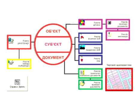
Abstract Study and analysis of the land cadastre geoinformation systems The natural resource is national wealth folk, natural base firm of the social-economic development, eventually, defining and possibility of existence of the person itself. One of the most important natural wealth in our country is a land resource. Or free land-usage, defining our attitude to the land in our country, promoted, irrational use of the most valuable resource - lands. The reliable information about the land has very great importance for management of land resources, whether it is the development of the stable agriculture, or management of the city development. The automatic systems of the conducting of the state land cadastre become very useful instrument for land governing. This explains the urgency of the subject of the master work. Resulting from urgency of the creation of the information cadastre systems, purpose of the master work is defined, which consists of the showing of the market of the existing cadastral systems and analyzing of the data to choose the most suitable, practical, cadastral system. In concordance with the deliver it is necessary to solve the following problems: - determination of the land state cadastre; - determination of the automatic system of the state land cadastre; - study cadastral systems "ASGZK DONNTU"; - study cadastral systems "GIS 6"; - cadastral systems choice. Moment the problem of the state cadastre system is very urgent. There are a lot of programme products, the mostly spread and acceptable "ASGZK DONNTU" and "GIS 6" (refer to tabl. 1). Both cadastre systems for initializing of the graphics use ArcView, are the first system is founded on module MapObject, but the second is on MapDraw. The used type of the server InterBase in "ASGZK DONNTU" and Microsoft SQL Server 2000 in "GIS 6". The First cadastre system contains the general database. Qualifiers created in manually are not used. The second cadastre system consists of the two databases: - a general-purpose, which contains the list of qualifiers; - a worker, containing data filled by user. When filling the register in "GIS 6" bases list are used and is filling roll automatic (refer to fig.1): - a land area; - technical documentation; - state acts; - agreements of the lease; - books to registrations; - a registration card.
Figure - 1 Model database GIS 6 In "ASGZK DONNTU" data can is be filled by the contributed organizations executing cadastre work, selection of data occurs by the skilled specialist in this area. The following rolls are used (refer to fig. 2): - a land area; - technical documentation; - legal documents; - right-ordered documents; - a lease; - registration book.
Figure - 2 Decorated model database ASGZK DONNTU The Imported formats of the files "GIS 6" *Xls, *Pts, *Txt, *Dbf/ *Shp, *Sdr, *Wor, *Art, *Xyz, *In4, *I15, *Gbd, *Cat, *Ics, *Dat, *Mif/*Mid, *Dmf, *Equ, but "ASGZK DONNTU" *In4. To the drawbacks of the "ASGZK DONNTU" we refer show and long process of the translation of the format shared file. Check in "GIS 6" is realized conditionally. Thereby if contribute to the existing shared files it is necessary to have a big amount of time. Contributed 2000 shared files in "GIS 6" did not contain any error. But while contributing too these files to the errors were discovered in "ASGZK DONNTU" the errors were in the administration decision and the share of the land area. Table 1 - cadastre systems сomparison
Has Studied the problem of the absence state cadastre-land of the system in our country, normative-legal base state land cadastre. At the point it is masters of the functioning, I have renewed the base GIS 6 on 2000 fraudulent files and has translated from format * In4. in format *azk such amount. At the moment fill base ASGZK DONNTU. Hereinafter plan the study an cadastre systems, selection the most suitable and practical automated a system land cadastre. The List of the sources: 1. Gavrilenko YU.N., Kalyuzhnyy N.N. Automatic account and analysis of the motion land certificate Collection Engineering geodesy, vyp.45, 2001. - S.79-85 2. Nikonov P.N. ZHuravskiy N.N. History review of the formation кcadasrte systems http://www.allpravo.ru/library/ 3. The Smooth V.I. Kadastrovye work in gorodah. Sib. enterprise by WOUNDS, Novosibirsk: Science 1998. 281 s. 4. Coolness V.V., Radionov G.P., Ore A.I., Kuvshinnikov G.A, Kupeckaya T.A., GIS: real instrument for governing city// Agency of the Cadastre Taganroga http://dataplus.ru/ARCREV/Number_18/3_City.asp?theLink=2 5. S.A. Kadnichanskiy Requirements, presented land by cadastre to spatial given (opinion specialista)http://www.gisa.ru/1960.html 6. Gavrilenko YU.N., Grave S.G., SHolomickiy A.A., Sigitova N.V. The Development automated land-cadastre systems ScienceV працV Donecikogo nacVonalinogo tehnVchnogo unVversitetu, SerVya gVrnicho-geologVchna, vip.62, Donecik, DONNTU, 2003. - S.47-58. 7. Gavrilenko YU.N., Grave S.G., SHolomickiy A.A., Kalyuzhnyy N.N., Sigitova N.V., Dorosh V.R. The Automatic system state land cadastre Doneckoy area Suchasn achievement geodetic sciences production (glance beside HH stolVttya).- Zb.nauk.praci. LivVv, LVga-Pres, 2000. - s.201-203. | |||||||||||||||||||||||||||