
Complete set of apparatus ESA (electronic stop of anomalies) can be assigned to the category of indicator facilities of measurement and is designed for technical implementation of geophysical method of structural geodynamical mapping (SGDM).
The mass of the device together with the set of electric feeding is 6 kilogram’s. Electric feeding of the device is autonomous from two batteries each 12 vault made up from 8 elements type 343. The time of establishment of the made of operation averages up to three minutes.
The general sketchy description of the device is schematized on drawing 1.
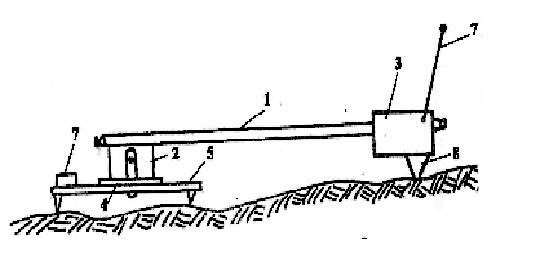
Drawing 1. The general sketchy description of the device
At the ending of dielectric rod (1) generator (2) and receiver (3) are arranged. By the swivel (4) generator is joined to platform (5), that has clinometric limb and magnetic compass (6). The receiver has got a flexible lead (7) a damper bearing (8). The swivel permits to revolve the rod in horizontal plane and to transmit it into vertical plane. At every geophysical piquet operator combines the indicator of the angle of the turn with a zero mark of the limb of the platform, orients the receiver by compass to the North and sets the device by generator to the piquet.
Generator (3) excites harmonic electromagnetic field by inductive way in the mountain range. By the same inductive way the receiver registers amplitude of magnetic component of secondary field, reflecting electrocommunication of investigating nonmagnetic environment. The reading of amplitude in relative units is made at measurement of needle indicator of the receiver.
The main aim of field observations lies in revealing and registration azimuthal non-uniformity of electrical characteristics of superficial rocks horizon on the geophysical piquets in the net of given density of observations. The angle step of observations is usually common practice and it is equal 30 degreeses.
Animation 1 illustrates the scheme of discrete dislocation of the receiver (3) relating to generator (2) in the process of making measurements on the geophysical piquet.
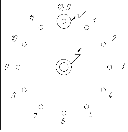
Animation 1.Scheme of discrete dislocation of the receiver relating to generator
The results of survey are brought the field register. Each of the positions of circular cycle is codified by the figure 0-12. The cycle starts and finishes by the position of the receiver (3) towards the North that is by the position 0. The repeated measurement in position 0 provides for inner control.
Industrial and atmospheric interferences to radiation by the device ESA are not practically perceived since the zone of passing way makes up 25 hertz. For performing observations on the geophysical piquet an open area of 1,5 m radius is required. Bushes, thick woods, buildings interfere with pursuance of work. Natural covering, asphalt, concrete, and temporary geological formations like ice, snow are not handicaps if their capacity does not exceed 2 miters. Swamping and mountainous passable regions do nor drop out of zones of possible working. The influence of the relief is insignificant.
Among the geological interferences are the ones due to differences in substances, in structure. Geological interferences are partly suppressed at a point of working up the data. A very high assurance of the results is achieved only while working with non-magnetic surroundings.
On the basis of considerable number of observations it was established that the axes of azimuthal electrocondactivity of investigating mountainous media bent for latitudial and longtitudal directions. Therefore in method SGDM-A for main background field of azimuthal electroconductivity the field corresponding morphologically symmetrical to asteroid directed to the magnetic meridian of the earth is accepted. This background field in method SGDM-A is considered to be megaregional. Above the tectonic violations and zones of their influence background field of azimutal electroconductivity becomes deformed. The extend and character of mode deformations serve as indicators of location the departure of tectonical violations under mellow deposits, azimuth line of its extending and direction of falling. Deformations of azimuthal electroconductivity mode is also observed over surface deformations in the zones of intensive technical influence upon the rock surrounding.
The works concerning irregular rare profile net, constructed along arterial roads, cutting, paths, rivers and other special parts of locality, that provide for trust-worthy stability and high-level possibility in the method SGDM-A are successfully practiced.
This instrument is pertain to a category of indicator means of measurement, therefore no special measures concerning its check-up are provided.