Email: samir2562000@yahoo.fr
Algerian People's Democratic Republic, the State of North Africa. In Arabic sounds as al-Dzhezair ( "islands") is the name of their duty to the emergence of small islands near the capital, the port city of Algiers. Approximately 4 / 5 of the country took Sahara desert. In northern Algeria washed by the Mediterranean Sea, bordered on the east by Tunisia and Libya, in the south of Mali and Niger, Mauritania in the west, the Western Sahara and Morocco. From 8 to. Algeria is a member of the Arab West (Maghreb). From 16 to. the country was under the rule of the Ottoman Empire, and in the mid 19 century. France was occupied. Seven Years' War against the French rule ended with the proclamation of the independence of Algeria in 1962.
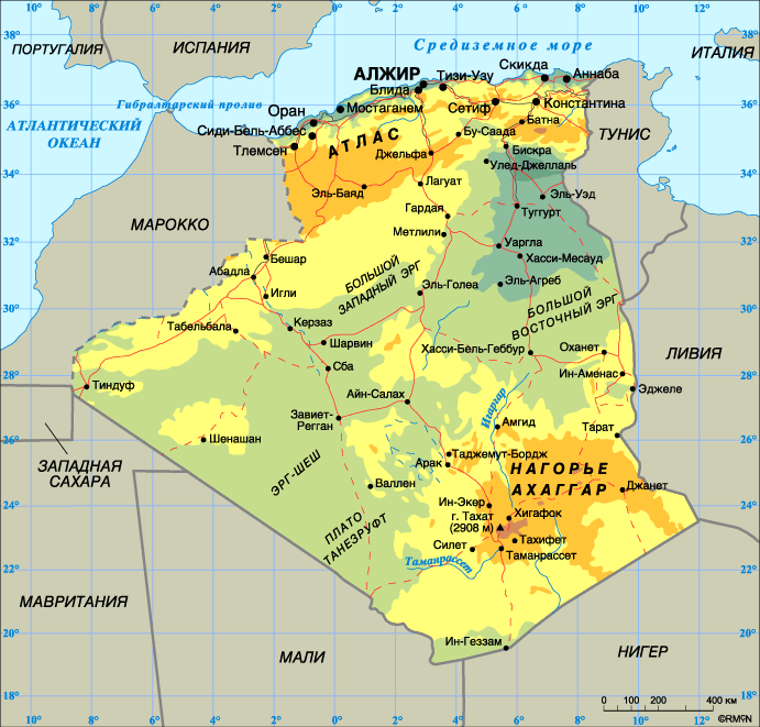
Passing along the north coast of Mountain chain Tell-Atlasa few slots Bay and plains. Lowland cities around Algiers and Oran densely populated. Small bays are used for fishing, export of iron ore and oil. Tell-Atlas rises above sea level by more than 1830 m, and includes an array of Tlemcen, and the Greater and Medzherda Kabiliyu Malaya. In the medium altitudes meet shrubs and Mediterranean-type cork oak forests. At higher mark once spruce pine and pine forests, but as a result of cuttings, fires and cattle pastures, many mountain areas have become covered with scrub Heathland. The climate is Mediterranean, with hot, dry summers and warm rainy winter. In winter, snow covers only the highest peaks. The spread-average rainfall amounts of 760 mm on the coast of up to 1270 mm in the appeals Tell-Atlasa slopes to the sea, and at least 640 mm of the Interior slopes. Southern Tell-Atlasa plateau is a high average altitude of 1070 m. This area is characterized by arid climate with an annual rainfall 250-510 mm. In a more watered areas it’s grain and grass alpha (esparto), which provide fiber for the manufacture of ropes, and high-quality tissue paper. Salt Lake (called Schott), and salt marshes are found at the lower points with a dry climate. Located further to the south Saharan Atlas rises to a height of 150 meters above the plateau and then lowered to the Sahara for more than 300 m. The most elevated part of the Sahara are the Atlas mountain system Ksur, Amur and Uled-Nail. Annual rainfall on the northern slopes of approx. 510 mm in the south-200 mm. Thanks to abundant grass Saharan Atlas provides a convenient area grazing. The rest of the country took the Sahara desert. Average height mark in the Sahara ca. 460 m. The area array Ahaggar (Hoggar) near the southern border of Algeria vertex is the highest mountain of the country Tahat - 2908 m. B o occupy most of the Sahara Desert (Hamad and registration), and approximately 1 / 4 part of sandy desert (ergi). Hot Day, the temperature sometimes reaches 35 °, but the cool nights. Precipitation extremely rare. In the oases, in the face of ongoing irrigation, a growing palm. In Algiers, only a few have the constant flow of rivers, the rest is fed by rainfall. Source water wells serve, dug in dried river bed (wadi), are used in many places underground water coming to the surface through artesian wells and delivery are horizontal tunnels dug under the small classes.
In an era of the French conquest of Algeria's population was approx. 3 million people. In 1966 it had reached already 11823 million people, and in 2003 - 32.82 million people. In 2003 the birth rate was 21.94 per 1000 people, while the mortality rate-5.09 per 1000 people. Infant mortality (infant) was 37.74 per 1000 births. in 2003 approx. 63% of the population was between 15 and 64 years, 32.8% under 15 years old and 4.2% of the population over 65 year .general life in Algeria in 2003 69.14 years for men and 72.01 for women. Initially, Algeria was settled by peoples speaking Berber languages. These peoples already in 2000 BC moved here from the Middle East. B o majority of the population enjoys modern spoken in the home version of the Arabic language. The Arabs settled in Algeria during the Islamic conquest 7-8 cent. and nomadic migrations 11-12 cent. Mixing the two waves of migrants from autochthonous populations has led to the so-called arabo-berberskogo ethnicity, cultural development in the Arab element which belongs to the dominant role. As the majority ethnic subgroup of Algerian society, the Berbers have played an important role in the life of the country. During the Roman and Arab conquest of North Africa, Berbers, many moved to the coast in the highland areas. Berbera is approximately 1 / 5 of the population of the country. The largest concentration is in the Berber population Djhurdjhura mountains to the east of the capital, known as Kabiliya. Local residents, Kabila, settled on many country towns, but still treasured ancient traditions. Other large portions of the Berber population represented by tribal alliances shaviyya, originating in a mountainous region around Batna, mzabita, resettled in the Northern Territory Saharan oases, and tuareg living in the far south in the area Ahaggara. After the conquest of Algeria by France in 19 century. increased strength of the European part of the population, and by 1960 there had already lived ca. 1 million Europeans. Most had French roots, the other ancestors moved from Algeria to France, Italy and Malta. After the proclamation in 1962 of independence of Algeria, most Europeans have left the country. The most of the population of Algeria-Muslims (malikit and hanafit). A number of followers of the sect live in the valley Mzab, Ouargla and Algeria. The state religion is Islam. The country has approx. 150 thousand Christians, mostly Catholics, and about 1 thousand the adherents of Judaism. State language is Arabic, but is still widely available in French. His writing regained some Berber tribes speaking tamahak and tamazirt. At dialect tamazirt in Algiers already had gone a few books. About 3 / 4 of population concentrated in the foothills Tell-Atlasa, approximately 1.5 million people live in the Highland area and less than one million in the Sahara desert. The highest density of states near the capital and in the region Kabily.