ABSTRACT:
Three-dimensional photo-models are object-models with texture information taken from photographs. They can be used to present architectural objects to the public and decision-makers. Photo-realism can only be obtained if the geometry of the building is represented by accurate methods and if texture or real world imagery is additionally mapped to the faces of the objects.
For the modeling of buildings located in urban areas, we consider a first step based on topology structure combined with geometry to construct the more coherent 3D model. Our method is supported by manual and semi-automated procedures for house and roof extraction, based on 3D description of buildings from aerial photographs. Specified Graphical User Interfaces (GUI) have been developed and integrated in the general shape of MicroStation-J toolboxes. These tools are mainly:
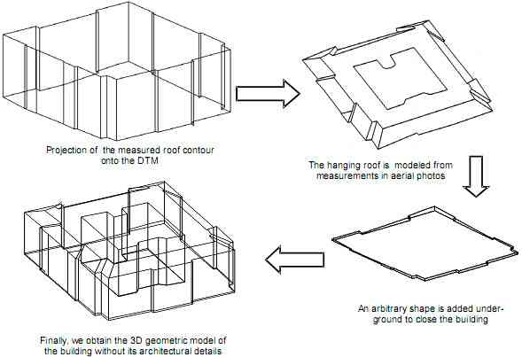
- A "building-generator" which automatically completes the shape of the building by projecting the roof onto the DTM;
- An "Architectural-generator" which automatically completes the different details of the building's faces;
- A "Topology-generator" able to produce structured tables of the graphical elements.
In the second step, the orthophotos processed from the original images are then applied to the faces of the object. Most architectural photogrammetry software packages, since they are mainly used for visualization and animation purposes, allow such a possibility.
Our method has been applied to the zoological museum located in Strasbourg (close to the ENSAIS campus).
1. Introduction
3D modeling methods are of interest for projects in civil engineering, site recording, urban planning, etc. We consider in this paper the 3D description of complex objects and two major components: photogrammetric measurements and automated structuring. The modeling method proposed at first includes the geometry, the topology and the semantic aspects of buildings to be reconstructed from data obtained by aerial and architectural photogrammetric restitution. One of our objectives is to automate more and more the reconstruction of 3D objects. We present the different steps of our method which is available in Specified Graphical User Interfaces (GUI). Our GUI's are developed and integrated in the general shape of Microstation-J tool boxes.
In the second part of the paper, we explain how to improve the models by handling image textures. The object is modeled by faces in Photomodeler software and the 3D geometric model is completed with real textures in order to create a visual-3D- model. The method has been tested on the main building of the zoological museum located in Strasbourg (figure 1).
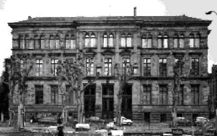
Figure 1. Front view of the zoological museum (our test-object in Strasbourg)
2. General concept
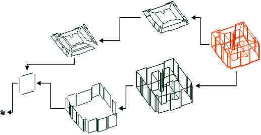
In urban areas, buildings are fundamental objects aimed to be fully modeled in 3D. We assume the building as an envelope which contains elements such as roof, chimneys, walls, doors, windows, etc. This decomposition allows also the attachment of descriptive attributes for the purpose of the Information System. For all that, data structure and the definition of 3D complex geometry must be selected as well as efficient techniques for the visualization to include the mapping of textures on the facades. We describe in figure 2 our photogrammetric and modeling procedures for the generation and the visualization of buildings in 3D.
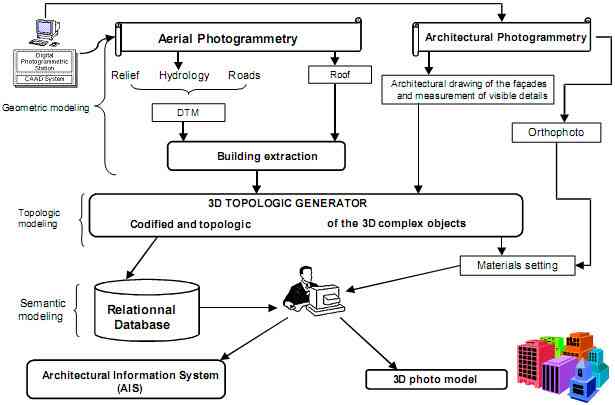
Figure 2. The main steps for 3D modeling of buildings
The current procedure for 3D object reconstruction and visualization is a result of the research carried out at ENSAIS-LERGEC since 1996, initially developed for modeling buildings and monuments in urban areas (Koehl, 1996), (Grussenmeyer et al., 1999), (Nour El Din et al.,2000).
3. Building reconstruction by photogrammetry
Currently 3D buildings reconstruction can be done by three different basic techniques:
- Scanning of maps or landscapes and extraction of buildings;
- Laser scanning and producing of the digital surface model (DSM);
- Photogrammetry.
In our project, photogrammetry techniques are applied. To define our models, we consider:
- aerial photographs : we proceed at first the geometric and semantic modeling of the urban objects of the area, including the restitution of the visible parts of the building plotted in the top view;
- architectural photogrammetry : we define accurately the building with its geometry and the semantic aspects of its details.
The development demands adapted methods of photogrammetric data acquisition and processing, creation of a three dimensional geometric object description as well as photo realistic visualization and guided architectural processing.
3.1. 3D Data acquisition and structuring
The methods presented here uses three major groups of data:
- DTM and the surface objects (features as streets, paths, etc.);
- 3D complex geometric objects (as buildings);
- architectural entities (complex architecture not only for geometric representation but also in thematic structure).
Processing of different types of data involve several steps, which finally leads to the construction of a 3D topologic model to be integrated in the database. The procedure depends on the different categories to be processed (DTM, building, roof, etc.), and on the feature of each category (face of DTM, wall, etc.). Our prototype system allows simple coding of semantic information by numbering building, type of surface and object line.
3.1.1. Digital Terrain Model
The DTM is the key element in our building reconstruction process. We measure terrain elevation values manually because the generation of the DTM is not possible automatically for densely built up urban areas. The points co-ordinates are obtained from the stereomodel. The points of surface objects (roads, bridges, etc.) are digitized and we create a Triangular Irregular Network (TIN) to be used in the reconstruction of the buildings.
3.1.2. 3D complex objects.
The outline of the roof building is obtained using aerial photographs. The stereoplotting is done by digital photogrammetry (figure 3). The photogrammetric tools are coupled with a CAD system to acquire interactively the visible parts of the objects and to achieve the reconstruction by using 3D CAD tools. The process of data collecting consists of measuring 3D points on the roof of the building in arbitrary order.
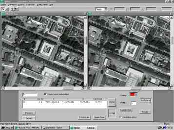
Figure 3. ENSAIS' TIPHON software package for digital photogrammetry
3.1.3. Architectural photogrammetry
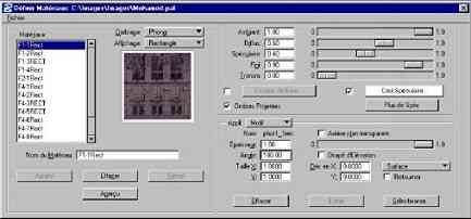
Detailed geometric information of the building was derived from architectural photogrammetry and geodetic measurements. The restitution of objects is based on small and medium format photographs. Site photography was obtained using semi-metric cameras: Pentax 67 metric (70mm*60mm), Rolleimetric 35 (24mm*36mm). The control points (approx. 50) were realized by using geodetic techniques, in the same co-ordinate system as used for aerial photographs. The restitution of the architecturals details of the faзade was done by PhotoModeler software (figure 4).
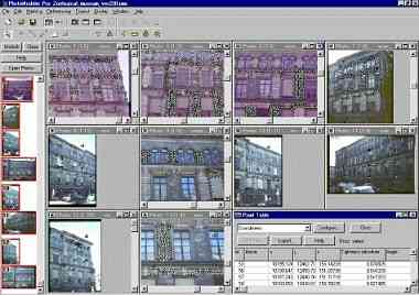
Figure 4. Layout of Photomodeler multi-image screen
The measurement process is done in a mono-comparator mode, where the actual point measurement and referencing between photos is done manually. Orthophotos of complex surfaces can be produced and exported as bitmaps. The export formats for the spatial result are wide-spread and include DXF, and VRML. Full photo-textured 3D "photo-models" may be one of the most interesting results.
Figure 5. Example of photogrammetric restitution (from Photomodeler).
3.2. Prototype for the modeling of 3D objects
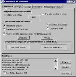
One of our objectives is to automate the reconstruction of objects corresponding to semantic concepts. Specified Graphical User Interfaces (GUI) have been developed and integrated in the general shape of Microstation-J tool boxes. These tools are mainly:
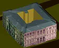
- A "building-generator" which automatically completes the shape of the building by projecting the roof on DTM (figure 6).
- A " generator of architectural details " which automatically completes the different details of the building's faces (figure 7).
- A "Topology-generator" for producing automatically the structured tables of the graphical elements (topographic and architectural elements) in the CAD environment.
This GUI allows the efficient use of algorithms for the extraction of the 3D complex objects and guidance by additional topologic information.