
Introduction Growth of interest for three-dimensional cadastral registration is caused by set of factors:
-substantial growth in a private property;
-increase of number of tunnels, cables and pipelines, underground passages, shopping centers, and other cases of multilevel buildings;
-introduction of three-dimensional approach is in other areas (three-dimensional geographical informative system, three-dimensional planning) which do three-dimensional approach of cadastre registration technologically realizable.
Object of research is the system of registration of the land in Ukraine and abroad.
The purpose of work is research of technology of a three-dimensional cadastre in other countries for the purpose of introduction in Ukraine.
Research has scientific novelty as similar researches in Ukraine were not spent earlier. The three-dimensional cadastre of the Netherlands has been analyzed; the analysis of development of cadastral system in Ukraine and Russia has been made. The basic types of models of the data for creation of three-dimensional model of object of the real estate under the cadastral data have been analyzed. By means of Delphi 5 environment, the program, for representation of the cadastral information in three-dimensional space has been created. The program uses in quality a source of the data database «АСГЗК» created in the environment of Interbase 5, and deduces result in AUTOCAD environment.
By means of the created program there was a possibility of introduction of technology of a three-dimensional cadastre in Ukraine. Result of work will be: sites with three-dimensional co-ordinate in the environment of AUTOCAD and data on them in a database.
In Ukraine importance and necessity of declaring of the property rights, especially individualized rights, increases, when density of the population and earth use increases becomes more intensive. Pressure on land in urban areas and especially their business centers has led to overlapping and interlocking constructions. Even when the creation of property rights to match these developments is available within existing legislation, describing and depicting them in the cadastral registration poses a challenge. This is not surprising when looking at the FIG description of a Cadastre in which the parcel is the basic entity. The challenge is how to register overlapping and interlocking constructions when projected on the surface in a cadastral registration that registers information on 2D parcels. Although property has been located on top of each other for many years, it is only recently that the question has been raised as to whether cadastral registration should be extended into the third dimension. The growing interest for 3D cadastral registration is caused by a number of factors:
-a considerable increase in (private) property values;
-the number of tunnels, cables and pipelines (water, electricity, sewage, telephone, TV cables), underground parking places, shopping malls, buildings above roads/railways and other cases of multilevel buildings has grown considerably in the last forty years;
-an upcoming 3D approach in other domains (3D GIS (Geographical Information Systems), 3D planning) which makes a 3D approach of cadastral registration technologically realizable.
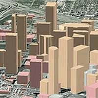
Therefore they also cannot be defined as cadastral object on a cadastral card. Working groups FIG are engaged in research of these problems: the Commissions 3 (Spatial Information Management) and the Commissions 7 (Cadastre and Lang Management) which are created in April, 2002 on congress FIG in Washington. According to the Ground code of Ukraine [2], the property right to the ground area extends on space which is over and under a site surface on height and on the depth, necessary for data of inhabited, industrial and other buildings and constructions. In figure 1 3D-situations displayed.
| |
| Figure 1 - 3D-situations |
| (animation geared-up in Ulead GIF Animator 5 (amount of shots - 6, duration of shot - 1 with, amount of cycles - 15, size of pictures - 200Х200, size - 92 КВ) |
The three-dimensional situation which is characteristic for cities, predetermines necessity for an establishment of borders of the ground areas which will accordand with object of the real estate. Partially such situation is regulated by Rules and order of distribution of territories of inhabited quarter [4], but it any more does not accordand with expenses of time of land owners [8]. Also it is possible to allocate problems which registration of underground infrastructures (tunnels of the underground and engineering communications) as three-dimensional objects concern. In such situations the infrastructure cannot be adhered to a cadastral card in any way and, accordingly, cadastral registration cannot be spent. Indirectly (through available restrictions on use of the ground areas) situations with an underground engineering infrastructure (communication lines, other communications) are registered. Thus the owner of communications in cadastral system is not registered. The stated problems are not new. However they became more obvious last decade when mass privatization of the city earths has begun and when owners of the big objects of the real estate have encountered problems of a legal guarantee of the rights to the real estate. And the overall objective of a cadastre also consists in warranting of legal safety of the ground areas and the real estate on them. It means that the cadastre should guarantee the property rights in all measurements. The the best understanding 3D - situations, the higher legal safety is guaranteed for all complex of the real estate [5].
According to the current registration, the cadastral model of the data in Ukraine should be resulted to level of such model in the majority of the countries of the world (Denmark, Sweden, Israel, Norway, Australia, etc.). But because of defects of some standard documents [1] the previous model continues to operate. A problem that in the Ukrainian legislation of concept "objects of the real estate" and "ground area" on which the objects of the real estate united by the law more recently [1, 3] are placed, and necessary accompanying standard documents only are developed. In cadastral practice of the majority of the countries of concept "real estate" it is defined for a long time [10]. And nevertheless the registration of Ukraine gradually adapts for the legislation of the European Union. According to the law of Ukraine [1], from the state registration of the ground areas, real estate and the rights to them it is necessary to function on the State committee of Ukraine on ground resources. In the country should be generated and to operate the uniform State register of the rights.
To register 3D-situations (see fig. 1) the property rights in an operating cadastre, the legal status of 3D-situations should be displayed so that it could be registered in cadastral system, in particular on a cadastral card. If the cadastral model is led to level of the developed countries then, being based on this model, it is possible to allocate three decisions for registration of 3D-situations: a full 3D-cadastre, a hybrid cadastre, 3D-signs in operating cadastral system of registration [13, 15].
The full 3D-cadastre means that is necessary to enter concept of the property right into three-dimensional space. The legislation, civil-law agreements and a cadastre should support and provide transaction of the three-dimensional rights. Certainly, from the practical point of view it is better to support a 2D-complex of the rights as was till now, and only in difficult three-dimensional situations to use a full three-dimensional complex.
The hybrid cadastre is provided by preservation of a 2D-cadastre and situation registration in the third measurement with fixation thus three-dimensional objects in 2D-cadastre 2D-borders. It will lead to hybrid association of the 2D-ground areas and three-dimensional actual objects.
3D-signs in operating cadastral system of registration provide 2D-cadastre preservation, but with external references to digital representations of three-dimensional situations. Difficult 3D-situations are registered, using special decisions. The elementary decision - to designate a three-dimensional situation during registration that the user has received consultation from the registrar with the detailed information. More difficult decision is to add to a database of the reference to the 3D-digital description of object. Possible use of CAD-formats (DXP, DGN). Then design contours of 3D-object can be registered on a cadastral card [12, 14].
In cities constantly interest increases to the use of space above and under a terrene, because increase capital investment at the use of such space. Accordingly, the cadastral system will approach to that border when it will be compelled to register objects in vertical measurement. In operating system of cadastral registration which is based on 2D-given about the ground areas, it is impossible to support 3D-situations which arise as the property right establishment can occur only on a plane. It is necessary to select software products which in the future will be used for a 3D-cadastre. The existing software for creation of exchange files-registers of the ground areas, visualization of the image of objects of registration and neighbors, reservation are unsatisfactory, and it is necessary to refuse this system as soon as possible as it is necessary to consider modern researches (the Cadastre 2014). Registration system should be based or be integrated in GIS which are intended for processing of the geospatial information, with some built in technologies of the automated designing. In my opinion, such software product can be Autodesk Map 3D. At a present stage of development of system of registration in Ukraine it is necessary to concentrate on development and realization of the concept which is based on 3D - signs in operating cadastral system of registration, with the subsequent transition to the concept of the hybrid decision. The concept 3D - a full cadastre meanwhile is far prospect.
According to an object in view in work are executed:
-the analysis of technology of a three-dimensional cadastre in other countries;
-the analysis of evolution of development of cadastral system;
-formation 3-D models of object of the real estate under the cadastral data;
-creation of a database for representation of the cadastral information in three-dimensional space.