A Vertical Electrical Sounding Method for Soil Survey
Source: http://larisa_pozd.tripod.com/ves/ves.htm
The description: the Example of method VES for soil research.
Authors: Larisa Pozdnyakova, Anatoly Pozdnyakov and Renduo Zhang
A Vertical Electrical Sounding Method for Soil Survey
Electrical methods are intensively used by geophysicists for evaluation of deep subsurface. Measurements of the electrical conductivity or resistivity have been applied for soil salinity surveys in situ for many years (Rhoades and Ingvalson, 1971; Austin and Rhoades, 1979; Rhoades et al., 1990). The most common method is the electrical profiling using four-electrode probes in Wenner configuration. The probes are applied on the soil surface as well as in bore-hole logging (Rhoades and Schilfgaarde, 1976; Halvorson and Rhoades, 1976; Rhoades, 1979). Recently other electrical geophysical methods such as electromagnetic induction (EM) and ground penetrating radar (GPR) become increasingly popular. The methods are still applied preferentially on saline irrigated areas. Some successful applications of the methods were reported on accessing quality of forest soils (McBride et al., 1990), mapping water flow paths (Freeland et al., 1997a), finding perched water locations (Freeland et al., 1997b), and outlining permafrost layers (Arcone et al., 1998). Despite the promising applications, methods of four-electrode profiling, EM, and GPR have some drawbacks when used for shallow soil profiles. Methods of EM and four-electrode probe can not directly measure different resistivities or conductivities of soil horizons and provide only average or bulk electrical conductivity of the soil profile (Corwin and Rhoades, 1984). GPR evaluates profile differentiation in soil electrical conductivity, but its application is limited on soils with high conductivity (salty soils, clay soils). GPR is also not easily modified for shallow subsurface measurements (Liner and Liner, 1997).
Although the method of vertical electrical sounding (VES) is very popular in conventional geophysical studies, such as gas, oil, and coal exploration (Verma and Bandyopadnyay, 1983), it is rarely used in shallow subsurface studies. Vertical electrical sounding was applied to estimate hydraulic conductivity (Mazac et al., 1990) and texture (Banton et al., 1997) of the stratified soils and sediments. Barker (1990) applied VES to a landfill outlining at a 40-m depth. However, the arrays used in these studies can not accurately evaluate very thin (3-30 cm) soil layers. No research has been conducted to evaluate possible applications of the VES method in soil survey for estimating depths and thicknesses of soil horizons. The objectives of our study are to modify the conventional VES method for adequate evaluation of soil horizons and to test the method for soil survey and other possible soil applications.
MATERIALS AND METHODS
The vertical electrical sounding and electrical profiling methods are based on the four-electrode principle as shown in Fig. 1. The electrical current (I) is applied to A and B electrodes and the potential (D U) is measured between M and N electrodes. The bulk soil electrical resistivity (ER) is calculated with
![]() [1]
[1]
where K is the geometric factor.
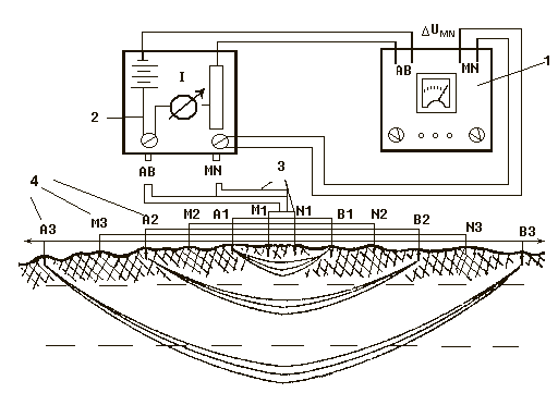
Fig. 1. Scheme of the vertical electrical sounding (VES) device: (1) auto-canceller, (2) commutator for electrodes AB and MN, (3) netted wires for different distances among electrodes AB and MN, and (4) electrodes.
Some uncertainties exist in the soil literature about the calculation of K and estimation of the measuring depth with different arrays (Kirkham and Taylor, 1949; Banton et al., 1997). As implied in conventional geophysics, the depth of penetration of electrical field in the media is influenced by the array geometry as well as electrical conductivity and layer organization of the media (Beck, 1981; Barker, 1989; Parasnis, 1997). Therefore, the depth of penetration can not be precisely derived from the distances between the electrodes in an array. Theoretical derivations and practical tests have shown that the approximate penetration depth can be considered as 1/6 of [AB] for the arrays of Schlumberger and Wenner types used on wide range of soils and grounds (Barker, 1989; Pozdnyakov et al., 1996; Pozdnyakova et al., 1996; Banton et al., 1997). However, a depth approximation coefficient has been misused (1/3 of [AB]) for the four-electrode profiling with Wenner array (Halvorson and Rhoades, 1976; Rhoades and Schilfgaarde, 1976).
While the depth of penetration for an array varies for the different soils around 1/6 of [AB], the geometric factor (K) can be precisely derived from the array geometry based on the law of electrical field distribution. Using the Laplace equation in polar coordinates, Keller and Frischknecht (1966) derived the electrical potential functions around the source (A and B) and measuring (M and N) electrodes. The geometric factor K can be obtained for four-electrode array of AMNB configuration as
 [2]
[2]
where [AM], [BM], [AN], and [BN] are the distances (m) between the respective electrodes. For central-symmetric array, when [AM]=[BN] and [BM]=[AN], Eq. [2] can be simplified to
![]() [3]
[3]
The VES array consists of a series of the electrode combinations AMNB with gradually increasing distances among the electrodes for consequent combinations (Fig. 1). The depth of sounding increases with the distance between A and B electrodes. The K factors for the combinations are calculated with Eq. [3] and used to obtain electrical resistivity from measured electrical potential and current using Eq. [1]. The result of VES measurements with central-symmetric arrays is apparent (bulk) electrical resistivity as a function of half of the distance between the current electrodes, i.e. ER=f(AB/2) (Beck, 1981). The relationship between ER and AB/2 can be converted into a relationship between electrical resistivity and actual soil depth through a computer interpretation. Pozdnyakov et al. (1996) developed programs for soil VES interpretations based on an updated R-function. The electrical resistivity measured with the method is shown to be related with salinity, texture and structure, porosity, bulk density, saturation, and hydrological conductivity of the soil (Pozdnyakov et al., 1996; Banton et al., 1997). Thus, the VES profiles can provide information on the geological structures, soil properties, and hydrological conditions in a study area.
We modified the classical geophysical VES array to obtain detailed characteristics of relatively shallow subsurface. Two array configurations are adapted for soil studies. In the first array the [AB/2] distances are fixed as 0.1, 0.15, 0.22, 0.3, 0.45, 0.6, 0.9, 1.2, 1.8, 2.0, 3.6, 4.0, 7.2, 10, and 15 m to ensure a thorough measurement of soil subsurface from 0.02 to 5 m (Pozdnyakov and Chan, 1976). In the second array we increased the [AB/2] distances in a geometrical progression with a coefficient
![]() , which results the sounding data distribute with an equal increment in logarithm coordinates. The distances for the second array are set up as 0.1, 0.13, 0.16, 0.2, 0.25, 0.32, 0.40, 0.5, 0.63, 0.8, 1, 1.3 m, etc. The concurrent MN electrodes are placed symmetrically within the center of [AB] for the both arrays (Fig. 1). Resistivity is measured by different combinations of A, B, M, and N electrodes with an automatic switch between the combinations. Since the boundaries of soil layers are often more diffusive than the boundaries of geological strata, we average 2 to 4 replications with different [MN] distances for a [AB] distance to provide a higher measurement accuracy. The second array provides a very high accuracy essential if the soil profile is relatively uniform in electrical resistivity. The accuracy provided with the first array is adequate for most soil applications. Other modifications of the traditional method include the reduced size and weight of electrodes, arrays with the fixed distances among electrodes, and automatic commutator for the electrode combinations. The equipment with such features allows measuring a detailed VES profile within 10 min using the first array and within 20 min using the second array.
, which results the sounding data distribute with an equal increment in logarithm coordinates. The distances for the second array are set up as 0.1, 0.13, 0.16, 0.2, 0.25, 0.32, 0.40, 0.5, 0.63, 0.8, 1, 1.3 m, etc. The concurrent MN electrodes are placed symmetrically within the center of [AB] for the both arrays (Fig. 1). Resistivity is measured by different combinations of A, B, M, and N electrodes with an automatic switch between the combinations. Since the boundaries of soil layers are often more diffusive than the boundaries of geological strata, we average 2 to 4 replications with different [MN] distances for a [AB] distance to provide a higher measurement accuracy. The second array provides a very high accuracy essential if the soil profile is relatively uniform in electrical resistivity. The accuracy provided with the first array is adequate for most soil applications. Other modifications of the traditional method include the reduced size and weight of electrodes, arrays with the fixed distances among electrodes, and automatic commutator for the electrode combinations. The equipment with such features allows measuring a detailed VES profile within 10 min using the first array and within 20 min using the second array.
To highlight the advantages of VES usage for soil survey we examined soil profiles with highly variable electrical resistivities. The modified VES method was tested in soil horizons outlining in elluvial-alluvial profiles of Spodosols and Alfisols in the humid areas of Russia. Other properties that highly influence the profile distributions of electrical resistivity in soils are salinity, stone or rock content, and pollution by oil or gasoline. Electrical resistivities of stones, rocks, and hydrocarbons such as petroleum, gasoline, bitumen, and oil are about thousand times higher than that of soils, whereas the resistivity of a saline soil can be much lower than that of a non-saline soil. The VES method was applied to evaluate of saline layers and groundwater depths in the alluvial soils of delta Volga, Russia. The profile distributions of stones in soils of Crimea Peninsula, Russia were successfully investigated with the VES method. The pollution by the petroleum mining was revealed in the profiles of Gelisols in North-East Siberia. The VES method was also utilized for in-situ monitoring of soil defrosting and drying processes on cultivated Alfisols and Histosols in Moscow area, Russia.
RESULTS AND DISCUSSION
Outlining of horizons in elluvial-illuvial soil profiles
Soil horizons with highly varied chemical, physical, and electrical properties develop through the soil evolution due to processes of elluviation-illuviation, leaching, calcification-decalcification, lessivage, laterization, etc. (Wilding et al., 1983). For example, a profile of mature Ferrudalf is strongly differentiated in morphology, texture, and chemical properties, therefore, in electrical resistivity (Fig. 2a). The top horizon (A) has a relatively high humus content and cation exchange capacity, hence, a high density of mobile electrical charges and low resistivity. The underlying elluvial (albic) horizon (E) mostly consists of bleached sand grains. The density of mobile electric charges is much lower in E horizon than that in A horizon, therefore, the resistivity of E horizon is higher. The resistivity of the illuvial (spodic or argillic) horizon (B) is the lowest in the profile attributable to enrichment with the fine clay material and Fe+2/+3, Al+3, Mn+5, and other cations.
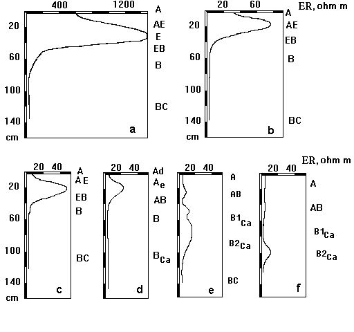
Fig. 2. Distributions of electrical resistivity measured with four-electrode probe along the soil profiles of (a) Typic Ferrudalf, Moscow area; (b) Typic Kandiudalf, Tula area; (c) Mollic Hapludalf, (d) Typic Argialboll, Kursk area; (e) Typic Calciudoll, (f) Xeric Calcigypsid, Herson area.
As the intensity of the elluviation processes decreased in the row of Ferrudalf-Kandiudalf-Hapludalf-Argialboll-Calciudoll, the differentiation of electrical resistivity in the soil profile vanished (Fig. 2). The distributions of electrical resistivity shown in Fig. 2 were measured along soil profiles in the open soil pits in different areas of Russia. Vertical electrical sounding conducted from the soil surface revealed the same profile distributions of electrical resistivity in Typic Ferrudalf as that obtained with four-electrode probe (Fig. 3, Fig. 2a). Therefore, by observation and interpretation of VES profiles we could obtain exact thicknesses and locations of soil horizons based on different electrical resistivities. The values of the electrical resistivity in E and B horizons have shown to be good indicators of intensity of the elluviation-illuviation process in soils.
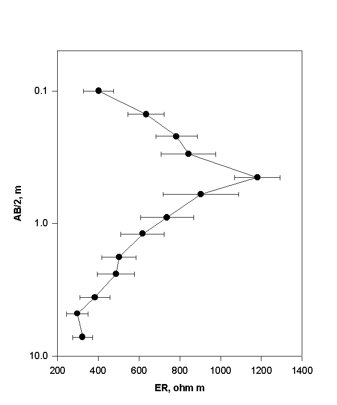
Fig. 3. Profile distribution of electrical resistivity in Typic Ferrudalf measured with VES method. The mean values with error bars are shown for 5 measurements on soils under native coniferous-deciduous forest in Kalinin area, Russia.
Therefore, the VES profiles aid soil surveying and mapping, especially in evaluating soils with highly distinguished profiles. Our investigations show a similar three-layer distribution of electrical resistivity within eluvial-illuvial soil profiles in a number of soils, such as Spodosols, Alfisols, Ultisols, and Oxisols (Pozdnyakov et al., 1996). In many other soil profiles, electrical resistivity variations in the layers are attributable to other soil-forming processes, pollution, or differences in parent materials.
REFERENCES
Arcone, S.A., D.E. Lawson, A.J. Delaney, J.C. Strasser, and J.D. Strasser. 1998. Ground-penetrating radar reflection profiling of groundwater and bedrock in an area of discontinuous permafrost. Geophysics. 63:1573-1584.
Austin, R.S., and J.D. Rhoades. 1979. A compact, low-cost circuit for reading four-electrode salinity sensors. Soil Sci. Soc. Am. J. 43:808-809.
Banton, O., M.K. Seguin, and M.A. Cimon. 1997. Mapping field-scale physical properties of soil with electrical resistivity. Soil Sci. Soc. Am. J. 61:1010-1017.
Barker, R.D. 1989. Depth of investigation of collinear symmetrical four-electrode arrays. Geophysics. 54:1031-1037.
Barker, R.D. 1990. Improving the quality of resistivity sounding data in landfill studies. In S.H. Ward (ed). "Geotechnical and environmental geophysics. V. 2. Environmental and groundwater applications". 245-251.
Beck, A.E. 1981. Physical principles of exploration methods. John Willey & Sons, NY.
Corwin, D.L., and J.D. Rhoades. 1984. Measurement of inverted electrical conductivity profiles using electromagnetic induction. Soil Sci. Soc. Am. J. 48:288-291.
Dohr, G. 1981. Applied Geophysics. Introduction to geophysical prospecting. In H. Beckmann (ed. Geology of petroleum, Vol. 1. Halsted Press, New York, Wiley Ltd., Chichester.
Fedinsky, V.V. 1967. Exploration geophysics. (In Russian.) Nedra, Moscow.
Freeland, R.S., J.C. Reagan, R.T. Burns, and J.T. Ammons. 1997b. Noninvasive sensing of near-surface perched water using ground-penetrating radar. Proceeding of the ASAE Annual International Meeting. Minneapolis, Minnesota. August 10-14. N 973073.
Freeland, R.S., J.D. Bouldin, R.E. Yoder, D.D. Tyler, and J.T. Ammons. 1997a. Mapping preferential water flow paths beneath loess terrains using ground-penetrating radar. Proceeding of the ASAE Annual International Meeting. Minneapolis, Minnesota. August 10-14. N 973074.
Halvorson, A.D., and J.D. Rhoades. 1976. Field mapping soil conductivity to delineate dryland saline seeps with four-electrode technique. Soil Sci. Soc. Am. J. 40:571-574.
Keller, G.V., and F.C. Frischknecht. 1966. Electrical methods in geophysical prospecting. Pergamon Press. Oxford, New York, Toronto, Sydney, Braunschweig.
Kirkham, D., and G.S. Taylor. 1949. Some tests of a four-electrode probe for soil moisture measurement. Soil Sci. Soc. Proc. 14:42-46.
Liner, C. L., and J. L. Liner. 1997. Application of GPR to a site investigation involving shallow faults. The Leading Edge. November. 1649-1651.
Matveev, V.K. 1974. Interpretation of electromagnetic sounding. (In Russian.), Nedra, Moscow.
Mazac, O., M. Cislerova, W.E. Kelly, I. Landa, and D. Venhodova. 1990. Determination of hydraulic conductivities by surface geoelectrical methods. In S.H. Ward (ed). "Geotechnical and environmental geophysics. V. 2. Environmental and groundwater applications". 125-131.
McBride, R.A., A.M. Gordon, and S.C. Shrive. 1990. Estimating forest soil quality from terrain measurements of apparent electrical conductivity. Soil Sci. Soc. Am. J. 54:290-293.
Parasnis, D.S. 1997. Principles of applied geophysics. Chapman & Hall, 2-6 Boundary Row, London SE1 8HN, UK.
Pozdnyakov, A.I., and K.Y. Chan. 1979. The technique of the electrical sounding and profiling in soil investigations. (In Russian.) Vestnik MGU 17. 1:46-54.
Pozdnyakov, A.I., L.A. Pozdnyakova, and A.D. Pozdnyakova. 1996. Stationary electrical fields in soils. (In Russian.) KMK Scientific Press, Moscow.
Pozdnyakova, L.A., A.I. Pozdnyakov., and L.O. Karpachevsky. 1996. Study hydrology of valley agricultural landscapes with electrical resistance methods. Proceeding of XXI Assembly European Geophysical Society, HS16 "The Hydrology of Small Agricultural Catchments", The Hague, Netherlands. 341-352.
Rhoades, J. 1979. Inexpensive four-electrode probe for monitoring soil salinity. Soil Sci. Soc. Amer. J. 43:817-818.
Rhoades, J.D., and J. van Schilfgaarde. 1976. An electrical conductivity probe for determining soil salinity. Soil Sci. Soc. Am. J. 40:647-650.
Rhoades, J.D., and R.D. Ingvalson. 1971. Determining salinity in field soils with soil resistance measurements. Soil Sci. Soc. Amer. Proc. 35:54-60.
Rhoades, J.D., P.G. Shouse, W.J. Alves, N.A. Manteghi, and S.M.Lesch. 1990. Determining soil salinity from soil conductivity using different models and estimates. Soil Sci. Soc. Am. J. 54:46-54.
Vanjan, L.L., and G.M. Morozova. 1962. Calculation of the theory curves of electrical sounding. (In Russian.), Gostoptehizdat, Moscow. Practical Geophysics, 34:135-144.
Verma, R.K., and T.K. Bandyopadhyay. 1983. Use of the resistivity method in geological mapping – case histories from Raniganj coal field, India. Geophysical Prospecting, 31:490-507.
Wilding, L.P., N.E. Smeck, and G.F. Hall (ed.). 1983. Pedogenesis and soil taxonomy. I. Concepts and interactions. Developments in Soil Science, 11A. Elsevier. Amsterdan, Oxford, New York.
Znamensky, V.V. 1980. Field geophysics. (In Russian.) Nedra, Moscow.