New Methodology for an Automatic Evaluation Procedure of Cadastral GNSS Measurements According to the Surveyors’ Regulations Instruction
Jad JARROUSH, Bishara KHELL and Marwan ZEIBAKA, Israel
SUMMARY
Cadastral points' coordinates in the national grid system will play the main role in the future Legal Digital Cadastre (LDC) system. It will be the main legal evidence in the court instead of physical evidence in the current analogical cadastre system. As a result, cadastral survey agency, which is responsible of maintaining the cadastral system, has to be worried about reliable coordinates' values which have to be saved in the cadastral database. Reliable values are those values with accurate properties which meet the instructions and the criteria of the surveyors' regulations.
This paper presents new methodology which is assimilated by software called MAJOR. This software is designed especially for executing an automatic procedure and evaluating the GNSS cadastral measurements via the surveyors' regulations criteria and instructions. The input of the procedure is presented and the patent of the new methodology is as well detailed. An example for GNSS measurements cadastral project is presented for more clarification. Finally, the paper highlights the role of the MAJOR software in building the LDC database in the near future.
INTRODUCTION
Transforming analogical cadastral system to modern Legal Digital Cadastre – LDC one, has became the ultimate goal for most of the worlds developed countries. LDC system principles have been firstly summarized by Kaufmann and Steudler in 1998. According to the digital cadastre, every cadastral parcel is defined by closed polygon consisted from boundary points. Every point is defined by grid coordinates of the national projection grid served the country.
The main principle of the LDC concentrate on the fact that the projection grid coordinates of the boundary point will play the main evidence in the court, instead of the physical wedge in the field. The LDC database will be based on those coordinates which are computed from licensed surveyors' cadastral measurements. Thus, the position accuracy of the cadastral points when marking them in the field, using their coordinates, should be executed in sufficient high level. Accuracy level for LDC purpose has been investigated by several authors over the world. In Israel, Steinberg in 2005 indicated a level of 5 cm as the ultimate level that the Survey of Israel (SOI) is looking for, in all over the country. Reaching this ultimate accuracy level needs a high quality national control network.
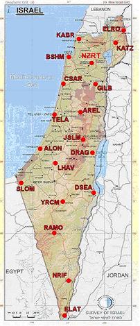
At the beginning of 2005 the SOI has been announced basing the two national grids of Israel, the horizontal and the vertical grids, on the Active Permanent GNSS control Network (APN) of Israel. The APN network consists of 19 GNSS points which are illustrated in picture 1, (Steinberg and Even-Tzur, 2005). The new control network projection is similar to the previous Transverse Mercator projection with the same parameters value of the previous "Israel Transverse Mercator" (ITM) control grid. The new grid is called IG2005 grid. Its inner announced accuracy level is 3 mm in 95% confidence level (Steinberg and Even-Tzur, 2005). According to Steinberg and Even-Tzur, 2005, it enables measuring cadastral points in any place in the country with 5 cm better accuracy level in relative to the APN points. In order to establish the future LDC database with 5 cm accuracy level, the SOI should design the Surveyors' Regulation and their instructions especially for this purpose.
Since the GNSS technology plays the main role for linking any new measured point to the APN control network, modern regulations instructions should concentrate on preserving high quality GNSS observations. GNSS observations' types are vary, for example: static postprocessing observations, RTK GNSS observation, Virtual Reference Stations' (VRS), methodology observation etc…
The quality assurance process of the GNSS observations types is a complex one, since the quality observations parameters are varied and related to several situations. The most significant influences are:
- Constellation of the satellites in the sky, position and number.
- Quality of the signals and the noises around the GNSS receivers.
- The distance between the receivers.
- The place of the receivers whereas there are objects that could affect the visibility to the sky or lead to multi-path phenomenon.
The first two influences are dynamic situations that could not be totally checked during the measurements. Thus, a great responsibility is imposed upon SOI shoulders when writing the future regulations and their instructions related to GNSS observation, for building the LDC database. Therefore, the future regulations' instructions and their quality assurance criteria might be more complicated as well as strict. This fact may affect the validation process of the cadastral measurements via the regulations' instruction and criteria process to become longer and more complex.
2. ISRAELI SURVEYORS' REGULATIONS STUDY CASE
Immediately, at the beginning of 2005, after the entrance of the IGD2005 control grid which is based on the Israeli APN network, the SOI has published a set of instructions which are explaining the measurements' methods for using it Stenberg, 2006). These instructions are published in the website of the SOI in http://www.mapi.gov.il/page.php?id=reg_inst , in Hebrew.
The most important instructions are:
- Instructions num. 1/2005, "Instructions for setting horizontal control points by using active permanent stations and virtual reference stations with formal transformation parameters": "http://www.mapi.gov.il/reg_inst/satl_geo.pdf
- Instructions num. 1-9/2007: "Updating and additions for the technical instructions of the manager": http://www.mapi.gov.il/reg_inst/tech-update-98-04-07.pdf
The main principles of the new instructions are:
- Direct measuring of the point using individual GNSS receiver from APN points or VRS point or VERS RTK Base point. In addition, using known and licensed control points in IGD2005 grid is permitted, taking into consideration more severe validation criteria.
- Checking the Calibration of the GNSS equipments of the surveyor using checkers points.
- Checking the accuracy of the new measured point in relative to the IGD2005 by requiring two independent GNSS measurements and calculating the distance value between them. Distance is computed by the IGD2005 coordinates difference of the points which are derived from every independent measurement session
- Independent GNSS measurement session is defined as new activation of the GNSS receiver and antenna on the new control point, when the antenna's height is changed more than 5 cm from the last session, and the difference time is more than a specific number of minutes.
- The IGD2005 control points are degraded into several levels in the horizontal positions and the vertical ellipsoidal heights (Steinberg and Even-Tzur, 2006). High levels required: long time of GNSS measurements, longer time difference between independent measurements session as well as small differences distance computed by two sets of coordinates in IGD2005 derived from every measurement session.
- The new regulation instructions of using GNSS measurements' technology describe the structure of the measurement net. The structure includes a description of the maximum and the minimum distances between the new points and the licensed points. The latter might be VRS, APN points or known as control points. Additionally, the structure includes the maximum and the minimum vectors' length in relative to the accuracy degree level of the new measured control point. Finally, in order to have high quality GNSS measurements results, the new regulations' instructions require preserving on DOPS values under 5. DOPS or "Dilution of Precision" is GNSS term used in geomatics engineering to describe the geometric strength of satellite configuration on GNSS accuracy (Langley, 1999).