
Creation spatial-geometric component of the electronic cadastre the slagheaps based on GIS and Internet technologies. Component of the electronic cadastre is a topographic base of slagheaps in shapefile format, in a coordinate system SC-42 in Gauss, attributes data, as well as 3D-models the slagheaps on example of the city of Donetsk.
Research and learning this problem is quite actual nowadays. slagheaps are the objects that take a special place in such areas of life and science as:
-Ecology and Environment (are ecologically dangerous objects);
-Land management and Land cadastre (it's necessary to know how to determine their boundaries and monitor changes);
-Industry (are the part of production process and may become secondary raw materials);
-Recultivation (slagheaps become zones of greening and afforestation) etc.
1. Systematization of information on the slagheaps in Donetsk using geoinformatic systems.
2. Delimitation of the slagheaps regards to Land management and Cadastre.
3. The creation of software, which converts the original file format kml to shp and recalculates the coordinates from WGS-84 to SC-42.
4. A scheme of translation coordinates from one coordinate system to another.
5. Creation three-dimensional models of the heaps.
Now Donetsk government is working on systematization all the information about slagheaps and developing electronic environmental maps. As reported in Management of Environmental Security: «The electronic maps will be created based on the popular Google search system. slagheaps will be located on the maps with such characteristics as height, date of formation and the other useful information. Moreover, new maps will give the information on green areas and water bodies of Donetsk (the source «Komsomolskaya Pravda») ». So now you can search all the Donetsk slagheaps on satellite maps, and not just visually, but also with detailed information about the «mountains of Donetsk».
The software Google Earth has been selected as a tool at this stage. Google Earth - is client software for working with three-dimensional model of the Earth, created on the basis of satellite picture. There are available opportunities to change the scale images (sometimes down to separate buildings) and many others, including determination the coordinates of the object.
The maps can be viewed from any angle; most of the maps - ordinary 2D-pictures, but some objects (settlements) are presented as three-dimensional models. It is a universal, available, simple, frequently updated application. The precision determination the coordinates accords to the task.
The advantages of remote monitoring:
– satellite images give homogeneous and detailed information about inaccessible areas with the same precision as for the well-studied regions, which allows using the method of extrapolation;
- instantaneity of the photos minimizes the influence of variables
weather and seasonal factors; the possibility of regular re-surveys
allows to select the best photos; dynamics of nature's processes is studied by the repeated surveys;
– opportunity to study the complex processes;
– recognizing the morphological features the structure of landscapes and man-made structures at high-resolution images.
The contour base was created by software Google Earth. The slagheaps have been deciphered on satellite images. Each slagheap was marked by a label and the boundaries were marked by polygons. The unique number was assigned to each object and landmarks of location were pointed.
Total there are 128 slagheaps in Donetsk, about 90 ones were recognized.
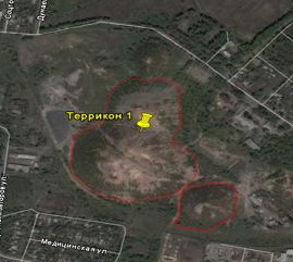
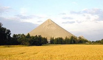
Image 3 shows three-dimensional look at slagheap on Google Earth.

Information about the polygons is contained in KML-file created during working with Google Earth.
КML or Keyhole Markup Language is the XML grammar and file format for modeling and storing geographic objects such as points, lines, images, polygons, and models for displaying in Google Earth, Google Maps and other programs. KML can be used to exchange labels and information with other users of these programs. Like HTML, KML language structure is based on tags with the names and attributes that are used to achieve certain objectives in view. KML-files are usually distributed in ZIP-archive: KMZ.
For each object (slagheap) the main GIS features are given:
- geodesic longitude;
- geodesic latitude;
- height above the sea level or above the Earth's surface level;
- visual features (color, shape, thickness, size, label, etc.);
- brief description of the object (which later displayed in the tooltip on the user's request)
It may also be the recommended angle of observation for marked place (that is the recommended height), azimuth and angle of «virtual camera».
Google Earth uses a coordinate system WGS-84, so we have to get a topographic base in a coordinate system used in our country. The coordinate system used in our country is SC-42 (in Gauss). Conversion coordinates from WGS-84 to SC-42 is realized in several stages:

1) Translation the geodesic coordinates in WGS-84 to the rectangular coordinates in WGS-84
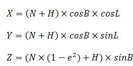
2) Translation the rectangular coordinates in WGS-84 to the rectangular coordinates in SC-42
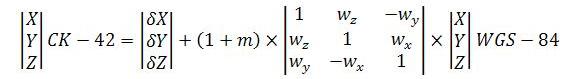
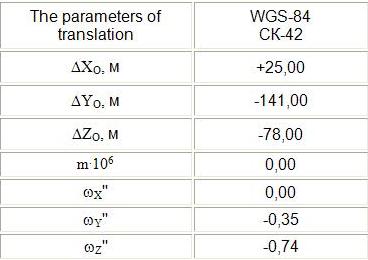
At this stage we use the parameters: displacement on axes, the angles of rotation round the axes, scale factor.
Below are the approximate parameters of the transition between systems WGS-84 and SC-42. Below are the parameters of the translation between systems WGS-84 and SC-42.
3) Translation the rectangular coordinates in SC-42 to the geodesic coordinate in SC-42
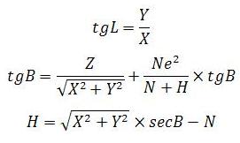
To calculate the latitude with the precision of 0.03'' we make three iterations.
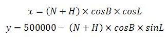
4) Translation the geodesic coordinates in SC-42 to the plane rectangular
coordinates in SC-42 in Gauss
The task of creation a topographic base was realized in object programming environment, Delphi. Implementation steps:
1. Open the file in KML format.
2. Reading and translation coordinates.
3. Formation shapefile with new coordinates.
Reading and processing of KML-file was performed with component SVO GIS (Shape Viewer Objects) - free for commercial use library for creating GIS. We can extract coordinates from the KML and create shapefile by this component. It is free to use and is provided with source code. SHP format has been selected to store the information. This format is one of the most popular spatial data formats for description the characteristics of the Earth's surface. Shape-file - is a homogeneous set of spatial objects (point, multipoint, polyline or polygon).
Each object in a shapefile represents single geographic entity with its attributes. The geometry of the object is stored as a shape, which contains a set of vector coordinates. Shapefile consists of three files: the main file, index file and table dBase. The main file is a file of direct access with the extension SHP. It contains spatial data (records with a list of vertex). The index file has the extension SHX. DBase table has an extension DBF and includes attributive information about the objects or its attribute keys.
Advantages of SHP format:
1) shapefiles do not contain topological superstructure;
2) faster rendering and ability for editing compared with other data sources;
3) shapefiles work with objects, which can overlap or do not touch;
4) requires less disk space and are easier for reading and writing;
5) shapefiles support editing data using ArcView GIS, what is important for future monitoring of the slagheaps;
6) polygons must be submitted as closed figures (as the slagheaps are represented);
7) attribute data are contained in dBase format (that is convenient for storing attribute information and its further use in databases).
1. KML-file with the information on slagheaps: coordinates (geodesic latitude, geodesic longitude and height) of boundaries the slagheaps in WGS-84; attributive information (location).
2. SHP-file with the information on slagheaps: coordinates of boundaries the slagheaps in SC-42 in Gauss.
3. The creation 3D models of the slagheaps is planned.
The master's work hasn’t been finished yet while this author’s abstract was written. The final version is planned on December 2010. The whole text and materials on the master's work or data concerning this topic are available from the author or the scientific adviser after the stated day.