ENG | UKR | RUS | DonNTU > Master's portal DonNTU
Master DonNTU Matlaeva Inga
Matlaeva Inga

Мining-geological Institute

The Mine surveying Department

Speciality: «Mining Surveying»


Theme of master's work:

«Development and introduction in the educational process of passport of educational surveyor polygon with the mathematical analysis of its parameters».

Scientific adviser: Mirnyi Viacheslav


Materials on the theme of master's work: Main | Library | Links | Search report | Лучше самая малая помощь, чем самое большое сочувствие

Abstract


Сontent :

1. Introduction

1.1 Actuality of the topic

1.2 Aims and tasks

1.3 The main idea and the object of research

1.4 The scientific innovation and practical using

1.5 Subject and method of research

2.The main content of the work

3.Consclusion

Bibliography

1. Introduction

1.1 Actuality of the topic

The main aim of the orientatively connective survey is to realize geometrical connection of the planned surveys on the earth surface and in the underground mining surface. As a result of such kind of surveys has to receive coordinates of the first point of the underground network and the directional angle of the first side.

The magistracy work is done due to Mine Surveying Faculty.

1.2 Aims and tasks

The aim of this work is an exact survey of educational polygon with its next etaloning and development of passport of educational surveyor polygon for using in the educational process of Mine Surveying Faculty students.

There are several main tasks of investigation:

1. to improve using laboratory equipment which was development before.

2. to develop formulars and schemes of executing separate kinds of mine surveys which correspond to parameters of polygon.

3. to execute etalon surveys of the parameters of polygon.

4. to investigate all possible variants of executing separate kinds of work and to base argument on optimal schemes accommodation of equipment and doing surveys.

5. to execute investigation of exactness separate elements of polygon and to value correspondence of polygon to normative mine surveying documents.

6. to complete passport of the polygon in suitable for using form.

1.3 The main idea and the object of research

The main idea of this work is to create the imitation of fulfilling mine surveys for building of strong point nets, the most approaching to the real conditions. The object of research is the method of executing in the educational conditions of the process executing mine surveys.

1.4 The scientific innovation and practical using

There isn’t such kind of at our university. Creation and involving it into the educational process will improve and make easer education of the students of mine surveying Faculty. That’s why I think it is possible to put this work in the sphere of scientific innovation. I this work is practically useful.

1.5 Subject and method of research

The subject of research is a system of points, fixed on the Mine surveying Faculty. This Faculty is situated in the Eleventh Educational Building and forms the educational surveyor polygon

2.The main content of the work

The educational polygon is situated on there floors of the Eleventh Building of DonNTU. Trunks are situated in the Northern and Southern End. The staircase leads to the northern emergency exit.

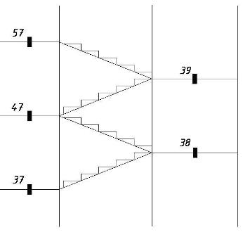
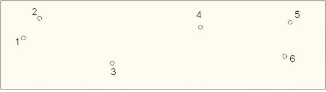
There are several strong points on the second (third) floor and in the ground (floor). The scheme of situation strong points on the third (tourth) and fourth (fifth) floor has the similar construction. The schemes of situation strong points on the 3 and 4 (5) floors are in the picture 1.1 (a, b). There are also strong points on the stair ways between the 3 and 4 and 5 floors (picture 1.2).

Picture 1.1(a) – Scheme of situation strong points of educational of polygon
Picture 1.1(b) – Scheme of situation strong points of educational of polygon
Picture 1.1 – Scheme of situation strong points of educational of polygon.
Picture 1.2 – Scheme of situation strong points between stair ways.

Highly exact angle and linear surveys were made on all strong points.

Picture 1.3 – Scheme of measuring angles by the way of circular method.
Graphics: file size - 78,2Kb, the number of cadres - 8, the delay between cadres - 300 ms, the number of cycles of repetition - not limited.

The next step is the whole row of the work geometric orientation across one trunk. Orientatively connective survey across one vertical trunk includes:

1) protection of two points from the surface into the mine;

2) adjoining to these points on the surface and to their proections on the horizont of mining work;

3) calculation.

3.Consclusion

On the given stage my magistracy work doesn’t complete. The great volume of surveys was done. There next task for me is to execute all the cameral surveys according received calculation and to compare they with requirement of the mine surveying instructions. After that I have to do the mathematical analys of exactness of angle and linear parameters of the polygon, their conformity to normative mine surveying documents. And also I have to develop formulars for recording all the students surveys during laboratory work. To complete the status of educational polygon I have to develop its passport and the Mine Surveying Faculty would confirm it.

Bibliography

1. Оглоблин Д.Н., Герасименко Г.И., Акимов А.Г. и др.Маркшейдерское дело: Учебник для вузов/ – 3-е изд. перераб. и доп. М., «Недра» 1981. 704с.

2. Инструкция по производству маркшейдерских работ/ Министерство угольной промышленности СССР, Всесоюзный научно-исследовательский институт геомеханики и маркшейдерского дела. – М.: Недра, 1987. 240с.

3. Маркшейдерские работы на угольных шахтах и разрезах. Инструкция: Киев., 2001 – 264с

4. Гудков В. М., Хлебников А.В. Математическая обработка маркшейдерско—геодезических измерений: Учебник для вузов. – М.: Недра, 1990. – 335с.

5. Попазов М.Г., Могильный С.Г. Теория ошибок и способ наименьших квадратов: Учебник для вузов. – М.: Недра, 1968г. – 302с.

6. Капланець М.Є. (голова) та ін. Маркшейдерські роботи на вугільних шахтах та розрізах/Інструкція – Доецьк: ТОВ «АЛАН», 2001. – 264 с.

7. International Society for Mine Surveying. XIII International Congress. Budapest, Hungary, 24-28 September 2007. – 569с.


DonNTU > Master's portal DonNTU | Main | Library | Links | Search report | Лучше самая малая помощь, чем самое большое сочувствие

Inga Matlaeva © Donetsk 2010