 |
|
|
Home Synopsis Library References Search report Solo section |
RUS| UKR | ENG || ÄîíÍŇÓ > Master's portal DonNTU 
Prokopenko AleksandrMining and geology instituteSpeciality: Mining surbeyingContents of : -the basic idea and the object of research -scientific novelty and practical utility Mining in Ukraine, and in particular the mining work, which includes coal extraction under the built-up areas. Cleaning extraction of these resources leads to subsidence deformation of the Earth surface and harm to buildings and structures located on the weal territory. Therefore, the operational forecast of the displacement, strain and assessment of the injury are important for mine planning and action protection of objects on the Earth's surface. To automate the calculations of displacement and deformations of the earth's surface from the influence of underground sewage extraction developed some software. But a significant amount of graphic works related to these calculations by hand and takes time. Therefore, automation establishment of mining and graphic documentation in predicting subsidence and deformations of the earth's surface is relevant and important scientific and technical challenge. The aim is the creation software for the automated construction of graphical documentation in predicting the displacement and deformation of the earth's surface from the influence underground cleaning extraction, which will enhance timeliness and accuracy of this forecast. The basic idea and the object of research he idea of work is to use the capabilities of modern computer systems, computer graphs for automated programming of the graphic documentation forecast displacement and deformation of the earth's surface. Scientific novelty and practical utility Will be enhanced computer technology forecast subsidence and strains the earth's surface from the influence of underground sewage extraction, increased efficiency and accuracy of this forecast. The software will be used when drafting underworking buildings underground mining. The first part of creating software is a database in Microsoft Excel. The database includes information-gathering data on the lava: 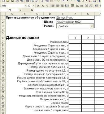 Picture 1 - Data for lavas in Microsoft Excel After compiling a database on lavas used the code using Visual Basic in Microsoft Excel. This phase of the program involves the delimitation of zones of influence of mine workings under the "Rules underworking buildings, structures and natural facilities for coal mining by underground methods, the calculation of boundary angles: Beta0, Gamma0, Delta0, Fi0, Delta0m; Points total subsidence: Ksi1, Ksi2, Ksi3; Angle of maximum subsidence Teta; Points subsidence: Beta, Gamma, Delta, Fi, Deltam. The next step is to create zones of influence of mine working on the vertical cuts: across the trend of formation; on strike. To do this, we associate a database of lavas in Excel c AutoCAD, c using Visual Basic. 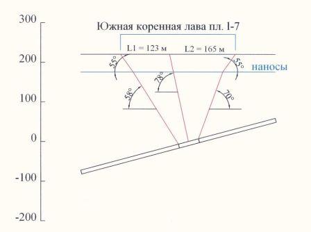 Picture 2 - The zone of influence of mine working across the strike 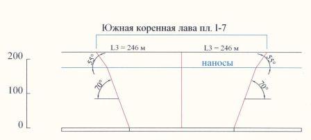 Picture 3 - The zone of influence of mine working on the strike The last step is the application of the electronic plan of mine workings smoothed contour lava zones of influence basin subsidence and collecting digital information on the relief surface, buildings and structures, which fell under the influence of sewage generation. 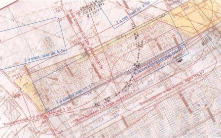 Picture 4 - The border zone of influence of the 1 st southern lava layer l-7 sh.Rodinskaya with the location of calculation points 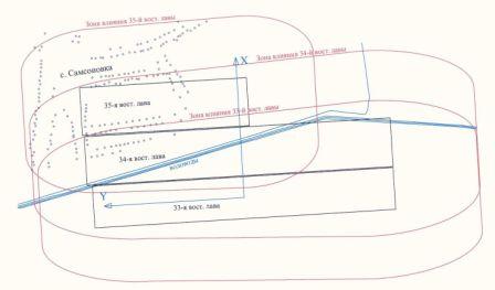 Picture 5 - The boundaries of zones of influence of the 33 th, 34 th, 35 th Sun. Lave u. Molodogvardiis'ka with the location of calculation points In the master's work represented an actual scientific and practical challenge of development automate the creation of mining and graphical documentation in predicting the displacement and deformation of the earth's surface. Today is the creation of automated building: the basin, a zone of influence (transect and along the strike) with the code Visual Basic. In the future we plan to develop an automated collection of digital information from mining and graphic documentation.  Important When writing this author's abstract work is not yet completed. The final completion of the work: December 2010. Full text of the work and materials on the topic can be obtained from the author or the head after that date. |