Developments of the 3D Cadastre in Norway
Tor VALSTAD, Norway
Key words: 3D Cadastre, subdivision, underground property, construction parcel
INTRODUCTION
Land has traditionally been described and registered in two dimensions. Accordingly all cadastral systems of the world are in fact two-dimensional. There is an increasing demand for space in the worlds built up areas and both space above and below the surface are being utilised. The cadastral systems should therefore reflect the actual situation and not only the surface parcel.
This need to register ownership to volumes has been solved differently in various countries. In most cases the actual volume is not registered as a separate entity, but is linked to the surface parcel in a descriptive way for example by an easement. For many countries this is not sufficient any more, as the owners of the 3D structures might not be the same as the surface parcels. They want their ownership registered in a proper way as constructions above or below ground usually are quite expensive.
Though the registration of land in Norway has been regulated since the thirteenth century, it is only after the Land Subdivision Act came in 1978, that the whole country has the same identification system for properties. The Land Subdivision Act covers the whole country, but deals only with two-dimensional properties. This made it difficult to identify and register underground structures in a way that satisfied the Land Registrar. In 1987 the Municipality of Oslo developed, in cooperation with the Land Registrar, a cadastral system that could handle three-dimensional objects.
THE OSLO METHOD
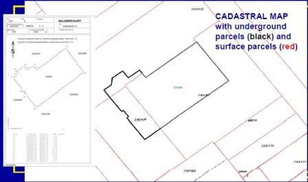
All land in a municipality is divided into fixed number of large areas, which each is given a main registration number. These areas are then subdivided into parcels and numbered in succession by a parcel number. Within a municipality a parcel is uniquely identified with an area and parcel number, eight digits in all. On a national level four more digits are added to identify the municipality.
The City of Oslo is divided into approximately 250 areas. An underground parcel is given the same area number as the parcel on the surface, but with 300 added. The parcel number starts at one. This gives each underground parcel a distinct identification and with a relationship to the surface property as well. Area numbers from 601-900 are reserved for parcels above the ground.
Procedure
The Land Subdivision Act regulates both the survey work and the administrative routines of the subdivision process that is required to have a new parcel properly identified. The whole process is a municipal responsibility. Private companies can do part of the process, but since every municipality has its own surveying unit, it is not very common. The new law on cadastre will partly end this municipal monopoly as it opens up for private surveyors from licensed companies.
The Land Subdivision Act regulates both the survey work and the administrative routines of the subdivision process that is required to have a new parcel properly identified. The whole process is a municipal responsibility. Private companies can do part of the process, but since every municipality has its own surveying unit, it is not very common. The new law on cadastre will partly end this municipal monopoly as it opens up for private surveyors from licensed companies.
Underground parcels
The subdivision of underground parcels follows partly the same procedure as for surface parcels. The titleholder on the surface has to agree to give up his rights to the underground. In Norway there has not been established a finite depth of ownership.
But usually ownership downwards has been accepted as far as you are able to utilise it. Which means that private landowners outside the central business district are seldom compensated for tunnels under their property, even if only 10-30 metres below the basement. Acquisitions of underground areas for public tunnels are usually done by occupation. In a few cases underground areas have been expropriated and compensated because of future restrictions of the landowner's possibility to build below the ground. When a national or municipal agency is involved in underground construction, the finished volume is seldom subdivided from the surface parcel. If it is necessary to reach an agreement with the landowner, a restrictive clause will be added to the title deed of the land at The Land Registrar.
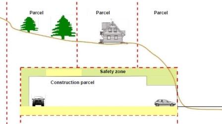
Example of the "construction parcel"
To establish a 3D parcel you have to get a building permit which is valid for three years. A 3D parcel in Norway cannot be established without something being built or it has to relate to an existing construction. There is not any possibility to register volumes of air or rock just to confirm your ownership or to reserve the volume for future use. Neither is it possible to establish a 3D parcel independently from the surface parcel. The surface parcel is the main property object and “construction properties” are only limited volumes connected to the surface parcel though they can be connected to multiple surface parcels.
3D cadastral surveying
The application process is similar to surface subdivisions, but the cadastral surveying is somewhat different.
It is of course impossible to set out the desired underground area beforehand so we are reduced to accept the plans and drawings from the applicant. Usually we accept the drawings as the final result and issue a survey certificate without any surveying. The section for cadastral surveying employs a reflectorless total station and many underground parcels are now surveyed both at the bottom and at the top, such that the underground parcels are identified as exact volumes. On the survey certificate, each corner is given coordinates and heights at the floor and at the ceiling. The registration number and the survey identify the parcel as a volume, but in the various registers the parcels size is given in square metres and not in cubic metres.