EN

Brilyova Irina
Faculty of Environment and Chemical Technology
Minerals and еkological geology department
Speciality "Environmental geology"
Impact on the safe life of tectonic structuresScientific adviser: Korchemagin V. |
Topicality of the work
Environmental conditions of life on the mine field depend largely on the tectonics of the underlying solids. Studying of field’s deformation allows detecting areas of stretching to which the outlets of gas, groundwater are associated, on which depends the safe vital activity
The purpose of work is studying of the influence of tectonic breaks on the vital activity of man.
Main research tasks
- to analyze the current state of scientific problems master’s work on international and domestic literary sources;
- to explore the features of the tectonic structure of the field of mine "A.F. Zasyadko "in light of the study of the problem;
- to conduct a study of grooves of slip on the field of mine ".A.F. Zasyadko;
- studying of the kinematic method, in which the identification of zones of tension and prediction of gas traps are made;
- trace the influence of tectonic structures on safe living of man;
- to detect dangerous to human life tectonic zone;
- comparative evaluation of received characteristics of the studied object with the similar objects in order to use received findings to other objects;
- to develop a set of recommendations, preliminary studies and activities to optimize the forecasting of coal thickness’s gas–bearing.
Object of research a field of mine "A.F. Zasyadko"
Subject of research is the tectonic structure and field of deformation of the field of mine "A.F. Zasyadko ", their connection with gas sources and their impact on the safety of human life.
Methods of research:
- measurements of slickensides in mine productions and on the surface of a mine field;
- kinematic method for constructing the deformation field and defining zones of stretching;
- methods of spatial analysis;
- rationale of results in the environmental field.
Scientific novelty
- Selection of massif’s zones of stretching, which are accompanied by high gas content.
- Prediction of gas out’s impact on the livelihoods of people.
For the first time connection between the output of gas to the surface and tectonic structure of the area was identified and due to this adverse effect on human was determined.
Practical significance
Defining zones stretching massif will identify areas of high gas content and, therefore, identify areas of possible sudden release of gas.
Personal contribution of the author
I studied slickensides, constructed the deformation field, made maps of spatial analysis and identified the effect of zone stretching on the safe life of man.Analysis of state scrutiny of the question
In general, the tectonic structure of the Donetsk–Makeyevka coal–bearing area is fairly well understood at example of the Donets Basin.
Long–term studies in the exploration and exploitation of coal deposits of the Donbass made it possible to characterize regional patterns of its tectonic development with sufficient details. In this regard, should be noted the work aimed at studying the regularities of distribution of tectonic faults.
So that at the end of XIX century – beginning of XX, the existence of chain of the breaks on superlevel for Donbass was set by A.P. Karpinski (1888) who has allocated large blocks of earth crust separated by a zone of tectonic disturbances.
Kozlov S.S. in his work devoted to the rules of distribution of small–amplitude disturbances in the sediments of the Donets Basin defined that the zone of small–amplitude disturbances have a width of 600–900 m and are characterized by sublatitudinal stretching.
L.I. Pimonenko established a multiplicity of distances (3–6–12 km) between middle–amplitude overlap faults of the sedimentary cover along the stretch of the main anticline Donbass.
Bogachenko NN identified the system in the development of fractures and low–amplitude faults of tear on explored areas and active fields of mines of Donbass.
Blocks of rocks that have regular geometric shapes, with sizes from hundreds to several thousand meters in the Donets Basin Carboniferous were allocated VF Prihodchenko.
According to these authors, in nature there are almost no single crack, they tend to form a system. Typically, in the array of rocks there are a number of systems that intersect at different angles to form individual blocks.
On a more local level tectonic fields were studied by such academics as Korchemagin V.A., Shamayev V.V., Pavlov I.O.
The aim of this work is to study the tectonic fields in the field of mine "A.F. Zasyadko" and to detect the effect of the gas output to safe human life. At this level the problem is poorly studied.Geological structure of the subsoil on the area of research object
The stratigraphy and lithology
Within the field of mine “A.F. Zasyadko” coal–bearing thickness is composed of sediment formations of middle carbon. Middle carbon sediments represented mudstone, siltstone and sandstone in an almost proportional relationship with the minor amounts of limestone (0,3 – 3,4%) and coal (3,5 – 7,5%), and in the cut sandstones are characterized by the greatest variability of power in comparison with the constancy of the rest rock complex that is associated with facial conditions of formation of sedimentary carbon. With stratigraphic depth to the lower of the Moscow stage, a slight increase in sediment content of sandstone is seen (from 25% in Gorlovka formations up to 36% in Kamenka formations).
Upper сarbon sediments are deposited according to the middle carbon sediments and characterized by a sharp decrease of coal content, by the presence in cut powerful layers of red clay ("pestrotsvetov"), that are good confining beds, and powerful layers of sandstone. The power of upper hard coal deposits varies depending on location and ranges from a few hundred meters to 1,000 meters or more.
Carbon sediments overlap thin (up to 50 m) quarternary clays, sandy loams and sands, sometimes paleogene sands, the highest power of which is dedicated to the axial part of Vetka flexure.
Structural and tectonic characteristics of a mine field
The field of mine A.F. Zasyadko is conjunction with to the central part of the Donetsk–Makeyevka area and is characterized by extensive development of multiplicative structures (flexures), less disjunctive and, then, multiplicative structures of higher order.
Stretching of the coal–bearing thickness is sublatitudinal and near Vetka flexure is changing to north–east. Dropping of rocks on the north, north–east has angles 5–14 grd, in the flexure area angles of incidence reaches 30–40 grd.
The field of mine A.F. Zasyadko is located in the hanging wing of the regional French thrust between the two flexural folds – Vetkovskaya and Chaykinskaya(pic. 1.1) Both are accompanied by tectonic flexure – Vetkovsky (№ № 1–4) and Grygoryivsky thrusts accordingly. Vetkovsky thrusts have north–west drop with dip angles – 70–60–30 grd, Grigorievsky – dip azimuth 300–330 grd, dips 22–55 grd, mostly – 25–30 grd.
The presence of flexural folds complicate the general south–west stretch of Carbon rocks, and it varies between flexure and extends mainly to the southeast, taking the folded shape with the fall of coal layers in the north–west and north at angles of 3–4 grd to 12–15 grd. In the area of Vetkovskaya flexure angles falling reaches 25–40–60 grd, the amplitude varies from west to east from 600 to 300m. Chaykinskaya flexure has more gentle dip angles –25–40 grd and vertical amplitude of up to 400m.
The field of mine is a weakly expressed syncline fold, bounded by named above flexure. North–west wing of the folds is omitted, the south–east is elevated. On the wings of this fold plicative structures of the second and third order, an alternation of local positive and negative structures, revealed by trend–analysis of the structural planes of coal layers and sandstone, are formed.
The field of mine A.F. Zasyadko, in addition to regional disturbances contouring mine field around the perimeter (the technical boundaries) and described above, is characterized by low–amplitude disturbance, developing through the coal mine field uneven.
Small–amplitude disturbance is fixed only in mine outputs and is not determined by geological exploration because of minor amplitude (rarely exceeding 2.0 m).
The west wing of the mine field is omitted; small–amplitude disturbance is highly developed there. Mining operations on the seams and m3 l1 on the western flank of the mine fields marked thick (~ 150 m wide) zone of low–amplitude disturbance, stretching to the north–east direction with dips 20–25 grd and the amplitude of the displacement of 0,5 m to 1,75 m. A distinctive feature of this zone are high reservoir properties that, having confining beds in the upper part of the section and high gas saturation thickness at deep levels, led to the formation of tectonic trap of free gas in the coal–bearing thickness. Autopsy of this trap leads to repeated filling of mine working by gas on layer m3 at different depths and accidents in connection with the explosions of methane. By analogy, we can predict that all zones of small–amplitude disturbances in the coal–bearing thickness of the mine A.F. Zasyadko at depths of 1,000 meters or more can form a similar tectonic (more structural–tectonic) traps with free methane and their opening by mine workings should be carried out with pre–degassing, and other activities, able to decontaminate such clusters.
Elevated is characterized by lesser tectonic disturbances and great development of multiplicative structures – the local positive and negative revealed by the trend–analysis of the structural position of the horizons of coal and sandstone. But the raised position of the wing against the whole mine field because of its discrete structure (as mentioned above) caused higher gas saturation of the coal–bearing thickness and the formation of structural–granular traps of free methane. Confirmation of this position can be gas filling of 13th on eastern lava formation l1 that happened on September 20, 2006.
A more detailed description of the modern tectonic setting and the state of the mine field is given below. Paleointensity reconstruction tectonic, dynamic state based on measurements made in mine outputs (in this work) and analysis of geological documentation that accompanies of mining operations.
Methods of research
Description of the factual material
The whole number of measured slickensides in mine outputs and mine on the earth's surface in 15 observation points is 200.
Methods
In material processing and the interpretation of results was used computer programs developed in the GIN RAS, Donetsk National Technical University, Institute of Physics of the Earth Sciences and the Moscow Geological Prospecting Academy.
To construct the deformation fields a computer program GEOS was used. It is was designed by Gushchenko O.I., Mostrikovym A.A.
GEOS is program of the kinematic analysis of slickensides. It is used to estimate the parameters of the deformation field, which caused the formation of all gaps in the mine field.
The main parameters of the deformation field are:
- orientation of principal normals of deformation ellipsoid of deformation. This are є1, є2 , 3.
- Lode–Nadai coefficient (мє), which reflects the ratio equal to 2 *( є1– є2/ є1– є2)–1, varies from 1 to +1. negative values indicate the blocks stretching, positive–grip.
- Z–component, which reflects the projection of the vertical axis of the ellipsoid of deformation on the vertical. The value of Z–components of less than 1 corresponds to areas that feel lowering at the time of deformation, over 1 – uplift.
After receiving the results of GEOS with the help of program Excel sampling of values of the coefficient Lode–Nadai – Meps and the relative magnitude of the vertical component of deformation ellipsoid (z–component), that were used for further studies.
For mapping the distribution of values of parameters was used the software package Surfer, which will clearly displayув the digital information (the distribution of values of the Lode–Nadai and z–component of the field of mine A.F, Zasyadko).
Expected results
In the course processing of experimental data following cards have been built:
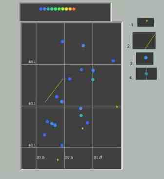
- map of the points of made observations (Fig. 1)
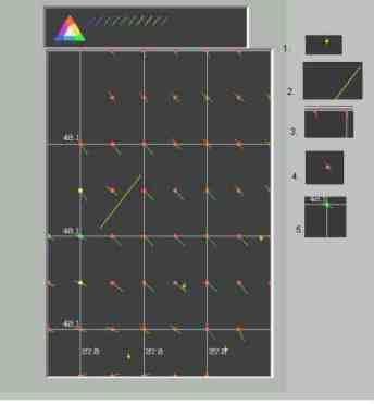
- position of the axis of compression the deformation field of smoothed type (Fig. 2)
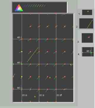
- the position of the intermediate axis of the deformation field of smoothed type (Fig. 3)
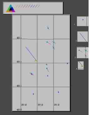
- position of the axis of compression the deformation field of not smoothed type (Fig. 4)
On the maps of deformation ellipsoid red points represent “throwing out” field type deformation (є3 subhorizontal, є2 subhorizontal, є1 subvertical). The point of blue color indicates the fault type of deformation field (the opposite position of the axes of the ellipsoid). Point of the green is the shift type of deformation field (є3 and є1 subhorizontal). Color of the arrows shows the value of the coefficient of Lode–Nadai: blue – less than 1 (elongation zone), red – more than 1 (compression zone).
Fig. 1. Map of the points of made observations Fig. 2. The position of the axis of compression the deformation field of smoothed type Symbols:
- shafts;
- axis flexure;
- the point at where measurement was less than 10;
- the point at where was more than 10 measurements;
Symbols:
- shafts;
- axis flexure;
- stretching band;
- throwing out type of the deformation field
- shift type the deformation field
Fig. 3. Intermediate axis of deformation ellipsoid Fig. 4. Position of the axis compression of deformation ellipsoid of not smoothed type Symbols:
- shafts;
- axis flexure;
- stretching band;
- throwing out type of the deformation field
- shift type the deformation field
Symbols:
- shafts;
- axis flexure;
- stretching band;
- throwing out type of the deformation field
- shift type the deformation field
The studies were conducted kinematic method. For this deformation field was constructed, stretch zone for projected gas traps were allocated detailed study of the tectonic structure in process of detail study of the tectonic structure.
These areas are located in the extreme northern and southern parts of the mine field, and region of stretching is located in the central part according to single observation. Thus, in these areas, there is the prospect of formation of gas traps.
Stereogram (Fig. 5) represents the image of the pole sliding slickensides, all which are on mine field with a displacement vector. There is a circular distribution of slickensides. Angle of incidence of slickensides is 45 grd. Within the circle thickening is allocated in the direction of NW–SE and NE–SW. Displacement vectors are dominated by thrust nature
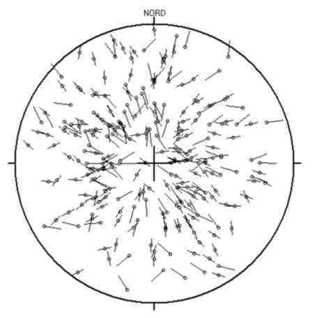
Fig.5. – Stereogram of slickensides
References
- Геология месторождений угля и горючих сланцев СССР.– М., 1963г.
- Лужецкая Л. М. Геологический отчёт о доразведке и переоценке запасов каменных углей поля шахты им. А. Ф. Засядько производственное объединение “Донецкуголь”(подсчёт запасов по состоянию на 1.07.88г.) в книгах и папках.
- Бобрышев В.В. Газоносные структуры шахтных полей: выявление, дегазация, освоение, прогнозные запасы. Академия горных наук Украины, Донбасский научный центр. Сборник материалов заседаний НТС.1995.
- Геологические основы методики изучения и прогнозирования газоносности вмещающих пород угольных месторождений. ИПКОМ. 1966.
- Лукинов В.В., Пимоненко Л.И. Тектоника метаноугольных месторождений Донбасса,–Киев: Наукова думка, 2008
- Методические указания к лабораторным работам по курсу «Специальные методы в геологии» для студентов специальностей «Геологическая съемка, поиски и разведка полезных ископаемых» и «Экологическая геология» – Донецк, ДонНТУ, 2007р. – 18 с.
- Корчемагин В.А., Павлов И.О. Поля напряжений и деформаций и выбросоопасность углей и пород Донецко–Макеевского района Донбасса
- О.А. Карамушка Анализ параметров тектонических блоков, выделенных на территории Красноармейского, Донецко–Макеевского, центрального и Луганского геолого – промышленных районов. [электронный ресурс]. – Режим доступа: http://www.nbuv.gov.ua/portal/natural/Geotm/2009_81/13.pdf
- Сим Л.А., Корчемагин В.А., Рапопорт А.Б. Значение тектонофизических исследований в решении практических задач [электронный ресурс]. – Режим доступа: http://www.scgis.ru/russian/cp1251/h_dgggms/1–2008