The purpose of Thesis is obtaining of standard geodesy and mine surveying site, which by its structure and accuracy would correspond with all set requirements. The research tasks are the following: a) field reconnaissance and selection of areas for laying of points centers of sites; b) direct laying (concrete lining) of points centers; c) performance of necessary works on preparation of high-precision measuring devices and instruments; d) conduct of field observations on the created site; e) processing of measurements and equalizing calculations f) appraisal of measurements accuracy and inspection of site conformity with due requirements.
Concept of Thesis and target of research
Main concept of Thesis is to create reference site for the Chair in order to build triangulation, trilateration network and closed leveling lines.
Target of research is methodology of performance of field observations in order to create high-precision network during the practice on Higher Surveying.
Scientific novelty and practical relevance
As was said above, our University doesn’t have such site. Its creation and involvement into academic activity will improve and simplify considerably studying of students on Mine Surveying specialty in discipline “Higher Surveying and Fundamentals of Photogrammetry”, therefore, in my opinion, such Thesis may be referred to the field of scientific novelty and considered to be practically useful.
Subject and method of research
Subject of research is created system of points, fixed on the tops of mountain heaps, located not far from premises of Mine Surveying Chair, which form reference training geodesy and mine surveying site.
Summary of subject research at Donetsk National Technical University
Donetsk National Technical University doesn’t have such site.
Works on creation of site were conducted together with my groupmate Salashny D., part of these works was included into the Special Section of Specialist Graduation Project.
Summary of subject research in Ukraine
Publications of such work performance were not found in Ukraine.
Main contents of works
Works began from planning of project of high-precision site for geodesy and mine surveying research. During this planning there were made the following requirements:
- all points should have intervisibility among themselves;
- the site will be used for the long time, therefore, all points should be rigid and reliable;
- as points centers should be supported by altitude basis, its structure should enable to use them as monumented bench mark;
- as points can be used in work with GPS or GLONASS navigation system devices, there should be provided open horizon visibility from each point during 300 minutes.;
- in order to receive sufficiently exact value of angular dimensions according to the data of calculations, its linear elements should be defined with inaccuracy, which doesn’t exceed 5-8 mm;
- the surrounding area should provide, in the future, ability to build up planned first stage of site.
Preliminary reconnaissance proved ability, in order to perform stated requirements, to use old mountain heaps as areas of laying. Use of these dumps was stopped about 50 years ago, filled up rock turned to be solid mass, and in several places it hardened into stone mass due to the past chemical reactions and internal burning.
Thus, points centers of site are located on the tops of mountain heaps (dumps) nor far from premises of Mine Surveying Chair. Layout of points is given on Figure 1.
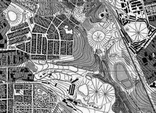 Figure
1 – Layout of location of points centers of site
Figure
1 – Layout of location of points centers of site
For each point there were excavated 0,6 м, depth pits, and 0,8 м long metal core with welded stainless steel upper part, which has 7 мм depth hole and 1 ммdiameter for more precise centering over the point. Visible stainless steel part, which sticks out of concrete 1-2 cm tall, which will secure less vulnerability to exposure of external destructive factors and corrosion. Structural diagram of point is given on Figure 2.
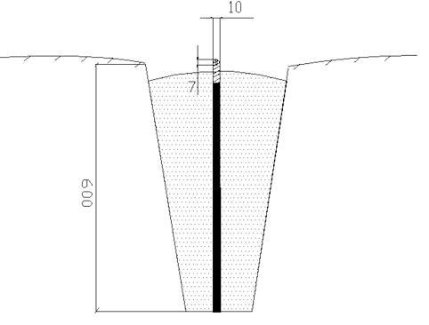 Figure
2 – Structural diagram of site point
Figure
2 – Structural diagram of site point
Between all points distances will be measured by tellurometer, which will secure inaccuracy of measurements 2-5 mm under ordinary weather conditions. Geometrical leveling of the 03rd class is performed in order to find corrections across the slope of line between the points.
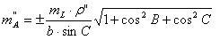
During such measurements each side of site will be known with fractional error not less than 1:2000. Error of each angle may be defined according to the following formula:
Wherein  - error of side measurement;
А,В,С–angles in triangles, indicated clockwise;
b– side length opposite to angle B (numeration of sides in triangle is indicated by letters a, b, c according to the ordinary rule of angle contrast);
 = 206265".
According to the preliminary calculations average square errors on site will not exceed 5 seconds.
In view of the foregoing it is possible to make conclusion that created site on its accuracy and structure will correspond with all due requirements.
Conclusion
At this moment my Master’s Thesis hasn’t been completed yet. The results may be known after defence of Thesis at Mine Surveying Chair in January, 2012.