
Justification of Topic and Title, Relevance of Work
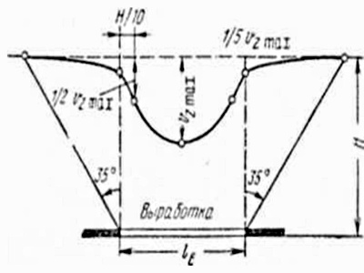
The earth surface deformation due to the effects of an underground mining can cause considerable damage to buildings, structures, caught in the zone of influence of mining. In this regard, mining of coal seams under the surface objects to be protected from the effects of mining, is manufactured according to special projects of undermining of these objects. Projects include subsidence and ground deformation forecast caused by underground mining operations, evaluation of their impact on objects and recommendations on measures to protect the objects. The current method of calculating the deformations of the earth surface provides the use of constant values of the average mining depth in the calculation. This means that the calculation of the deformations is performed for some horizontal plane, which is situated at a distance equal to an average depth of the development from the center of stopping face. Since the real earth surface differs from the deformations calculation plane, there are errors in determining the deformations. Thus, the maximum errors observed for the surface with the major forms of relief, i.e, for mesorelief. Mesorelief is typical for the most areas in the Central Donbass and the Eastern Donbass, where the ratio of mesorelief heights amplitude to the average mining depth reaches 10 — 15% within the allotment of mines. This greatly affects the accuracy of the forecast sediment and horizontal shifts of the earth surface as well as its slope, curvature and horizontal deformations. Therefore, the study of the effect on prognosis of the earth surface mesorelief shifts and deformations due to the underground second working is relevant and important scientific and technical challenge. Relationship with academic programs, plans, execution of work at the request of the institution or industrial organization.
Work is performed in accordance with the direction of long-term research Surveying department as well as in the connection with the scientific institute plans UkrNII. NAS.
The purpose of this paperis to improve the prognosis procedure of the earth surface shifts and deformations due to the effects of an underground stoped excavation, with the mesorelief taken into account.
— Analysis of existing methods of predicting the earth surface shifts and deformations due to the effects of an underground stoped excavation;
— Analysis of software for the calculation of the earth surface shifts and deformations;
— Analysis of techniques to create digital terrain models;
— Development of methods for studying the influence of mesorelief on the accuracy of prognosis and deformations of the earth surface;
— Development of a set of digital terrain models covering the main range of the boundary deformation calculation conditions;
— Development of computer technology of forming a digital terrain model according to the plans of the surface;
— Development of software for the interpolation of height values of the calculated points on the digital terrain model and plotting the earth surface deformation and errors of these deformations due to the effects of mesorelief;
— Comparative analysis of the results for calculations of deformations of the earth surface, taking into account the mesorelief with the results of calculations performed by the current method.
Idea of the paper consists in using a digital terrain model and a dynamic depth development for taking to the account the influence of mesorelief on the accuracy of prognosis of the earth surface shifts and deformations.
The object of research is the method of the earth surface shifts and deformations prediction due to the effects of an underground stoped excavation. The subject of this study is the influence of mesorelief on the parameters of shifts and deformations of the earth surface (precipitation, slopes, curvature, horizontal shifts and deformations) at the trough shift points.
Possible results which are expected in the performance, their novelty and significance. The technique of the shifts and ground deformations forecast due to the influence of the underground stoped excavation with the mesorelief taken into account will be improved.
The reliability and accuracy of this forecast will be increased. The developed software will be used while the development of buildings and structures undermining projects caused by the underground mining.
The analysis of existing methods of shifts and ground deformations calculations while underground coal mining was made in the first chapter.
As a result, it was determined that the most common method for the conditions of Donbass is the method of standard curves [2], which runs on a standard procedure [1]. The advantage of this technique is that the calculations are performed using standard distribution functions of shifts and deformations, established by the analysis of numerous experimental observations of the earth surface shifts in coal mines.
Based on the analysis of observations the following conclusions can be made:
1. Graphs of ground deformation at great depths of development are more uneven than at average depths.
The unevenness is observed mainly at the plots of the curvature at average depths. It applies to graphics of slopes and horizontal deformations at large depths . However, with the quantitative aspect the inequality in the distribution of deformations in deep development has no real significance, since the absolute value of deformations are very small and can be restricted by only the definition of their maximum values.
2. In the calculation of the earth surface shifts and deformation due to mining at great depths (H> 600 m) we must distinguish two possible cases:
a) position of mine workings in seams in space and time are known or specified by schedules of seams mining;
b) schedules of mining strata are absent and there is no data on the size of developments.
We plan to construct a large number of charts and digital terrain models, which provide different amounts of solutions according to the earth surface shifts and deformations. To automate the process by this method there will be developed the algorithm and program for the calculation of the earth surface shifts and deformations, as well as the construction of these conditions. The program is developed in Visual Basic language. After developing a program the results are to be checked on other models, which are used to calculate standard curves, and the analysis of each case is to be made.
We also need to determine the effect of uneven mesorelief on the calculation of the earth surface shifts and deformations, and compare the results of existing method of calculation and one obtained with mesorelief taken into account, not the average depth.
For taking into account the mesorelief influence there was developed an algorithm for calculating the earth surface deformations, based on two new factors. Firstly, it is the use of digital elevation model (DEM) to describe its relief. The mandatory condition for the formation of DEM for undermining the territory is the availability of DEM elevation marks.
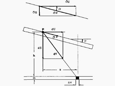
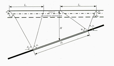
Secondly, in the calculation of the deformation the notion of dynamic depth development is implemented. For each of the i-calculation point, this depth is assumed to be equal to
where Zi — is a mark of i-calculation point; Zc — is a mark of the center of the lava (on the soil layer); H — is a depth development in the heart of lava ; H1 — is the excess of the i-point above the plane of the calculation is separated from the center of the lava to a height H.
Value H1 is determined from the expression
Further the identification of all the calculated parameters and the values of deformations is based on the dynamic depth of development Hd for each of the i-calculation point instead of the average mining depth H.
At the moment work is in the master stage of development. After December 2011. Full text of the paper available from the author or supervisor.