1.1.Overview of research on the topic in DonNTU
1.2 Summary of research on the topic in Ukraine
1.3 Review of research on the global (world)
Relevance master's work
Is typical for most areas in the Central Donbass and the Eastern Donbass, who got into a zone of influence of underground mining. In most cases, the greatest damage to buildings, facilities and utilities are observed on the slopes of the mesorelief. Therefore, the study of the influence of slopes mezorelief prognosis of displacement and deformation of the Earth surface from underground mining are urgent and important scientific and technical challenge.
The purpose and tasks of the master`s work
The purpose of the work to improve methods of prediction of displacement and ground deformation on impact breakage of underground excavation in view of the slopes of the mesorelief.
Research tasks:
1. Analysis of existing prediction methods of displacement and ground deformation on the influence of underground mining treatment and seizures.
2. Analysis software calculation of displacement and ground deformation.
3. Analysis methods for solving problems of digital terrain models.
4. Development of methods for studying the influence of mesorelief slopes on the accuracy of displacement and ground deformation.
5. Develop a set of digital terrain models and objects (buildings, utilities).
6. Development of the definition of the angle of incidence mezorelief in a random direction on the digital terrain model.
7. Development of charting the earth surface deformation on the slopes of the mesorelief.
8. A comparative analysis of the results of calculations of deformations of the earth's surface, taking into account the slopes mezorelief with the results of calculations performed by the existing methodology.
The idea of
Idea consists in using a mathematical model of the joint displacement of the soil layer and bedrock, in which the internal energy in the soil layer initiated the process of settling the Earth's surface from the influence of underground mining.
Relationship with academic programs
Work is performed according to the direction of longterm research Donetsk National Technical University Department of Surveying, as well as in connection with the scientific institute plans UkrNII NAS.
Possible results which are expected during performance, their novelty and significance
Will advances in methodology prediction of displacement and ground deformation on impact breakage of underground excavation in view of the slopes of the mesorelief, increased reliability and accuracy of this forecast. The developed software will be used when drafting undermining buildings and structures underground mining.
Scheduled testing results (participation in conferences, filing papers to contest the publication, filing for an invention, etc.)
Report on the scientific and technical conferences; flow to the contest. Planned publication of articles in peerreviewed scientific volume.
Institute of Mining and Geology, Donetsk National Technical University is one of the leading scientific organizations, which deals with geomechanical models of displacement across the thickness of rock above the cleansing formulation, the processes occurring in the array as a result of underground mining.
Teachers of the department Surveying participate in the development of normative documents.
At the Department of Surveying in studying prediction of displacement and ground deformation on the slopes of the mesorelief from the effects of underground mining are engaged in Ph.D., prof. Grischenkov NN.
On the territory of Ukraine research processes subsidence and ground deformation occurring in the interior of the array as a result of underground mining deals Department of Surveying Dnipropetrovsk National Mining University.
Issues of displacement and ground deformation involved many scientists from the Russian Federation.
- Saint-Petersburg State Mining Institute named after GV Plekhanov;
- South-Russian State Technical University (Novocherkassk Polytechnic Institute).
In the first part of the review of existing methods of calculation of displacement and ground deformation on the influence of underground mining. After analyzing the existing methods, we can conclude that the empirical methods have several advantages over methods based on the functions of influence or theoretical models, since they are based on data from direct field measurements, rather than on abstract concepts of the mechanical model of rock mass and mathematical assumptions.
The greatest propagation and progress in our country was received with a method of typical curves which is carried out on a normative procedure [1].The greatest propagation and progress in our country was received with a method of typical curves which is carried out on a normative procedure [1]. Dignity of this procedure is that calculations are carried out with use of typical functions of distribution subsidence and deformation established as a result of the analysis of numerous experimental supervision for earth surface subsidence on collieries.
At present method of calculation of ground deformation sufficiently defined in the normative document [1], as well as instructions that Ukrainian Research Institute, dedicated to this issue. For the implementation of computer calculations of deformations of the earth's surface has developed a number of software tools to institute UkrNII and DonNTU (DEFO, MULDA, Podrabotka).
In his master work, I'll use the "Podrabotka", which allows the calculation of expected of displacement and ground deformation to any destination on the grid and for the individual points of the basin subsidence.
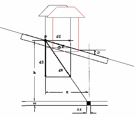
Many studies have noted that the measured displacement of the surface, especially the horizontal displacement, in hilly areas with steep slopes areas, differ from those obtained on flat or moderately hilly surface.
There is a hypothesis that differential subsidence is a joint result of subsidence of the soil layer and bedrock, and the internal strain in the soil layer initiated the process of settling of the earth's surface. On this hypothesis based mathematical model to predict by the method of influence functions of displacement and ground deformation on the terrain with steep slopes [2]. Consider the application of this mathematical model for the prediction of displacement earth's surface over a rectangular cleansing formulation.
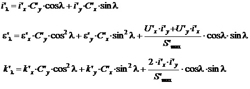
Influence functions for subsidence and horizontal displacement along the slope surface are:
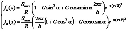
Displacement and strain in the main sections
The values of the slope, curvature and horizontal strain on the slope mezorelief anywhere in the main section of the basin can be obtained respectively as:
To determine the partial derivatives we use the method of statistical modeling.
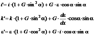
Displacement and strain in any direction
Slope, the relative deformation, the ultimate curvature of the slope surface in a given direction are calculated by the formula:
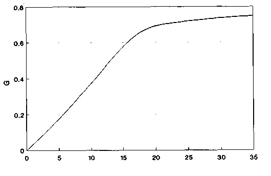
The only additional parameter introduced in the forecasting model of displacement and ground deformation in the hilly regions, is a constant of proportionality G . It is assumed that this coefficient is a function of the angle of repose, the mechanical properties and the power of soil, vegetation on the surface, etc. To determine the coefficient G in [3], a figure based on empirical data (Fig. 2.2).
The main task in the master's work is the creation of software tools for determining the angle of the mesorelief in a random direction on the digital terrain model, and for charting the earth surface deformation on the slopes of the mesorelief. The program is developed in the language of Visual Basic.
In the master's work presents the actual scientific and practical challenge of developing methods for the calculation of displacement and ground deformation on the slopes of the mesorelief from the effects of underground mining.
In the existing prediction technique of displacement and ground deformation from the influence of underground mining is carried out the calculation of the strain at a fixed average depth of development, ie for some averaged horizontal plane. Influence of mesorelief area at the same time is not counted.
On the basis of the hypothesis about the relationship displacement of topsoil and the bedrock of the process due to the earth surface subsidence developed a mathematical model for predicting of displacement and ground deformation on the terrain with steep slopes, ie on the slopes of the mesorelief.
Set of influence functions for subsidence and horizontal displacement along the slope surface. We propose an algorithm of displacement and strain on the slope mezorelief in the main sections of the basin subsidence, and in any direction.
In the future you need to implement all the necessary programs in the environment of Visual Basic.
Important Note
When writing this author's abstract work is not completed yet. Final Completion: December 2011 Full text of the work and materials on the subject can be obtained from the author or a director after that date.
1. ГСТУ 101.00159226.001 – 2003. Правила підробки будівель, споруд і природних об’єктів при видобуванні вугілля підземним способом. На зміну «Правил охраны…» (М.: Недра, 1981. – 288 с.); Введ. 01.01.2004.– К., 2004. – 128 с.
2. Peng, S.S. Surface Subsidence Engineering [Text] / Society for Mining, Metallurgy, and Exploration, Inc. – Ann Arbor: MI, 1992. – 161 p.
3. Knothe, S. Observations of Surface Movements Under Influence of Mining and Their Theoretical Interpretation [Text] / S. Knothe// Proceedings European Congress Ground Movement. – Leeds, UK, 1957. – P. 210-218.
4. Кратч, Г. Сдвижение горных пород и защита подрабатываемых сооружений [Текст] / Г. Кратч; Пер. с нем./ под ред. Р.А. Муллера и И.А. Петухова. – М.: Недра, 1978. – 494 с.
5. Медянцев А.Н., Борщ-Компониец В.И Сдвижение горных пород и земной поверхности при подземных разработках – М.: Недра, 1982, 278 c.
6. Побединский Г.Г. Программирование геодезических задач на языке бейсик.- М.: Недра, 1991, 96 c.
7. Оглоблин Д.Н., Герасименко Г.И., Акимов А.Г. и др. Маркшейдерское дело: Учебник для вузов – 3-е изд., перераб. и доп. М., «Недра», 1981. 704 с.
8. Авершин С.Г. Расчет сдвижений горных пород. - М.: Металлургиздат, 1950. - 60 с.
9. Гавриленко Ю.Н., ПапазовН.М., Морозова Т.В. Динамика оседаний земной поверхности при большой глубине разработки и высокой скорости подвигания забоя.
10. Борщ-Компониец В.И., Батугина И.М., Варлашкин В.М. Сдвижение горных пород и земной поверхности при подземных разработках. - М.: Недра, 1984. - 247 с.