The abstract on the theme of graduate qualification work
Plan
Purpose, idea and research problems
Analysis of carrying out land reforms
Projects of land management CNOEL
Technique of designing of land management CNOEL
Relevance
Cardinal changes of ground relations which have developed during land reform realization in our country, have defined new character and the maintenance of social and economic problems of land-uses: formation of the new landed property, its division and increase, cession of rights, on the ground areas (shares) to land users, transfer of the lands to rent, protection of the lands and rational land use. Constantly appear new land-uses or existent land-uses are arrange. There was a necessity of the maximum satisfaction of economic interests of land owners and the land users, the fullest and an effective utilization of industrial potential of economy and vest lands property in them, at severe observance of especial modes and conditions of use the ground resources [1]. That is why , the main task of land management is to create new and accomplishments of existing landed properties (land-uses) (further projects of land management CNOEL).
Recently considerable attention scientists land surveyor in their works pay much attention to the optimization of land tenure, in particular the agricultural; to definition of optimum parities of ground grounds. In working out of the scientific problems devoted to optimization of land tenure, native and foreign scientists have brought a powerful operating time: I.K. Bistryakov, I.K. Bystryakov, P.P. Borshhevs'ky, M.S.Bogira, S.M. Volkov, V.G. V’jun, P.I. Gajduc'kyj, V.V. Gorlachuk, A.S. Danylenko, B.M. Danylyshyn, D.S. Dobryak, M.I. Dolishnyi, S.I. Doroguncov, A.G.Martyn, V.Ja. Mesel'-Veseljak, O.Ja. Mykula, L.Ja.Novakovs'kyj, P.P. Rusnak, P.T. Sabluk, I.M. Synjakevych, Ju.I. Stadnyc'kyj, A.Ja. Sohnych, M.G.Stupen', A.G.Tyhonov, V.M. Tregobchuk, A.M. Tretjak, Ju.Ju. Tunycja, M.A. Hvesyk and many others [2].
In Ukraine at present the technique of working out of projects of land management CNOEL isn't settled enough by law. Therefore there is a necessity to improve of technologies of creation to such projects, on the basis of the analysis of the techniques applied in foreign countries, entering of offers and introduction of new technologies. These actions will allow to raise efficiency of use of ground resources in agrarian sector, will provide the best organizational territorial conditions and an effective utilization of ground grounds.
The purpose, idea and research problems
Purpose of the work: To develop technological model for working out of projects of land management CNOEL.
Idea of work: Reception of modern technology of working out projects of land management CNOEL.
Research problems:
1) Revealing of advantages and advantages of an existing technique of working out for the purpose of improvement of projects of land management CNAEI.
2) The Analysis of the international experience from working out of projects of land management CNOEL, for the purpose of possible their adapted in Ukraine.
3) Reception of model and algorithms for working out of projects of land management CNOEL.
An object and subjkt of research: : The Project of land management CNOEL.
Scientific novelty of research: Revealing of advantages and advantages of an existing technique of working out for the purpose of improvement projects of land management CNOEL. Others will be allocated in the course of a writing master work.
Practical value of work: Application of a technique working out projects of land management CNOEL in Ukraine:
1) will allow to raise efficiency of use of ground resources in agrarian sector;
2) will provide the best organizational territorial conditions and an effective utilization of ground grounds;
3) offers concerning working out projects of land management CNOEL can be used for the subsequent researches.
Approbation of results: Participation in scientific conferences DonNTU representation on competition of fund of Pinchuk, the work publication on the site of masters DonNTU, and in the thematic collection.
The analysis of carrying out the land reforms
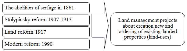
During the existence of Ukraine has endured 4 land reforms. Two first reform (the first reform - the abolition of serfage in 1861, the second – were carried out, when Ukraine was a part of Russian empire, the third reform (in 1917) - when was a component of the former USSR, the fourth - modern, is carried out in the conditions of reception by it to the status of the sovereign state. All these reforms have led to creation of projects of land management concerning creation new and accomplishments of existing landed properties (land-uses) (fig. 1) [3].
Any changes, conected with creation new or an accomplishment of existing landed properties and agricultural land-uses enterprises, carry out on the basis of projects of territorial land management.
The value of such projects has especially grown in land reform after 1991 when reorganization was tested by almost all agricultural enterprises of Ukraine.
In general for Ukraine for 1991 —2005 was characteristic increase in quantity of land owners and land users which are engaged in agricultural production, and also reductions of the areas of the ground areas which are in state ownership [6].
Projects of land management CNOEL
According to article 51 of the Law of Ukraine «About land management» it is certain that projects of land management CNOEL are developed for the purpose of a substantiation of the sizes and limits of the ground areas taking into account requirements concerning rational use and protection of the earths.
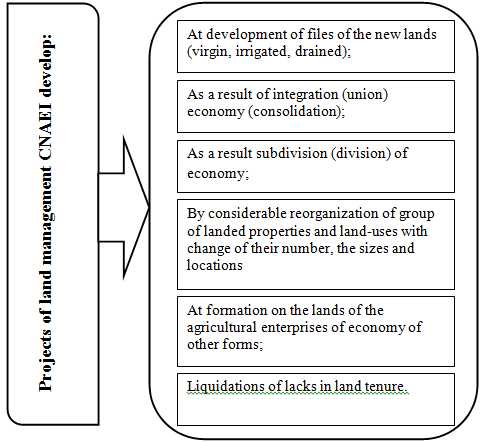
Designing of land management CNOEL is carried out for the purpose of formation of territorial conditions for development of different forms of housekeeping on the earths, formation of rational and proof system of landed properties and землепользований, consolidations of the ground areas of ground shares, improvements of use and protection of the earths (fig. 2) [5].
At designing of land management CNOELit is necessary to be guided by such main principles and requirements [6]as:
- creation of identical conditions for development of all forms of landed property and land tenure and housekeeping on different in quality and a place of placing the earths;
- voluntary will of owners of ground shares (shares) concerning them united in new industrial structures and the order the parts on the terms of defined by the land management project;
- accommodate the interest of all land owners and land users which are mentioned;
- the maximum preservation of elements of the organization of territory which have developed in the existing agricultural enterprises;
- creation of organizational territorial conditions which provide economic land tenure rationalization, steady growth of fertility of soils, preservations and improvements of environment and landscapes;
- limits of ground files of again created landed properties and землепользований should be established taking into account investment appeal of types of land tenure, their compact placing, stability of landscapes;
- allocation of the irrigated earths should be carried out by fields of crop rotations or files, or the areas, multiple seasonal productivity irrigation machine and installations, and to provide an effective utilization of the earths and the sprinkling equipment in a design mode;
- allocation of the drained earths is carried out on conditions which provide preservation of a drying network in a design mode;
- nonagricultural grounds are transferred to the possession taking into account placing of the ground areas which are allocated on account of the ground shares (shares) existing and again created agrostructures, directions of their activity and requirements of rational use and protection of the earths.
Designing of land management CNOEL is spent on the basis of a special delicacy and careful inspection of the ground files given for placing объъектив of land management, thus are guided by the basic indicators (fig. 3 see) [6].
In case of performance of these requirements it is created constant land-use which answers to the conditions of normal development of an economy, ordered use and land protection, in it, and also gives the chance to consider interests of development of agriculture in this territory.
Creations of landed properties and land-uses for agricultural purpose the enterprises — where land surveying actions which provide drawing up, consideration, the statement of the project and its transferring, to nature in which result the new ground areas are created and are made out on them правоуставные documents [6].
A technique of designing of land management CNOEL
1. The Spadework.
2. Estimation of a condition of use of the lands.
3. Identification of the property rights and land rent.
4. A substantiation of the previous design decisions.
5. The organization of territory of agricultural landed properties and land-uses on the different right.
6. Formation of restrictions in use of the earths and ground easement.
7. Economic estimation of efficiency of design decisions of an accomplishment of existing landed properties and land-uses and creations of the new.
8. Consideration and the project statement.
9. Manufacturing and delivery of the design documentation.
Ordering of the land concerning elimination of lacks of landed property and land tenure consists of a spadework, drawing up of the project, considerations, statements and project transferrings, to nature, official registration of papers.
Elimination of lacks consists not in liquidation of the site (interspersed or enclavement of plots), and in the termination or mitigation their negative influence on the manufacture and territory organization.
The basic ways of liquidation of lacks of landed property and land-uses:
- an exchange of equal and equivalent grounds between economies;
- an exchange of not equal and not equivalent sites (with monetary indemnification);
- free transfer of the lands from one economy to another;
- transfer of the earths of one economy to another without an exchange land sites with monetary indemnification (the repayment or selling the ground area);
- full reorganization of landed properties and землепользований.
These ways not always give the chance completely solve the final task of perfection of landed properties and the land user, them it is possible to supplement with methods intraeconomic land management (transformation of grounds, introductions of crop rotations of different intensity, moving of the economic centers, change land regulation specializations, and others) [6].
Applications of GIS-TECHNOLOGIES
The Project of land management CNOEL consist on good-quality according to plan-kartografichnoj to a basis with use of materials soil, geobotanical, agricultural, meliorative and other inspections, quality standard of the earths, and also materials, before the spent land management [7].
GIS provides working out and the analysis of a significant amount of variants of design decisions, creations of recommendatory and administrative cards, on regions that gives the chance to find most optimum ekologo-economic justification of system of actions for the organization of territory and protection of the earths of again created agrostructures, their formation, constant land tenure, a reconstruction natural agricultural landscape, operative control of use of ground resources, forecasting possible erosive processes, creation of erosion preventive the territory organizations. Accumulation of the information on the degraded and unproductive lands provides an operative substantiation of their conservation [8].
Application of methods GIS will allow to analyze in an automatic mode a current condition documented land tenure, to find out earlier припущени lacks and errors, and also in a tabular kind in a few minutes to form files of data on the ground areas and the rights to them certain land users.
Consequently, application of GIS-TECHNOLOGIES considerably will facilitate procedure of designing of land management CNOEL.
Conclusions
In given master work it is solved a scientifically-practical problem which consisted in revealing of advantages and lacks of an existing technique of working out for the purpose of improvement of projects of land management CNOEL
Improvement of a technique, working out of offers, and introduction of new technologies concerning drawing up of such projects of land management CNOELwill allow to raise efficiency of use of ground resources at the expense of the organization of rational landed property and land-uses in agrarian sector, will provide the best organizational territorial conditions, an effective utilization and protection of ground grounds, creations of the favorable ecological environment, and improvement природних landscapes.
During a writing of the given abstract master work hasn't finished yet. Definitive end - December in 2011 the Full text of work and materials on the theme can be received at the author or its head after noted date.
List of the used literature
1. Романова В.А. Автореферат диссертації. Соціально-економічна ефективність використання земельних ресурсів регіону 2005 год. [Электроний ресурс].— Ресурс доступа: http://disser.com.ua/contents/p-2/37929.html
2. Колганова І. Стан та проблеми інноваційного розвитку землеустрою у період проведення земельної реформи в Україні. [Электроний ресурс].— Ресурс доступа: http://www.nbuv.gov.ua/Portal/Chem_Biol/Vldau/APK/2010_2/files%5C10kilriu.pdf
3. Лекції «Основи землевпорядкування та кадастру». Лекція 4 - Концептуальні основи земельної реформи і проблеми її проведення. 23.10.2008р.
4. Закону України «Про землеустрій»від 22.05.2003с № 858-IV [Электроний ресурс].— Ресурс доступа: http://zakon1.rada.gov.ua/cgi-bin/laws/main.cgi?nreg=858-15&p=1299674901619331
5. Веселовська Л.Ф. Землевпорядкування: Підручник. М.: ЮРКНІГА, 2004. — 256с.
6. Третяк A.M. Землевпорядне проектування: Теоретичні основи і територіальний землеустрій: Навч. посібник. — К: Вища освіта. 2006. — 528 с.
7. Ткачук Л.В. Консолидация земель: Эффективное использование и охрана в условиях трансформации земельных отношений: монография/ Л В. Ткачук — Львов. Львовский национальный аграрный университет, 2009. — 249 с.
8. Застосування ГІС-технології у сфері земельного кадастру та землеустрою [Электроний ресурс]. — Ресурс доступа: http://www.zisforum.org.ua/index.php?topic=242.0.