Abstract
Content
- Introduction
- 1. Actuality of theme
- 2. Aim and research tasks
- 3. The main parameters of waste dumps
- 4. Existing packages for the construction of 3D-models
- 5. Current research results
- Conclusions
- List of sources
Introduction
In Ukraine, as a result of the 500 industrial solid waste accumulated only about 25 billion tons. These wastes have a negative impact on the natural landscape and environmental conditions, occupying an area of about 150 thousand hectares of fertile land and degrading the habitat of man. Man-made deposits lead to exclusion from economic turn large areas of land occupied by industrial waste.
Over 200 years of commercial production of coal in the Donbass and their accumulated an enormous amount of processing waste: for every inhabitant of this region accounts for about 4,000 tons of dumps.
Waste dump – man-made array, formed on a designated area of the rocks obtained during the development of the field [1].
Waste dumps are the following forms: conical, hrebtovidnye, flat, combined.
Tapered blade breed – a blade of some kind of rocks or materials formed by pouring a specific surface of loosened soil. This blade has the shape of an irregular cone.
Tapered piles maintained to a height of 100 meters and should be further reformed in the flat.
Hrebtovidny blade formed a consistent formation of a conical pile.
Combined form – the formation of combinations of conical and flat dumps.
Flat blade – is a form of storage of rock, in which the platform is formed on its surface.
The flat shape of the blade – is the main form at this time [2].
1. Actuality of theme
From 1257 heaps and heaps of coal mines to 35% subject to the processes of spontaneous combustion of coal. Liberated at the same time of the centers of the hot gases of combustion are deposited on the surface of native sulfur, ammonia, and other man-made minerals. Within a radius of 3 km each slagheap is a source of pollution of air, water and surface environment by various toxins, including arsenic, mercury, etc.
On the other hand, if used properly, waste heaps can be useful.
For example, from 1 ton of waste dumps are available: 55 g germanium, which is used in electronics and optics, 20 g scandium – the production of aviation equipment, laser materials, etc., 100 g gallium, which can be used in the manufacture of lubricants, as well as elements for solar cells [3].
Hence the need to calculate the parameters for the classification of waste dumps and further reorganization.
2. Aim and research tasks
The aim of this work is to develop a computer software system for calculating the parameters and modeling of waste dumps.
To achieve the goal it is necessary to solve the following tasks:
- Define the basic parameters for the classification of waste dump and further reorganization;
- Review existing methods and tools for building models, heaps, their advantages and disadvantages;
- Construct a model of waste dumps and determine the resulting accuracy;
- To develop software to perform assigned tasks.
3. The main parameters of waste dumps
The main parameters of waste dumps are shown in Table 1.
Table 1 – Main parameters of waste dumps
Studies DonNTU found that the area of the lateral surface of waste dump conical shape is an indicator of its degree of environmental risk and is determined by the formula (1):

where H – height of the waste dump [4].
It should be made in the passport of each waste dump is also an indicator such as its surface area and monitor its changes over time. In forming a conical blade at the time dependence of the surface area of the height described by (2):

where H – height of the waste dump [5].
4. Existing packages for the construction of 3D-models
To date, there are software tools that allow to construct three-dimensional model of waste dumps. To those include software OziExplorer, Complex 3D analysis, ArcGis 3D Analyst.
In our computer system for modeling rock dumps used by the software OziExplorer3D.
To create three-dimensional model of the image must be OziExplorer3D waste heaps, file binding to grid coordinates and the corresponding values of the heights of points on the earth surface.
As a high-altitude data were selected files SRTM.
Construction of three-dimensional model is presented or waste dump in Figure 1.

Figure 1 – Construction of three-dimensional model of waste dump
(animation: 9 frames, 6 cycles of repeating, 138 kilobytes)
5. Current research results
To determine the accuracy of SRTM source data and the construction of three-dimensional models in the software product OziExplorer3D [9] constructed a model 12 heaps of mines in Donetsk region.
Images of rock dumps were obtained using SASPlanet [7].
This software provides the ability to find the desired object on the maps Google, GoogleEarth, Yahoo!, Navitel, Wikimapia, Gurtam, Yandex.
You also have the ability to view individual layers of the earth's surface.
Used for the investigations cards Google.
For waste dumps were used to image scale of 0.4 m/pixel to 0.8 m/pixel, which corresponds to a height of 25 m and 50 m shooting above the earth's surface.
Each image corresponds to the mapping file with the extension .map. It stores the coordinates of the selected section of the earth's surface.
SRTM data for selected waste heaps are four files: N47E037.hgt, N47E038.hgt, N48E037.hgt and N48E038.hgt.
The letters N and E in the file name denote the northern and eastern hemispheres, 47 or 48 – latitude, 37 or 38 – of longitude coordinate of the upper left corner of the square surface, represented in the file.
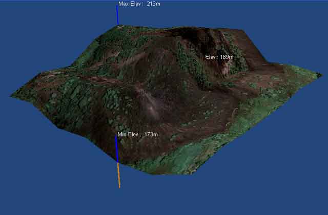
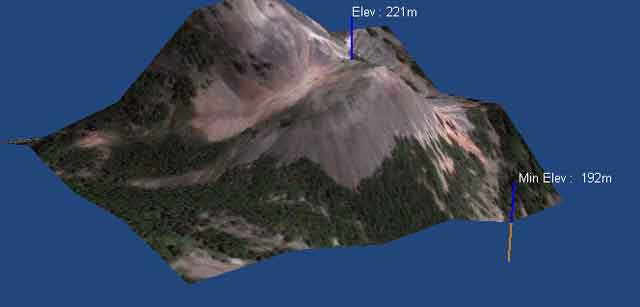
Opening a file in OziExplorer relation to the coordinates and connecting the desired altitude, you can build a model of waste heaps (Figure 2, Figure 3).

Figure 2 – 3D model of the waste number 2 of the mine "Mospino"

Figure 3 – 3D model of the waste number 2 of the mine "Chervonogvardeyskaya"
Obtained in the simulation data were compared with accurate geodetic measurements [4] .
Results and errors are also presented in Table 2.
Table 2 – Waste dumps, which were built three-dimensional model
As shown in Table. 2, the error in the simulation package OziExplorer is large enough. In addition, the software is not focused on the construction of waste dumps and has no tools to calculate the main parameters.
Thus, there arises the need for specialized software to calculate parameters and modeling of waste dumps.
Conclusions
A computer system for calculating the parameters and modeling of waste dumps c using standard packages.
Machine performed experiments on three-dimensional models using satellite imagery waste dumps 12 mines in Donetsk region.
Determined by the relative error in the height of heaps of data models.
The results showed that to increase the accuracy of the construction and dimensioning waste dump, as well as determine the degree of environmental risk is necessary to develop specialized software.
The simulation results allow to make a decision about the possibility of reorganizing waste dump: an increase in the degree of landscaping, changing the shape of waste heaps to reduce gas and dust.
By the degree of environmental hazard waste dump can be concluded about the possible construction near the waste heaps, the extraction of rare substances in a heap, the use of burnt rocks as a balancing layer for road construction and even the construction of small wind farm on the heaps.
When writing the abstract of the master's work is not yet complete.
Final completion: December 1, 2012
The full text of the work and materials on the topic can be obtained from the author or his scientific adviser after that date.
Parshutina А. А.
