
Abstract
Content
- Introduction
- 1. Terrestrial stereophotogrammetric survey
- 1.1 Terrestrial digital architectural stereophotogrammetric survey
- 1.2 Analysis of the literature
- 1.3 Creation of a software product "Create the interactive project survey»
- Conclusions
- Referenses
Introduction
Subject: Method for increasing the accuracy of architectural terrestrial digital stereophotogrammetric survey
Topicality: Digital devices based on the use of CCDs, combined with computer technology, can cardinally change the number of technologies geodesy and photogrammetry survey. This contributes to widespread consumer-grade digital cameras with non-metric rather large information capacity at relatively low cost.
Photogrammetric methods have always been more productive and cost-effective than traditional methods. With the development of digital technology in the methods of the difference is even larger. Not only simplifies the process of shooting, and post-processing that is performed on the digital photogrammetric stations. The need for architectural photography can occur when facing facade of the building, its renovation, restoration, study, architectural elements, the documentation states at a given time. Shooting a purely geodetic methods is very time consuming and is associated with the difficulties of direct access to the object. Modern digital technology allows the facade to shoot and process images as soon as possible and much safer for the performers.
Relevant is the issue of increasing the accuracy of survey.
Communication with scientific programs: Master's work meets the scientific direction of the department.
Purpose and objectives of the study: The purpose of master's work is to investigate the accuracy of terrestrial digital stereophotogrammetric architectural survey, using the coordinates of points of photography.
To achieve this goal the following tasks:
– develop a program for designing various types of triangulation networks;
– study of the accuracy of the designed network triangulation with the coordinates of the centers of photographing and without them.
Object of study: The accuracy of terrestrial digital stereophotogrammetric architectural survey.
Subject of study: Triangulation network designed in the developed program.
Research Methods: We used the methods of mathematical modeling, programming, analytic geometry, probability theory and mathematical statistics.
1. Terrestrial stereophotogrammetric survey
1.1 Terrestrial digital architectural stereophotogrammetric survey
Architecture – a historic part of our cultural heritage. Architectural daily weather conditions for yield: the wind, rain, snow, temperature extremes. Therefore, it is important to constantly monitor their condition and injuries. The main way to save the monuments are being reconstructed. But for these works must have front and interior plans of buildings, and these plans should be created at the time of restoration. It is not always geodetic methods it can be done quickly, and sometimes impossible.
The main advantage of photogrammetric methods lies in the fact that at any given time you can get the spatial coordinates of the points of the object, that is an idea of ??its shape and size. Of particular value, these methods become in those cases where you want to measure a large number of points, and the object is in motion, change, or difficult to reach. Therefore, for the creation of architectural plans, one of the best methods will be the ground-based digital photogrammetric survey. Many scientists are also developing methods to improve accuracy by combining the results of ground stereophotogrammetric sutvey and laser scanning.
Modern advances in computer technology, as well as theoretical studies in the field of image processing have made possible the use of digital techniques. Formed digital photogrammetry, where photogrammetric processes are fully automated through the use of digital images obtained by scanning photographs or directly using the number of metric and nonmetric cameras.
Shape, size and position of the object can be determined to photograph it with two points. In the pictures you can get the model object. It's enough to give a snapshot of the situation that they took to each other during the shoot.
The method of measuring the images based on the use of a pair of images, called stereophotogrammetric.
Photogrammetric image processing engineering and architectural objects has fundamental differences from the aerial treatment, conducted on digital photogrammetric stations.
1.2 Analysis of the literature
Idea of using images for measurement purposes, including architecture, arose after Lossed's invention photography in 1838. In 1850, it has been proved for the first time the principle of terrestrial photogrammetric survey. His way of fixing the image on a photographic plate in terms of accuracy has surpassed all methods used in those days. The first photogrammetric survey carried out landmarks in 1858. In 1861, A. Rollet has developed the basic principles of stereophotogrammetry, which laid the foundation for the use of stereoscopy in photography.
On the application of photogrammetry in architecture, fine arts, as well as for protection of historical monuments are regularly held international symposia under the auspices of the International Committee for Architectural Photogrammetry – CIPA, which was established in 1970 in accordance with the decision of the UN.
Fundamental principles ground surveys have been studied from the works of A. Lobanov and S.G. Mogilny. [10, 11]
Need to use the coordinates of the photograph in order to improve the accuracy of aerial photography proved by the authors [1, 8, 15].
In [8] performed experimental studies of various options adjustment of photogrammetric networks on real industrial materials, and evaluation of the accuracy of their capacity to establish a basis of planning and mapping of land-cadastral, topographic and other maps and the plans. Adjustment was performed using different input data. The main conclusion: the equalization using the coordinates of centers of photography gives more accurate results (both in plan and height) than the adjustment only on the control points. Monitoring the results of adjustment can be performed on some coordinates of the centers of the photo, not included in the equation. To determine the number of coordinates and their location in the block, additional experimental studies.
In the article [9] design method to be used me, is called the "trial and error." The main disadvantage of this approach to solving design problems is the need for multiple computing and high demands on the performer. The author proposes to automate the determination of the optimal network. However, no provision to use the coordinates of the centers of photographing.
Since we need to investigate the effect on the accuracy of these coordinates, the program will be developed with a preliminary design scheme of the network. But this measure will contain random errors, which are subject to the normal distribution law.
1.3 Creation of a software product "Create the interactive project survey»
If we had a camera with a field of view large enough to one basis you can take pictures of the whole structure, the question of creating a project there would be no shooting. However, we consider the digital camera Olympus E20p, whose field of view is 14 degrees. That is, the problem arises of determining the number of bases and the number of routes required to capture the building.
To create a project must have taken the original data. The initial data are the elements of interior orientation, exterior orientation, the size of the building, the size of the frame digital camera.
The program also possible to load an object image to create the visibility of the project.
Result of the project will create a file *.del. In which are: geodetic control points, the coordinates of the points of photography, measurements made on the stereo pairs. Measurements will include random error, subject to the normal distribution law. Using the program DonetskFoto, S.G. Mogilny developed, we will be calling different variants of networks with different parameters (with the coordinates of the center photo and without), in order to prove the increase in the accuracy shooting when using the coordinates of points of photography.
The program is developed in a programming environment Delphi.
Picture 1 shows the principle of the program. The program consists of a main form, which is carried out design and an additional form, which introduces the mean square error, to generate random errors. The first stage – the boot image of the object and the input parameters of the camera and the building. Next, we begin a new route, we introduce the elements of exterior orientation parameters and obtain a stereo pair. When the stereo pair satisfies all requirements, we press the button to capture, and data are stored stereo program. Now you can set the control points by clicking in the field of building mouse button. After designing the route we can finish the route and start a new one, or save the file *.del. This file can be saved with the random measurement errors, and without them. After you save a file you can open the program and calling BlockMSG projected network of triangulation. At any given project, you can save and then open for the continuation of the design.
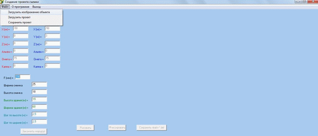
Picture 1 – Creating a project survey
Conclusions
Currently, the software "Create the interractive project survey" testing, possible errors are eliminated, added functions for user convenience.
The mathematical apparatus is understood fully and implemented, so that in the near future I will move on to the next task of the scientific – research the accuracy of the designed networks.
Also planned to study foreign literature, for a development of themes fuller.
Список источников
- Антипов И.Т. Пространственная фототриангуляция с использованием координат центров проектирования //Геодезия и картография. – 2004. – №8. – С. 21-30
- Вайнаускас В.В., Мардосене Д.М., Путримас Р.С. Применение аналитической фотограмметрии для решения инженерных задач. //Геодезия и картография. – 1984. – №10. – С. 26-31
- Гельман Р.Н. Возможности использования обычных цифровых камер для наземной стереосъемки. //Геодезия и картография. – 2000. – №4. – С. 39-41
- Гельман Р.Н., Никитин А.В. О стереофотосъемке фасада здания //Геодезия и картография. – 2008. – №1. – С. 29-33
- Калантаров Е.И., Говоров А.В., Никишин Д.А. Универсальные методы цифровой фотограмметрии. //Известия ВУЗов. Геодезия и аэрофотосъемка. – 2003. – №6. – С. 47-55
- Калантаров Е.И., Никишин Д.А. Развитие процессов фотограмметрии перспективными методами. //Известия ВУЗов. Геодезия и аэрофотосъемка. – 2003. – №1. – С. 95-104
- Катушков В.А., Сердюков В.М. Моделирование макетных снимков для задач наземной фотограмметрии. //Геодезия и картография. – 1999. – С. 22-25
- Кекелидзе В.Б., Мельников А.В., Мышляев В.А., Тювакин Д.В. Использование координат центра фотографирования при обработке материалов аэрофотосъемки //Геодезия и картография. – 2003. – №5. – С. 31-35
- Корчагина О.А. Некоторые вопросы автоматического способа проектирования оптимальных фотограмметрических сетей для съемки инженерных сооружений. //Известия вузов. Геодезия и аэрофотосъемка. – 1990. – №5. – С. 107-110
- Лобанов А.Н. Фотограмметрия: Учебник для вузов. 2-е изд., перераб. И доп. – М., Недра, 1984, 552 с.
- Могильный С.Г., Беликов И.Л., Ахонина Л.И., Брежнев Д.В. Фотограмметрия. – Киев.: Вища школа, 1985, 278 с.
- Уставич Г.А., Пошивайло Я.Г. О применении неметрически цифровых камер для инженерно-геодезических измерений //Геодезия и картография. – 2005. – №8. – С. 19-24
- Чибуничев А.Г. Оптимизация проектирования фотограмметрических съемок инженерных сооружений. //Известия вузов. Геодезия и аэрофотосъемка. – 1990. – №5. – С. 87-95
- Чибуничев А.Г., Корчагина О.А. Алгоритм проектирования оптимальной фотограмметрической съемки инженерных объектов. //Известия вузов. Геодезия и аэрофотосъемка. – 1993. – №3. – С. 93-102
- Ярмоленко А.С., Шошина Е.Ю. Установление точности одномаршрутной пространственной фототриангуляции с использованием координат центров проекции. //Геодезия и картография. – 2007. – №1 – С. 46-51