
Abstract
Содержание
- Introduction
- 1. Theme urgency
- 2. Goal and tasks of the research
- 3. An approach to the unification of synthesis of Moore FSM on FPGA
- Conclusion
- References
Introduction
The
spectrum of geo-ecological problems of big cities and industrial zones
that
require timely solution is quite broad. These problems include: air
pollution
emissions from industrial enterprises and vehicles, pollution of
surface and
ground water due to discharges of pollutants and flush them from urban
areas,
soil pollution, accumulation of industrial and domestic waste and
recycling
[1].
One of the major environmental problems has
been and remains the rational
use and protection of water resources from pollution and depletion.
Surface
water quality in the urban area should be seen as the result of a
complex
combined effect of divergent processes of contamination and самоочищения.Экологическое
status of
water bodies is largely determined by the combined effect of many
man-made
factors. The most significant of them discharge into water systems are
inadequately treated wastewater from municipal and industrial
facilities
through the sewer system of polluted snowmelt and rain water, household
and
industrial landfill sites within the catchment area, emissions from
industry
and road transport, recreation load in the field organized and
unorganized
recreation. The major pollutants of surface waters until recently
considered to
be industrial and municipal effluents.
The control system of the
environment
consists of three main activities: 1) tracking and monitoring - the
systematic
monitoring of the environment, 2) the forecast - the definition of the
nature
of possible changes under the influence of natural and anthropogenic
factors,
and 3) management - event management of the environment [ 2].
Ability
to
monitor the environmental remote sensing have opened,
installed on aircraft and satellites orbiting the Earth. Images of the
Earth's
surface, obtained with different heights, infinitely expanding field of
view of
the researcher. Aerospace methods gave the same powerful impetus to the
development of earth sciences, both at the time the invention of the
microscope
in biology.
The
following
features and advantages of space monitoring:
-
Are
observed and recorded information on a wide area, until all
visible at the time of the shooting of the globe, thanks to the great
visibility of the pictures can be seen particularly large regional
economic
impact on natural landscapes;
-
Give the
same type of satellite imagery and detailed information about
remote areas with the same accuracy as for the well-studied regions,
which
allows using the extrapolation method of interpretive signs on the
basis of
allocation of landscapes, unique;
-
Instantaneous images of large areas to minimize the influence of
variable weather and seasonal factors, the possibility of regular
repeated
surveys allows you to select the best images, based on repeated surveys
studied
the dynamics of natural processes;
-
The
complexity of the information contained in the satellite imagery,
allowing their use for studying the complex processes of interaction
between
society and nature;
-
For
high-resolution images can be recognized especially the
morphological structure of landscapes and man-made structures. However,
due to
the natural generalization of the image, satellite images show the
largest and
most important elements of the geographic envelope, and traces of human
impact.
1. Theme urgency
The problem of environmental protection is one of the most important tasks of science, which increases interest in connection with the pace of technological progress in the world. At this stage of development of civilization can not be avoided emissions of pollutants into the air and water, but in the case of the wise use of natural resources can provide a safe level of exposure to the atmosphere [3]. Currently, water quality monitoring conducted in low volume. Increasing environmental stress in the big cities and industrial areas requires more rigorous and more large-scale observations of the environment. The main factors of anthropogenic pollution of the sea are: runoff, runoff, coastal erosion, oil spills and oil products of different origin. First of all, subject to intensive coastal water pollution. To increase the effectiveness of monitoring of environmental conditions necessary to quickly and efficiently determine the type of contaminants, as well as their genesis and consequences [4]. Space remote sensing tools for monitoring the status of water bodies and allow you to identify the sources of pollutants, to determine the degree of contamination of various parts of the object and the dynamics of contamination over time (Figure 1.1).
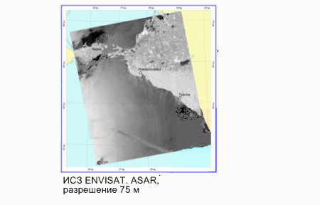
Figure 1.1 – Deshefrirovanie
pollution from
ships on the ENVISAT image radiolakatsionnom
( animation:
10 frames, 5 cycles of repeating, 267 kilobytes)
(ENVISAT-satellite image of the visible range)
Master's
thesis is devoted to actual scientific problem of one of the
existing methods of informativeness of the test pieces, which is based
on a
comparison with the standard method, in which the calculated
cross-correlation
coefficient.
2. Goal and tasks of the research
The
study aims
to develop a method for the study of informativeness of test
pieces, which is based on the method of comparison with the standard.
The
main
objectives of the study:
1. Analysis of existing test
methods informative figures;
2. The development of
artificial
interpretive signs, formed during the processing of satellite images;
3. Path Selection area of
interest;
4. Converting study units;
5. Normalization of the data [5];
6. Determination of
cross-correlation function between the contours of the study and test
figures;
7. Calculation of correlation
coefficients of test pieces for each type of pollution;
8. The formation of tables of
correlation coefficients for all types of pollution for each test
figure;
9. Analysis of the results[6].
Object of study:
satellite images
of contaminated sites watershed.
Subject of research:
the method of
study informativeness of test pieces,
which is based on a comparison with the standard method, in which the
calculated cross-correlation coefficient .
As
part of the
master plan to get the actual scientific results in the
following areas:
1. The development of
artificial
interpretive signs, formed during the processing of satellite images[7];
2. Development of algorithm
selection circuit area of
interest[8];
3. The implementation of the
method of study informativeness of test pieces, based on the method of
comparison with the standard[9].
3. Informative study of test pieces using the method of comparison with the standard
In
processing
the satellite images of the optical range for the tasks of
monitoring is insufficient to use only natural interpretive signs,
which
include spsktralno-brightness features, the shape of the selected spot,
its
structure and dynamics of the changing contours of the spot in time [30].
All
these features are systematized and described verbally [31],
and therefore the
conclusion about the nature of the anomalous spots on the sea surface
is
largely dependent on operator experience, which foresees the processing
of
satellite images. Therefore, to better determine the type of
contamination
based on the space survey is necessary to develop artificial
interpretive
signs, formed during the processing of images.
To
isolate the artificial
interpretive signs used by a natural interpretive features - a form of
isolated
spots on the sea surface anomalous phenomena. In [50] showed that for
each type
of pollution is characterized by some form of spots. In this paper it
is
assumed that the use of this feature will increase the probability of
determining the type of contamination.
The
study
involves the allocation of spots forms the contour area of
interest.
Allocation algorithm is shown
in ris4.3. In the above case, automatic selection of areas in satellite
images
of water surface is achieved by using a linear function of the
separation [4].
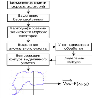
Figure 4.1 - Algorithm selection of the contour plot..
One of the main ways to detect objects in the image is compared with the standard. In this model we are interested in is compared with all unidentified objects in the image. If the similarity between an unknown object and the standard is sufficiently large, then the object is flagged as an appropriate reference object. The complete coincidence of a reference to any part of the picture is rare because of the noise and distortion caused by the spatial discretization and quantization of brightness, as well as due to the lack of a priori information on the exact shape and structure of the object to be detected. Therefore, usually with the help of some specific measures razlichiyamezhdu standard and image of the point indicate the presence of the selected object, where the difference is less than some threshold. Usually taken as a measure of the difference srednekvadreticheskaya error, defined as

where  —
the array images to be searched, and
—
the array images to be searched, and 
 with coordinates, if
Now consider this equation as follows:
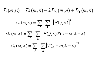
The
term  - is
the energy of the standard, which is constant and independent of the
coordinates. The second term - the cross-correlation image and the
reference. When
a match is a reference image and the cross-correlation must be large,
which
leads to small values of
the mean square error.
- is
the energy of the standard, which is constant and independent of the
coordinates. The second term - the cross-correlation image and the
reference. When
a match is a reference image and the cross-correlation must be large,
which
leads to small values of
the mean square error.
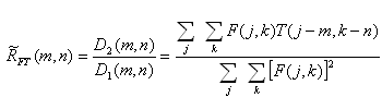
It is believed that the similarity with the reference occurs, unless

Normalized cross-correlation has a maximum value equal to one if and
only if the image in the box exactly the same as the standard [32].
Conclusion
The
resulting
correlation analysis of data showed that application of the
proposed method of feature extraction by cross-correlation contours of
the test
patches and test figures to determine the most informative test figures.
The
results presented here are used for the further development of
automated
identification algorithm types of pollution, which will enable more
effective
satellite monitoring of sea areas of the Black and Azov Seas.
Master's
thesis
is devoted to actual scientific problem of one of the
existing methods of informativeness of the test pieces, which is based
on a
comparison with the standard method, in which the calculated
cross-correlation
coefficient.
In
the trials carried out:
1. Analysis of existing test
methods
informative figures;
2. The development of
artificial
interpretive signs, formed during the processing of satellite images;
3. Path Selection area of
interest;
4.
Converting study units;
5. Normalization of the data[10];
6. Determination of
cross-correlation
function between the contours of the study and test figures;
Further
studies
focused on the following aspects:
1. Calculation of correlation
coefficients
of test pieces for each type of pollution;
2. The formation of tables of
correlation
coefficients for all types of pollution for each test figure[11];
3. Analysis of the results.
In
writing this
essay master's work is not yet complete. Final completion:
December 2012. The full text of the work and materials on the topic can
be
obtained from the author or his head after that date[12].
References
-
Луканин В.Н., Трофименко Ю.В. Промышленно-транспортная экология: Учебник для вузов. - М.: Высшая школа., 2001. - 273 с. -
Проблемы создания региональных геоинформационных комплексов и опыт решения прикладных задач на основе аорокосмичсской информации / отв. ред. В.В. Лебедев. - М.: Наука, 2002. - 239 с. - Марчук Г. И. Математическое моделирование в проблеме окружающей среды – М.: Наука, 1982–315 с.
- Красовский
Г.Я., Петросов В.А. Інформаційні технології космічного моніторингу
водних екосистем
і прогнозу водоспоживання міст. – К.: Наукова думка, 2003.
– 224 с.
-
Математические модели электронных аппаратов и систем / М.Ф. Бабаков, А.В. Попов, М.И. Луханин: Учебн. пособие. - X.: Нац. аэрокосмический ун-т «Харьк. авиа. ин-т», 2003. - 109 с. - Duda
R. О., Hart P. Е., Pattern Classification
and Scene Analysis, Wiley-lnterscience, New York, 1973, pp.
276—284. (Имеется перевод: Дуда P., Xapt П., Распознавание
образов и анализ сцеп. — М.: Мир, I97G.J
Ito M. Algebraic theory of automata and languages / M. Ito. – World Scientific Publishing, 2004. – 199 pp. - Highleyman W. Н., An Analog Method for Character Recognition, IRE Trans. Electronic Computers, EC-10, 3, 502—510 (September 1961) - 446 pp..
- Kanal L. N.. Randall N. C., Recognition System Design by Statistical Ana-lysis, Proceedings ACM National Conference, 1964.- pp. 107—120.
- Munson J. H., Experiments in the Recognition of Hand-Printed Text: Part I— Character Recognition, Proceedings Fall Joint Computer Conference, December 1968, pp. 1125—1138.
- Turin G. L., An Introduction to Matched Filters, IRE Trans. Inf. Theory, IT-6, 3. 311—329 (June 1960).
- Cook С. E., Bernfeld M., Radar Signals, Academic Press, New York, 1965. [Имеется перевод: Кук Ч., Берифельд М., Радиолокационные сигналы. Теория и применение. — М.: Советское радио, 1971.] - pp. 16—20.
- Thomas J. В., An Introduction to Statistical Communication Theory, Wiley, New York, 1965, pp. 187—218.
- Andrews H. C., Computer Techniques in Image Processing, Academic Press, New York, 1970, pp. 55—71. [Имеется перевод: Эидрюс Г., Применение вычислительных машин для обработки изображений.—М.: Энергия, 1977.]
- Cutrona L. J., Leith Е. N.. Palermo С. J., Porcello L. J., Optical Data pp. 187—218.
- Rosenfeld A., Connectivity in Digital Pictures, J ACM, 17, 1, 146—160 (January 1970).
- Rosenfeld A., Picture Processing by Computer, Academic Press, New York 1969. [Имеется перевод: Розеифельд А., Распознавание и обработка изображений. — М.: Мир, 1972). - pp. 157—160.
- Концептуальный
подход к
созданию системы мониторинга состояния земель лесного фонда РФ Текст. /
В.Н.
Манович // Материалы X международной научно-практической конференции
«Геоинфо-кад», Китай. -2006. - С. 18-21.
- Скудин,
В.М. Проблема
незаконных рубок в России и пути ее решения Текст. / В.М. Скудин //
Материалы
Всерос. совещания-семинара с между-нар. участием, Красноярск: Ин-т леса
им.
В.Н. Сукачева СО РАН,
2005. — С. 9 — 14.
- Белов,
В.В. Мониторинг
лесных пожаров по данным дистанционного зондирования Текст. / В.В.
Белов, С.В. Афонин,
Ю.В. Гриднев // Геоинформатика
2000: Тр. Междунар. научно-практ. конф., Томск: ТГУ,
2000. -С.17-22.
- Биосфера
и
другие результаты дистанционного зондирования Текст. / А.Г. Топчиев и
др. М.:
Наука, 1999. - 224 с.
- Манович,
В.Н.
Лесоустройство и экологический мониторинг Текст. / В.Н. Манович //
Материалы
7-ой международной научно-практической конференции «Геоинфокад»,
Австрия. 2003. - с. 16-20.
- Манович,
В.Н.
Лесоустройство и экологический мониторинг Текст. / В.Н. Манович //
Материалы
8-ой международной научно-практической конференции «Геоинфокад»,
Франция. — 2004. — с.55-58.
- Манович, В.Н. Экологический мониторинг и аудит земель лесного фонда с использованием данных дистанционного зондирования Земли Текст. / В.Н. Манович // Материалы 9-ой международной научно-практической конференции «Геоинфокад», Италия. 2005. - с.50-54.
- Манович,
В.Н.
Использование геоинформационных
систем лесного хозяйства для организации государственной инвентаризации
лесов
Текст. / В.Н. Манович // Геодезия
и картография. 2009. - №1. - С. 45 — 47.
- Сухих,
В.И.
Аэрокосмические методы в лесном хозяйстве и ландшафтном
строительстве Текст.:
учебник. /
В.И. Сухих. Йошкар-Ола: МарГТУ, 2005.-392 с.
- Сухих, В.И. Аэрометоды в лесоустройстве. Текст. / В.И. Сухих, Н.Н. Гусев, Е.П. Данюлис. М.: Лесная промышленность, 1977. — 192 с.
- Chain-I Chang and oth. Least Squares Subspace Projection Approach to Mixed Pixel Classification for Hiperspectral Images. IEEE Transaction of Geoscience & Remote Sensing, 1998, V. 36, № 3, p. 899-912.
Брук В.В. Исследование загрязнения водных объектов взвешенными веществами но материалам космических съемок: Дис. канд. техн. наук. - X., 1991.- 181 с. -
Красовский Г.Я. Аэрокосмический мониторинг поверхностных вод. - Л.:ВНИИКАМ, 1992. - 231 с. -
Мацокин Л.В. Метод районирования вод Черного моря но комплексу параметров. Проблемы Черного моря. - Севастополь. МГИ Академии Наук Украины, 1992. - С.69-70. - Прэтт У. Цифровая обработка изображений: Пер. с англ. – М.: Мир, 1982. – Кн. 2. – 480 с.