Abstract
Content
1. Relevance of the topic.
Dams are large and important hydro-technical objects. Violation of such facilities could lead to serious consequences. Therefore, the safety of such structures is an important task. To ensure the safety of dams is necessary to conduct systematic monitoring of their condition and the factors that have an adverse effect on the resistance to water flow structures. The important parameters under the supervision of a speed measurement (because the effects of flow continuously during the measurement time and may change), speed data acquisition and profitability.
Recently in Ukraine task automation monitoring of large objects hydro-technical engineering. To do this, projects have automated inspection. However, these methods are non-geodesic observations, and do not measure the displacement and deformation of the object. Traditional technologies are also static in nature and allow us to determine the displacement and strain at a particular time.
The use of satellite methods devoid of this lack as static. Additionally, satellite techniques allow the determination of displacement and deformation of the dam body.
2. Purpose and objectives.
The purpose of the work. Creating a production project surveying, monitoring displacements and deformations of concrete and earth dam hydroelectric plant.
Objectives:
draft a geodetic network;
perform the calculation of a priori accuracy of the network;
evaluate the possibility of using satellite technology for the engineering task from a position accuracy.
The object of the study. Model concrete and earth dam hydroelectric plant.
The subject of the study. Detection technology displacement and deformation using satellite observations.
Communication with academic programs. Master's thesis corresponds to the scientific direction of the department.
Research methods. We used the methods of mathematical modeling, probability theory and mathematical statistics, the model of concrete and earth dams Dnieprodzejinsk hydropower.
3. A review of studies.
In the 1980s, there were satellite navigation systems (GPS and GLONASS). The first results of practical application show that the accuracy of navigation systems exceeds the precision of classical methods [1].
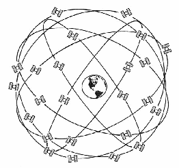
Currently running at full capacity, two global navigation satellite system (GNSS): GPS and GLONASS. Each of them consists of 24 main satellites and a spare. The orbits of the satellites are located at an altitude of about 20 thousand kilometers. Satellites continuously transmit signals containing information about their position and accurate time as well as the ranging codes to measure distances [1].

Figure 1 - The layout of the GPS satellites
Determination of the coordinates is performed using special satellite receivers, which measure time of the signal from multiple satellites to the receiver and the phase of the signal at the carrier frequency. Different measurement techniques can achieve required for this type of work accuracy and productivity [1].
Hydraulic structures – structures that use water resources with the appropriate equipment. Hydraulic structures have a number of features, in connection with which they are significantly different from those of other civil engineering projects:
the effect of water on the structure;
impact of hydraulic works of the surrounding area;
responsibility of hydro-structure;
individuality of hydro-structure;
the cost of hydro-structure [4].
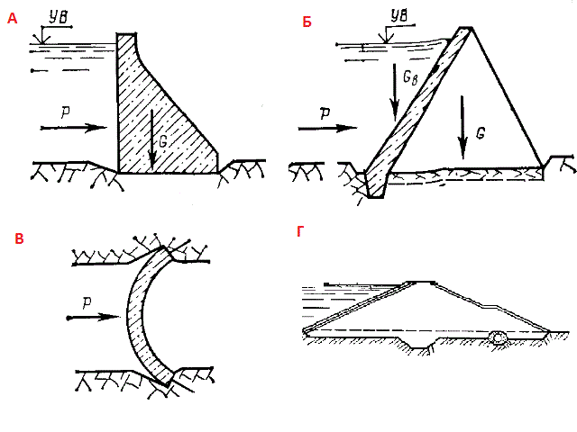
Dams are water retaining structures, that is, they raise the water level for a particular purpose. According to the construction of the dam are divided into concrete and dirt. Concrete dam, in turn, are divided into gravitational, moat and arched. Scheme shown in Figure 2.

Figure 2 - schematic designs of dams: a - gravity, b - buttress c - arch, d - ground.
Hydrotechnical structures require special methods of observation. Methods of observation are given in [6 - 9].
Deformation - change in shape of the observed object (warp, bend), or a change in its original position [7].
Displacement - change in the position of one point relative to another. In observations on the waterworks offset considered absolute if one point is located outside of the possible deformation of rocks, and a relative, if the two points are located in the zone of deformation of rocks or in the construction [7].
Displacement can be divided into vertical and horizontal. You can also select roll, twist, bend, incline, etc. For each type strain developed their own methods of measurement.
In determining the sediment on the following technologies: direct leveling, trigonometric leveling, hydro-leveling, micro-leveling.
In determining the horizontal displacements of such methods as: Casement measurement, triangulation, resection and other linear-angular construction.
For the observations are necessary to develop a method of measurement. The methodology should include: selection of tools and equipment, to establish the frequency of verifications and investigations, the calculation methods of measurement, setting the tolerance range of processing techniques [7].
By measuring the deformation strict requirements on the accuracy of the observations. The post-Soviet space, these requirements are specified in the standard documentation (GOST, SNIP). These standards are listed in [10, 11].
In particular, the concrete dam on rock and semi grounds horizontal displacement must be determined with an accuracy of 2 mm, and rainfall – 1 mm [10].
For embankment dams less accuracy requirements for them are required to determine the offset in the horizontal plane with a standard error of 3 - 5 mm and the pellets – 5 mm [11].
In addition, there are instructions on the frequency of observations. For example, for concrete dams precipitation should be monitored twice a year, the relative horizontal displacement of each month, and the absolute one to two times a year. For embankment dams, such observations are made once or twice a year [7].
Conclusion.
The task of monitoring deformations of the dam as up to date with the moment when these facilities become erect. At the moment there are quite a number of different methods of observation to a different accuracy in the task. However, the development of technology allows the use of new methods, and need to be studied.
References
Антонович К.М. Использование СРНС в геодезии. В 2-х томах. Монография. М. ФГУП «Картцентр». 2005 г.
Генике А.А, Побединский Г.Г. Глобальные спутниковые системы определения местоположения и их применение в геодезии. М: Картцентр, 2004 г. 355 с.
Соловьёв Ю.А. Системы спутниковой навигации. М:Эко-трендз, 2000 – 267 с.
Чугаев Р.Р. Гидротехнические сооружения Ч.1 Глухие плотины. Москва: Агропромиздат. 1985. – 318 с.
Гришин М.М. Гидротехнические сооружения Ч.1. Москва: Высшая школа. 1979. – 615 с.
Михелев Д. Ш. Геодезические измерения при изучении деформаций крупных инженерных сооружений. Москва: Недра. 1991.
Карлсон А.А. Измерение деформаций гидротехнических сооружений. Москва: Недра. 1984. – 245 с.
Пискунов М.Е. Методика геодезических наблюдений за деформациями сооружений. М.: Недра, 1980. - 248 с.
Зайцев А.К., Марфенко С.В., Михелев Д.Ш. и др. Геодезические методы исследования деформаций сооружений. - М.: «Недра», 1991. - 272 с.
ГОСТ 24846-81. Методы измерения деформаций зданий и сооружений. Москва: Государственный комитет СССР по делам строительства. 1986.
П 87 – 2001. Рекомендации по проведению натурных наблюдений за осадками грунтовых плотин. Санкт-Петербург: ВНИИГ. 2001
Мануэль Трехо Сото – Разработка методики анализа результатов геодезических измерений при наблюдении за осадками и смещениями крупных инженерных сооружений спутниковыми методами. Автореферат на соискание учёной степени кандидата технических наук. Москва – 2007 – 24 c. http://www.miigaik.ru/... – 23.04.2013.
Нгуен Вьет Ха. Разработка методики определения деформаций плотин гидроэлектростанций по результатам спутниковых геодезических измерений во Вьетнаме. Автореферат на соискание учёной степени кандидата технических наук. Москва – 2010 – 24 с. http://www.miigaik.ru/... – 23.04.2013.
Jacob O. Ehiorobo, Raphael Irughe-Ehigiator. Monitoring for horizontal movement in an earth dam using differential GPS. Journal of Emerging Trends in Engineering and Applied Sciences. http://jeteas.scholarlinkresearch.org/... – 23.04.2013
S.Erol, B.Erol, T.Ayan. A general review of the deformation monitoring techniques and a case study: analyzing deformations using GPS/leveling. ITU, Civil Engineering Faculty, Geodesy division. http://www.isprs.org/... – 23.04.2013
