
Abstract
Content
- Introduction
- 1. Theme urgency
- 2. Goal and tasks of the research
- 3. Planned results
- Conclusion
- References
Introduction
Normative monetary evaluation of the various categories of land used primarily for tax purposes. Many years of experience with the normative monetary evaluation as a definition of the tax base suggests that the methodological approaches that form the basis of the normative monetary evaluation correspond to the modern conception of the value of land, create the right conditions for the efficient and fair taxation of land. However, the process of the normative monetary value of land is not fully correspond to the pace of land reform and calls for further improvement [1].
1. Theme urgency
The use of geographic information systems to simplify the evaluation process and reduce labor costs. To date, impossible to achieve fully automated without human intervention, but even partial automation speeds up the process of normative monetary evaluation. The advantage of the monetary value of using geographic information systems is not only to save time, but also the possibility to combine it with other urban development: land and urban cadastre, master plan, etc [2].
2. Goal and tasks of the research
Goal: To automate the process of normative monetary evaluation based on GIS, the development of a mechanism that will facilitate the work as an appraiser and reduce the impact of an expert on the result.
Tasks of the research:
- Analysis of the monetary value of land in Ukraine and abroad in order to improve (for example, the post-Soviet countries, Europe and the Americas);
- Identify key algorithm automation monetary value;
- Testing algorithms in geographic information system ArcGis;
- Testing results on the example of Makeyevka.
3.Planned results
For today normative monetary evaluation in Ukraine does not meet international standards for evaluation (INC), the market supply of real estate is not evenly developed, which does not go to mass appraisal, which has been successful in most of the developed world. In the existing software systems normative assessment of the land there is a major drawback - by a qualified expert, and his own to put down local factors (balls) on the location of the land within the economic-planning zone, and it is a matter of great labor intensity of the monetary value of the land.
Such a way normative monetary evaluation of land has been and remains the most appropriate mechanism to taxation in Ukraine. However, a regulatory assessment is a very complicated process and requires some automation. It is planned to automate the process of selecting local coefficients, thanks to mathematical functions that will simplify the work of an expert at this stage. The main goal of this paper is to find the tools and technologies that can be applied in the automation of the assessment.
The expected outcome of the work is to automate the process of determining the local coefficient (km3) which takes into account the location of the land within the economic-planning zone. The coefficients are set according to the results pofaktornyh assessments of each group, taking into account the proportion of rentoobrazuyuschih factors in shaping the overall rental income within the locality and its economic-planning zones.
In traditional assessment techniques, the values of these coefficients are selected from the range set by the appraiser, and may significantly differ from reality.
When you automate this process in geographic information system ArcGIS ArcMap10, the values of these coefficients will be calculated automatically by the construction of buffer zones.
Buffer zones - polygons whose boundaries are separated by a certain distance from the borders of the original objects. For example, when evaluating the area occupied by residential development, the functions of ArcGIS can be created by walking around the area of public centers (schools, hospitals, kindergartens). Buffer zones can be created for point, line and area objects. In many cases, the distance from the boundary of the object to the landfill, can depend on the attribute data, for example, the width of the coastal zone, or the city's population. Also in ArcGIS provides the construction of several buffer zones of different radii, as well as the construction of intersection, union and difference [3].
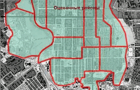
Figure 1 – Building a buffer zone
(animation: 4 frames, 5 cycles of repeating, 150 kilobytes)
The intersection of buffer zones to determine the thickness of the overlap factors for the evaluation of infrastructure development. This means that the larger the thickness of the slab, the higher the ratio of local assessment district. Based on this idea will algorithms automate this process.
Conclusion
In this master's work solved the practical problem, which is to identify the strengths and weaknesses of technologies and techniques normative monetary value of urban land in Ukraine, as well as the development and testing of mathematical models of process automation in the regulatory assessment of environment ArcGIS, for example Makeyevka.
This master's work is not completed yet. Final completion: January 2014. The full text of the work and materials on the topic can be obtained from the author or his head after this date.
References
- Доклад к дипломной работе [Электронный ресурс]. – Режим доступа: http://kyrator.com.ua/
- А. А. Євдокімов, С. В. Журавльова. Геоінформаціїні технології грошової оцінки земель населених пунктів. // Восточно-Европейский журнал передовых технологий 2/4(50) 2011.
- Тикунов В. С. Геоинформатика. Построение буферных зон [Электронный ресурс]. – Режим доступа: http://edu-knigi.ru/