Abstract
Content
- Introduction
- 1. Types of photogrammetric survey
- 2. Legal framework for the assessment of building`s physical condition and structures
- 3. Construction of photogrammetric model
- 4. An experimental part
- Conclusion
- References
Introduction
Modern advances in computer technology, as well as theoretical studies in imaging have made it possible to use digital techniques. Photogrammetric processes are fully automated through the use of digital images, which are obtained by scanning photographs or directly from digital metric cameras [1].
One of the central tasks of perspective directions in research are photogrammetry measurement and visual properties of digital stereo model [2]. Using digital cameras affect surveying technology , they influence on criteria of selecting the parameters for this analysis is based on algorithms for constructing and processing images.
All buildings (structures) are subject to periodic examinations and using of photogrammetric methods for these purposes will ensure reduction of work terms, the required accuracy, as well as the ability to perform the necessary measurements on a pair of images in the laboratory conditions without additional visiting an object, which will significantly reduce the cost of performing this type of work. Application of these methods is particularly important in the reconstruction of buildings, and also for tracking deformations of buildings to determine their suitability for use.
The purpose and objectives of the study. Compare the accuracy that can be obtained by customer-grade digital camera, using the normal and convergent methods to determine the physical condition of the building.
To identify the most effective type of photogrammetric survey, do the following practical problems:
- Analysis of the legal framework for the assessment of building’s physical condition and structures;
- Compare results of image’s modelling of convergent and normal geometry;
- Compare results obtained on the basis of a real experiment.
Object and subject of study. Object of study is the accuracy of the digital terrestrial photogrammetric survey. The subject of this study is to photogrammetric digital photography.
1. Types of photogrammetric survey
It is distinguished five major cases of capturing images: normal, equally deflected, convergent, and equally tillted (Fig. 1.1).
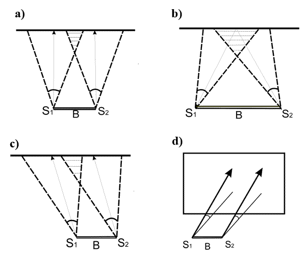
Figure 1.1 – Basic cases of capturing images
It is better to use convergent case in terrestrial digital photogrammetric survey, because it provides a large area of overlap (Fig. 1.2).
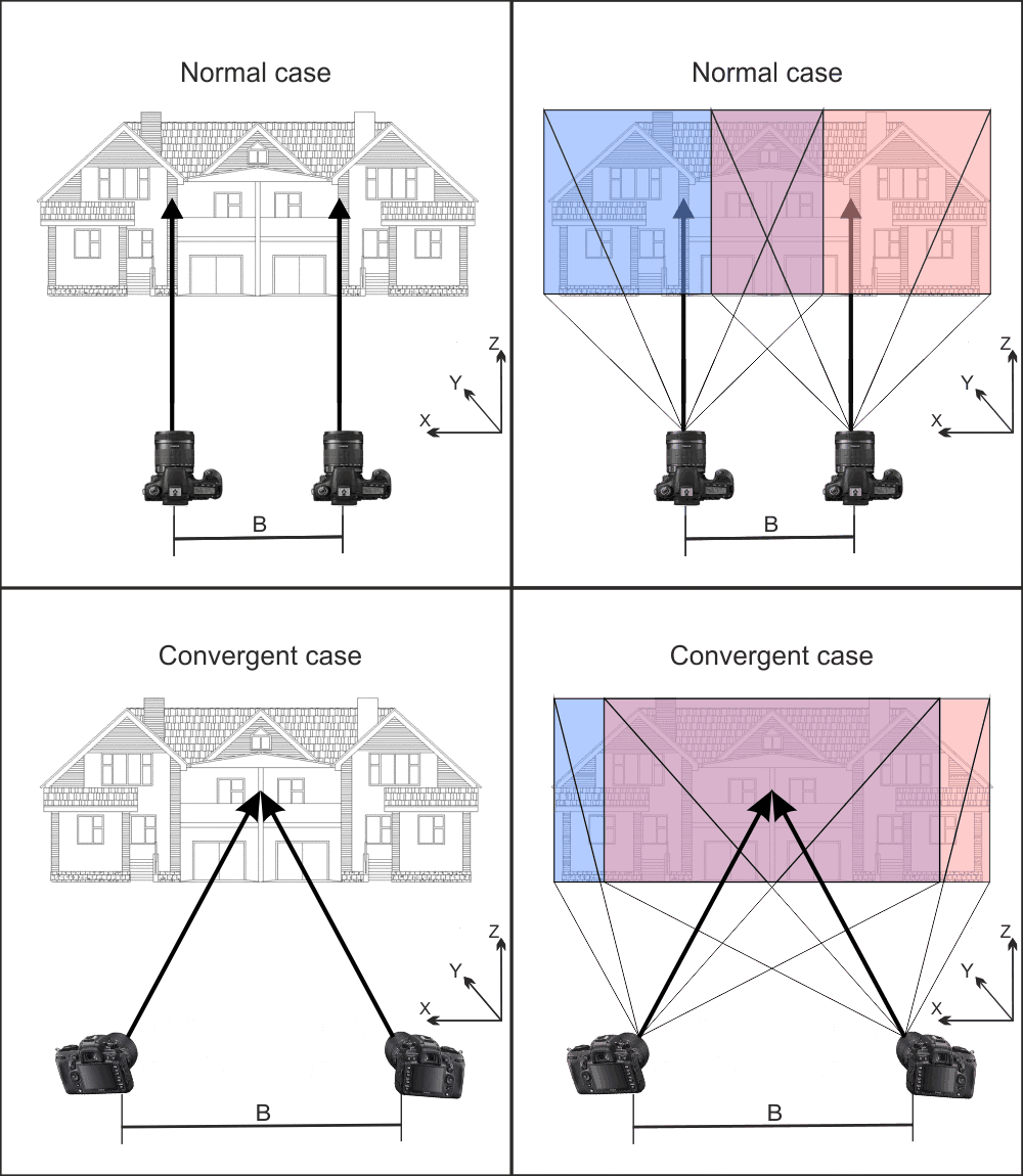
Figure 1.2 – Area of overlap in normal and convergent cases of photogrammetric survey
(animation: 4 frames, 10 cycles of repetition, 130 kilobytes)
2. Legal framework for the assessment of physical condition of buildings and structures
ОBuildings and structures examination is based on the following legal documents: Terms of surveys technical condition, assessment and certification of industrial buildings and structures
[5],
Protection from dangerous geological processes. Engineering protection of territories and buildings from landslides and avalanches
[6],
Instructions on the composition, development, and approval of design and estimate documentation for construction of enterprises, buildings and structures
[7] ], and others depending on the characteristics of the inspected object, and also we can use an Act About Architectural Activity
[8],
Act About regulation of urban development
[9] and other.
One of the documents regulating the activity of reconstruction is DBN B.3.2–2–2009 Upgrade, repair, restoration construction projects. Houses. Upgrade and Repair
[10] according to which the examination of constructions of foundations, underground and above-ground parts of residential buildings is mandatory for the development of projects of reconstruction and repair, and should include:
- Geodetic measurement units precipitate of foundations, as well as deviations of bearing and enclosing structures of buildings and parts of the vertically and horizontally;
- Evaluation of the technical state of the structures of the survey (technical report).
Thanks photogrammetric methods it is possible to construct a model of the building, on the basis of which will be reconstructed.
Thus, the scope of application of photogrammetric methods in the evaluation of the physical condition of the buildings is wide enough, and considered legal acts permitted to use alternative methods of obtaining accurate and most complete information about the object.
3. Construction image’s model
To construct the layout of images used building program layout pictures (Fig. 3.1)
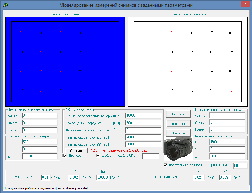
Figure 3.1 – The window of program, which makes photogrammetric model
The result of building image’s layout using programs will file *. del
. Which is used in further processing in software Block MSG.
Evaluation of the accuracy of the model is performed using software BlockMSG, on the basis of the data obtained and histogram was built (Fig. 3.2).
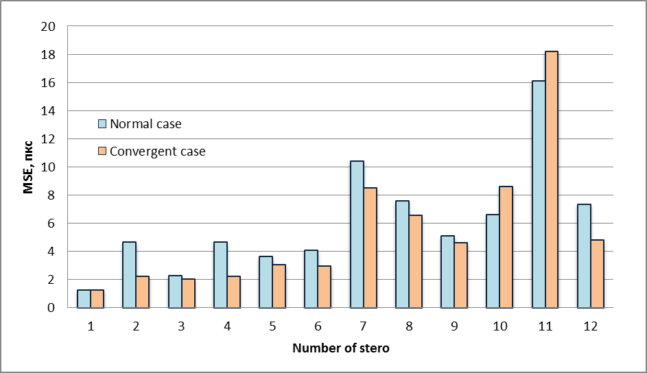
Figure 3.2 – Distribution of MSE using normal and convergent cases
Based on these data we can conclude that, under these parameters has the advantage of using a converged case. When full overlapping images focal length is not significantly affected by the use to improve the accuracy of a survey method of architectural structures.
4. An experimental part
The aim of this work was to compare kinds of photogrammetric survey, which are based on the real data.
Object is the facade of the church Zugresskaya, which was clamped with 5 control points (Fig. 4.1).
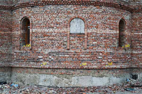
Figure 4.1 – A scheme of control points on the facade of the Church Zugresskaya
For taking images was used Digital Camera Olympus E20P with focal length 10424 px
Control points were determined using the instrument (Tab. 4.1).
| № | Name | Х,м | У,м | Z,м | Mx | My | Mz |
|---|---|---|---|---|---|---|---|
| 1 | ОЛ | -1,4218 | 76,4686 | 2,2187 | 0,002 | 0,0014 | 0,0003 |
| 2 | Ц1 | -0,5156 | 77,2908 | 1,2494 | 0,002 | 0,0014 | 0,0003 |
| 2 | Ц2 | 1,4146 | 77,7293 | 1,2614 | 0,002 | 0,0014 | 0,0003 |
| 4 | Ц3 | 2,7845 | 77,3826 | 1,2596 | 0,002 | 0,0014 | 0,0003 |
| 5 | ОП | 3,8527 | 76,4688 | 2,2437 | 0,002 | 0,0014 | 0,0003 |
Then using the module Triad Delta measurements were made of pairs of images. Equalizing and accuracy estimation was carried out using the module Block MSG. Comparison of the data on the protocol given in table 4.2.
| Average errors to photo coordinates, m | Error of unit weight, m | Average errors to on control point | Average deviation after connecting models, m | ||||
|---|---|---|---|---|---|---|---|
| X | Y | 2d | in hight | Check points | Control points | ||
| Normal geometry | 0,054 | 0,013 | 0,079 | 0,031 | 0,032 | 0 | 0,05 |
| Convergent geometry | 0,056 | 0,024 | 0,087 | 0,03 | 0,021 | 0 | 0,05 |
Based on these data we can conclude that when shooting buildings using converged positioning accuracy is higher than shooting in the normal way.
Conclusion
Based on these data we can conclude that the use of convergent case is preferable to perform a physical assessment of the building for several reasons: provides a large area of overlap, have better accuracy then normal
I am planning to conduct additional research with building layout of images.
At the time of writing the abstract, Master’s work is not completed yet. Full text of the work and materials on the topic can be obtained from the author or his manager after December 2014.
References
1. И. С. Кацарский О цифровой фотограмметрии и перспективах ее применения
/ ГИС София
, Болгария. – [Электронный ресурс] – http://www.geoprofi.ru
2. Ю. Ф. Книжников, Р. Н. Гельман Компьютерная система для измерения цифровых стереопар при решении нетопографических задач и научных исследованиях
/ Геодезия и картография. – 1999 – № 2. – С. 136–149. – [Электронный ресурс] – http://www.stereo-pixel.ru
3. Производственный и научно-исследовательский институт по инженерным изысканиям в строительстве Руководство по применению фотограмметрических методов для составления обмерных чертежей инженерных сооружений
/ Москва 1984.
4. Инструкция по производству маркшейдерских работ
/ М. Минский. – М.: Мир, 1971. – 364 с.
5. Правила обстежень, оцінки технічного стану та паспортизації виробничих будівель і споруд
/ Зареєстровано в Міністерстві юстиції України 6 липня 1998 р. за N 23/2863.
6. ДБН В.1.1–3–97 Защита от опасных геологических процессов. Инженерной защиты территорий, зданий и сооружений от оползней и обвалов.
7. Строительные нормы и правила Инструкция о составе, порядке разработки, согласования и утверждения проектно-сметной документации на строительство предприятий, зданий и сооружений
СНИП 1.02.01–85 / Госстрой СССР Москва 1988.
8. ЗУ Про архітектурну діяльність
/ ВідомостіВерховної Ради України (ВВР), 1999, N 31, ст. 246.
9. ЗУ Про регулювання містобудівної діяльності
/ Відомості Верховної Ради України (ВВР), 2011, N 34, ст. 343.
10. ДБН В.3.2–2–2009 Реконструкция, ремонт, реставрация объектов строительства. Жилые дома. Реконструкция и капитальный ремонт.
