Content
Relevance
Coal occurs in the depths of a reservoir, ores – in the form of veins, lenses, nests, reservoirs, and oil shale, salt, peat – in the form of layers and
lenses. Plast – congestion in subsurface resources, limited to two close parallel planes and having a large area of the spread compared to the power
(thick accumulation).
If the coal seam consists of a single coal, it has a simple structure. In most cases, the reservoir is divided layers – thin layers of waste rock – for
coal
pack, and has a complex structure. The number of packs in coal seams varies from unit to tens and hundreds. The planes in which the individual layers, or layers of rock
contact with each other is called bedding planes.
Purpose and research problems
Purpose – research in the areas of coal seams splitting through the application of mathematical statistics, geometry, and of quality control of mineral resources, based on
characteristic variability of reservoir deposits
Research problems:
1. Research methods of quality control of mineral resources and the geometrization of coal seams.
2. Practical application of the results to specific examples and calculation of reserves.
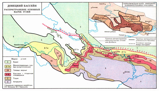
Considering the layered strata of Donbass coal basin (Fig. 1), which is characterized by the formation of concretions, vein introduction in coal beds of sandstone.
And so as a result of non-uniformity (in space and time), the signs and magnitudes of the amplitudes of the vibrational motions of the squares of peat formation is a
splitting of coal seams in the individual layers and thinning directed towards the most intense portion of peat formation and sinking to the peripheral portion thereof.
Geometrization in connection with the above features of the Donbass coal seams of coal formation, includes a series of sequential steps in the preparation
Mining and processing geological information[1–3]. It should serve as the basis for determining the boundaries of the counting of coal reserves and forecasting quantitative
and qualitative indicators
stopes that the end result will make it possible to assess a useful component of coal bed.

Figure 1. Donetsk coal basin
Main content of work
The first section of the master's work is devoted to the study of issues related to the assessment
indicators of coal deposits based geometrisation review practical assessment of coal reserves [8–11]. Results formation testing exploration wells
It should be viewed as a system of irregularly spaced data which are windows missing information and data coverage inequality testing of packs and
interlayers [5]. Heterogeneity testing area, the nature of the distribution and scatter of values the indicators for the formation of ideas about
the coal seam
require the use of different methods of creating topographic surfaces. Particular attention should be paid to the detail study of the laws
dissemination of indicators of coal, the use of theory and practice estimating reserves, exploration assessment information without increasing the volume of
exploration drilling.
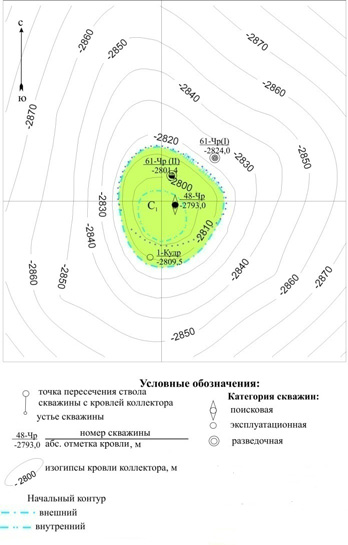
It should be noted that the results of testing will take into account the rules of sampling (Fig. 2).

Figure 2. Testing of wells
The second section of the master's work is planned methods of quality control of mineral resources and the geometrization scheduled to perform complex
coal, which is to establish the relationships between indicators of hurricane conditions culling trial, assessment theoretical and
empirical distributions, test data independence, establishing correlations [4]. To reject hurricane trial scheduled use
a method based on the comparison approximated, which is obtained from the solution the Central differential expression through a
balanced
the sum of the sampling points in the surrounding. Choosing the adjacent points are 1 km radius circle centered at the point of measurement. The radius of the circle,
equal to 1 km, taken as twice the average distance between wells on the classification of certain stocks. Conditions rejection expressed system of equations:

Figure 3. Set of equations
where: Х0 , У0 – the average values of the coordinates of points; Хi ,
Уi – the current values of the coordinates of points;
bi – weight;
аi – the value of the test indicator of the well;
а0 – the average value of the test indicator; n – the number of samples studied parameters; s – mean square error in determining the test indicator
(animation: 5 frames, 5 cycles of repetition, 20 kilobytes)
The third section of the master's work is planned consideration of the geometrization of coal on the basis of different methods of mathematical and statistical
analysis
(Method of trend analysis, cluster analysis and the method of assessment point) [1]. It meets the diverse requirements of the construction of the
complex on the basis of score evaluation
ratings. The scores attributed to the beginning levels, may be obtained in different ways: either based on prior agreement, or on the basis of the ranking
values indicators of economic activity.
The fourth section is planned to calculate the balance sheet and sheet reserves within the mine field for the test to be taken raw
plots way delineation of individual blocks, geometrical figures on research. Contouring reserve calculation is the basis for determining the amount of
balance sheet and sheet reserves, establish the spatial distribution of natural types, establishing the level of study and inventory values
geological parameters.
Conclusion
At the moment my master's work is not yet complete. On the detailed results will be available after the defense at the Department of Surveying in January 2016.
References
- Филатова И. В., Ковган Е. Н. Опыт автоматизированного построения границ марок угля с использованием экспертной системы // Сучасні технології маркшейдерського забезпечення раціонального і безпечного ведення гірничих робіт. – Донецьк: ДонНТУ. – 2002. – с. 40–43.
- Филатова И .В., Ковган Е. Н. Методика оконтуривания фигур подсчета запасов // Сучасні технології маркшейдерського забезпечення раціонального і безпечного ведення гірничих робіт. – Донецьк: ДонНТУ. – 2002. – с. 31–33.
- Оглоблин Д. Н., Герасименко Г. И., Акимов А. Г., Зоря М. Н., Козловский Г. И., Мирный В. В., Могильный С. Г., Музыкантов В. К., Никольский С. Л., Папазов М. Г., Травник С. Ф., Фисенко Г. Л., Шевердин П. Г., Шурыгин В. И. Маркшейдерское дело. – 3-е изд.перераб. и доп. – М.: Недра, 1981. – 704 с.
- Мирный В. В., Филатова И. В. Установление границ марочного состава углей для шахт Донбасса // International Society for Mine Surveying XIII International Congress Budapest, Hungary, 24–28 September 2007. – 2007. – P. 098.
- Петров Н. С. Маркшейдерское дело: Учебник для горных техникумов. – Ч. I. – М.: Углетехиздат, 1951. – 402 с.
- Кирюков В. В., Дмитриев А. М., Очкур Н. П. Геолого-промышленная оценка угольных месторождений: Учебное пособие. – Л.: ЛГИ, 1987. – 97 с.
- Клер В. Р. Обработка материалов разведки месторождений угля. – М.: Недра, 1980. – 173 с.
- Долгий В. Я. Показатели качества углей добытых на шахтах Украины/ В.Я. Долгий, А. А. Кривченко, М. Д. Шамало, В. А. Долгая –
Уголь Украины
, 1999. – № 8 – с. 18–22
- Жуков В. Е. Теоретическое и экспериментальное исследование совершенствования технологии очистных работ и отработки шахтных полей в Центральном районе Донбасса. Автореф. дисc. докт. техн. наук. – М.; ИГД им. Скочинского, 1973. – 30 с.
- Мирный В. В., Филатова И. В. Построение границ марочного состава углей на основе балльной оценки // Горная геология, геомеханика и маркшейдерия. – Донецк: УкрНИМИ НАН Украины. – 2004. – с. 335–338.
- Попов В. Н., Руденко В. В. Геометрия и квалиметрия недр в системе горных наук: состояние и направления развития // Маркшейдерский вестник. – 1999. – № 1 (27). – с. 29–33.


