
Abstract
Content
- Introduction
- 1. The relevance of the work
- 2. The practical utility
- 3. The purpose and objectives of the study, expected results.
- 4. Displacements and deformations of the earth's surface from the underground mining
- 4.1. Principles of Forecasting displacements and deformations
- 4.2. These field observations
- 5. Designing the system before the effect of mining on the area
- 5.1. Selecting a design environment
- 5.2 Development of thematic layers and databases
- 6. Practical application of the complex
- Conclusion
- References
Introduction
A characteristic feature of the mining towns are areas to earn coal mining enterprises in the course of their work. The processes of displacement, strain and elevated groundwater levels cause mechanical damage in buildings, resulting in a risk of exploitation of the damaged urban areas.
1. The relevance of the work
Today is restructuring the coal industry, in which a large number of mines, the operation of which is unprofitable under current conditions, closed or preserved. Mass closure of coal enterprises leads to negative environmental processes and phenomena. Instrumental monitoring of geomechanical processes in the liquidation of these enterprises are required, because the problems arising in the elimination of certain mines include flooding undermined territories of hole. One of the urgent problems arising in the conditions of increasing anthropogenic impact in urban areas, is to assess the dynamics of the development of man-made topography and associated deformations of the earth surface undermined territories. Also, while closing the mines adds new complexity exploitation areas caused by the changing nature of the deformation of the earth's surface, in particular – the intensification of the process of displacement.
2. The practical utility
Underground coal mining leads to displacements and deformations of the earth's surface, respectively, and the facilities within the area of earning.During flooding rock strength properties are reduced, which may lead to loss of equilibrium steady earth formation and activation of displacement. As a result, possible deformation of the earth's surface, cracks, ledges and failures.
Adverse changes in the environment need to be prevented and existing-control. Violations of components of the environment as a result of the operation of mines, subject to long-term monitoring. One of the components of the overall monitoring system is geomechanical, provides information on the state of the rock mass and the Earth's surface, and is based on the results of surveying observations. This displacement and deformation of the earth's surface is a quantitative assessment of all occurring in an array of geomechanical processes [1].
3. The purpose and objectives of the study, expected results.
The purpose of the study is to analyze the long-term observations of the surface subsidence above abandoned horizontal workings and experimental modeling of the results.
The main objectives of the study:
- Analysis of mathematical methods for constructing 3D digital surfaces.
- Developing an effective simulation techniques mo surface subsidence.
- Predicting their further settling th undermined areas Budennovsk and Proletarian s district of Donetsk.
- Estimation of the probability of flooding of the territory in question.
- Analysis Received results and formation recommendations.
The object of study – the territory of the closed mines Budennovsk and proletarian districts of the city of Donetsk. Subject of research – the processes of deformation of the earth's surface at its sequential podrabotke mining.
4. Displacements and deformations of the earth's surface from the underground mining
Mining operation violates the natural state of rock massifs, whereby the last out of balance, deformed and moved [2, 3].
4.1. The main types of deformations and their influence on the surface of moonlighting
The impact of part-accounted priproektirovanii buildings are sdvizheniyai deformation of the earth's surface, which are divided into the following types (Fig. 4.1) [4]:
- settling h, mm – vertical component vector move point surface;
- the slope i, mm/m – characterizes unevenness distribution subsidence;
- curvature (convex, concave) r, 1/km, or radius of curvature R = 1/r, km – unevenness distribution slopes in section trough displacement;
- horizontal displacement x, mm – Horizontal component vector move point surface;
- relative to a horizontal compression or tensile strain e, mm/m – unevenness horizontal displacement in trough;
- step height h, sm.
When the diagonal arrangement of the building or structure with respect to the formation liniiprostiraniya further to consider the impact of part-time work because of the deformation of the earth's surface:
- curling S, 1/km;
- abrasion g, mm/m.
In cases envisaged by the project, it takes into account the rate of increase of ground deformation u mm/m month.
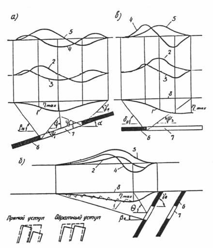
Figure 4.1 – Types of displacements and deformations of the earth's surface
a – a vertical section across the strike at oblique zaleganiiugolnyh layers; b – the same as at the steep occurrence of coal seams; c – a vertical section along the strike of layers;
1 – settling curve; 2 – diagram of the slopes; 3 – curvature graph; 4 – diagrams of the relative horizontal deformation; 5 – diagrams of horizontal displacement;6 – layer; 7 – development of wastewater treatment; 8 – position of the earth's surface to the part-time work; hmax – maximum subsidence of the earth's surface; b0, g0, d0 – boundary angles of displacement; y1, y2, y3 – the corners of the full displacement; q – angle of maximum subsidence; a – angle of dip
Depending on the development of deformation of rocks and earth surface are smooth or centered character. The concentration of strain in some areas is education in the formation on the surface of the earth cracks and ledges that have a very unfavorable effect on the undermining objects [5]. Sometimes on the earth's surface are formed gaps.
4.2. Principles of Forecasting displacements and deformations
The idea of research is to determine the factors that influence the accuracy of the prediction of displacement and deformation and improve existing methods of calculation taking into account the most significant of them; Scientific substantiation and working methods of the automated calculation of deformations of the earth's surface during the operation and liquidation of coal mines; adaptation of existing and improved techniques, calculation formulas for automated methods of calculation; development of software modules for the mapping of the forecast ground deformation on the influence of mining in the treatment workings of coal mines.
For a more accurate prediction using comprehensive research methods, including analysis and generalization of the results of previous studies, existing calculation methods, system analysis processing, transformation, mapping and surveying geomechanical data [6], computer modeling of subsidence, a comparison of the results with observational data on coal mines.
When displacement of the earth's surface the main indicators to predict and assess the condition of buildings and structures are [7]: subsidence of the earth's surface, the radius of curvature and horizontal deformation in the foundations of buildings [8].
5. Designing the system before the effect of mining on the area
The movement, subsidence and collapse of rocks under the influence of developments require mandatory surveying observations. In order to simplify operation.
5.1. Selecting a design environment
To accomplish the task, the program was used QUANTUM GIS – a free cross-platform software with open source [9]. Runs on Linux, Unix, Mac OSX, Windows and Android, and also supports many vector, raster formats, databases, and has broad capabilities. QGIS offers a growing set of features implemented in the kernel and modules. The program provides the ability to visualize, manage, edit and analyze data that is extremely user-friendly application for both developers and users.
5.2 Development of thematic layers and databases
Changes to the parameters of the deformation field produced by teachers of the Department of Surveying and Geoinformatics as a result of observations, fed by special monitoring stations, consisting of specialized lines. This reduces the reliability of the conclusions, since measurements were taken over the entire area is not territory. From the observation results in the master work by data interpolation, and the value was determined by sedimentation rate. In addition to displaying graphical information describing geomechanical condition of the territory in different interavaly time, a database was established quantitative characteristics of objects (the number of storeys of buildings, construction material, etc.).
The process of displacement of rocks and earth surface has been studied according to the instrumental observation and analysis of a large factual material. Graphical basis for DEM steel raster topographic maps and plans of the combined mining and surface areas under consideration provided by the Department of Geoinformatics and Geodesy [10]. Since to use the information in the GIS need to transform it into a digital form, materials for scanners scanned with high resolution. Digitizing the material carried by the images with a resolution of 300 dpi in the multipurpose package Quantum GIS. To assign an object in the real coordinate crosshair grid lines rigidly tied to a coordinate system. Thus, the primary information was broken down into thematic layers having corresponding attribute and semantic information:
- floor contour describing the topography;
- floor contour waste coal seams;
- floor markings mining;
- covering buildings and structures; Floor low-rise buildings;
- floor streets;
- coat of green spaces;
- covering railways and power lines;
- floor mine dumps and exploration wells;
- floor shafts.
Since in research to collect large amounts of attribute information, there is a need for sorting and ordering it in a database.
The main objective of the database management system is to provide users with an abstract view of the data by hiding the specific characteristics and storage management. So before you create tables, forms, and other objects necessary to define the structure of the database.
After analysis of the problem has been developed following the structure of the program:
- The main form – the window from which you can get to two other forms;
- The shape "Buildings" – the main form for information about the buildings. It contains general information about the inspection of buildings, repairs, etc;
- Shape "Stations" – called with the main form. It contains information about the observation stations, leveling motions frames, as well as of the date of filming.
6. Practical application of the complex
Implemented in practice, a set of measures for monitoring subsidence undermined areas allows us to consider not only the current strain and make short-term and long-term forecasts on the basis of field observations and surveying collected attribute information. The use of geographic information technologies simplifies and accelerates the research helps to sort and organize the data and renders graphical information that allows us to construct a visual model of all originating from the object of research processes.
Figure 6.1 – Realization software package
(animation: 5 frames, 7 cycles of repeating, 212 kilobytes)
Monitoring of territories is undermining the long-term research, because forecast, and most importantly – the prevention of negative influence requires constant monitoring. In situ observation of surface subsidence should be carried out for decades, introducing amendments to the results, as well as adjusting the forecast of further strains for the changes in the geological environment. It may be damping subsidence, changes in the groundwater level, the formation of new failures, benches and more.
Also, the observation of core lines is sufficient to construct a spatial model, but for a more accurate prediction is necessary to use modern methods of measurement, such as satellite radar interferometry technology, which allows to obtain data across the controlled area.
Optimization and ordering of the information received, an increase in the database to complete the picture, a deeper analysis that allows to increase the accuracy of the forecast – the prospect of further work. The length of the studies on time presents us with new tasks that will introduce protective measures and repair work for the relief of the existing surface deformations and objects placed on it and prevent the emergence of new ones.
Conclusion
Implemented in the course of the study a set of measures for monitoring undermined territories, linking the information received in the GIS allows to reach a higher level of data collection and analysis on the development of the process of displacement, which allows continuous monitoring of the Earth's surface and located on the safety of her buildings.
Using geographic information systems makes it quite quickly and visually assess the impact of underground mining on the surface of the earth. The results of observations made it possible to establish the existence of the earth surface subsidence caused by the activation of geomechanical processes, as well as to determine the values and speeds their development. The study analyzed the mathematical apparatus of geoinformation modeling surfaces and considered adaptive model estimation and forecasting of sedimentation undermined territories. Also, in the estimation of the probability of flooding and land Budennovsky Proletarian areas of the city of Donetsk. The study analyzed the mathematical apparatus of geoinformation modeling surfaces and considered adaptive model estimation and forecasting of sedimentation undermined territories. Also, in the estimation of the probability of flooding and land Budennovsky Proletarian areas of the city of Donetsk.
While writing the essay study is not yet completed. The final results will be presented in December 2016 on the protection of the master's work.
References
- Гавриленко Ю.Н. Изучение сдвижений и деформаций земной поверхности в сложных горно-геологических условиях Донбасса // Науковi працi ДонНТУ: Серiя горно-геологiчна. Випуск 62. – Донецк, ДонНТУ, 2003. –c. 34-37.
- Публикация «Общий подход к оценке недвижимости, подверженной влиянию подземных горных работ» [Electronic resource] – Access: http://snt.com.ru/obshchiy-podhod-k-ocenke-nedvizhimosti-podverzhennoy-vliyaniyu-podzemnyh-gornyh-rabot
- СНиП 2.06.15-85 – Инженерная защита территории от затопления и подтопления [Electronic resource] – Access: http://infosait.ru/norma_doc/1/1893/index.htm
- СНиП 2.01.09-91 – Здания и сооружения на подрабатываемых территориях и просадочных грунтах [Electronic resource] – Access: http://www.vashdom.ru/snip/20109-91/
- Писаренко М.В. Определение ожидаемых оседаний земной поверхности с использованием ГИС-технологий [Electronic resource] – Access: http://www.giab-online.ru/files/Data/2009/12/Pisarenko_12_2009.pdf
- ПБ 07-269-98 – Правила охраны сооружений и природных объектов от вредного влияния подземных горных разработок на угольных месторождениях [Electronic resource] – Access: http://meganorm.ru/Data2/1/4293834/4293834132.htm
- Воробьев А.В., Кашеварова Г.Г. Адаптивные модели краткосрочного прогноза оседания земной поверхности и определение наиболее неблагоприятного положения здания в мульде сдвижения [Electronic resource] – Access: http://engstroy.spb.ru/index_2013_09/02.pdf
- Шнеер. В.Р., Иванова Л.А., Басин М.П., Трифонов А.В. Оценка ущерба от подработки городов и поселков при сосредоточенных деформациях земной поверхности [Electronic resource] – Access: Yandex.Documents
- Руководство пользователя QGIS [Electronic resource] – Access: http://www.qgis.org/ru/
- Соловьев А.А. Трехмерное моделирование поверхности и угольных пластов территорий закрывающихся шахт Буденновского и Пролетарского районов г. Донецк // Магистериская работа ДонНТУ [Electronic resource] – Access: http://masters.donntu.ru/2004/ggeo/solovjov/