
Abstract
Содержание
- Introduction
- 1. Formulation of the problem
- 2. Goal and tasks of the research
- 2.1 Source model object
- 2.2 Hierarchical metadata catalog
- 2.3 Geospatial and attributive data model
- References
Introduction
The modern development of information technologies has contributed to the accumulation of a large number of geospatial information by organizations and departments, which is represented in various types and systems, is currently searching for the most interesting, in terms of system organization, method, allowing easy and effective use of global and local networks for data aggregation and their use in distributed information systems. The latest research on the use of single data warehouses for geospatial and attributive information allows additional steps to a single presentation of data, methods of efficient processing, use of information, as well as easy access to obtaining the necessary information.
1. Formulation of the problem
As a basis for building a database, several types of their construction are used, the main ones are:
- Building a single database system;
- Building a central database.
Creating a single database by copying information from all sources into a single data warehouse allows you to access data, regardless of the availability at a given time of the remote source. The negative side of this approach is large amounts of data, which must be stored and transferred to a single repository. This amount of information requires additional methods to ensure its and correctness. The central database of the system works by the principle of collecting certain headers of the system and subsequently obtaining information directly from a remote source. This design allows us to present the database as a set of relatively small databases,integrated through some application or other "generalized" database.
2. Purpose and objectives of the study
The purpose of modeling the structure of a geodatabase is to create just such a data structure that is capable of being consolidated metadata of the geodata of the distributed information and telecommunication system.
The metadata package is based on the following geodatabase information:
- The identifier of the metadata file or metadata records in the database.
- The standard used to describe metadata
- The language of metadata compilation;
- Date of metadata compilation
- Information about the side that delivers metadata.
The list of these data allows you to clearly define the object of geodata and make direct reference to it. The purpose of modeling the structure a geodatabase is the creation of a data structure that is capable of storing metadata of distributed geodata information and telecommunication system.
Using metadata to describe the elements of the system allows you to present information in the most convenient form, with the opportunity to present the data in such a way that it is possible to make a connection between them and the hierarchical catalog.
The simple placement of metadata in the geodatabase structure of a distributed information and telecommunications structure is insufficient, that a simple conglomeration of data will only complicate the work of the system. As a solution to the problem of finding the required information in a geodatabase you must select the method for sorting data in the geodatabase. On the basis of system analysis, it is concluded that the representation of a wide range of different data in the form of a hierarchical list is most convenient in terms of access to user data. Methods for constructing hierarchical data are given, as well as hierarchical structures for representing geodata. In order to solve the problem of centralized access to data, their classification, unification and Defining properties and methods for their processing uses the data catalog. The data catalog is a tree-like hierarchical structure, in which at all levels of the hierarchy are all the elements of the system. Moreover, it should be noted that the elements of the system are not always elements of the hierarchy.
Studies are being conducted to determine the most efficient way to store hierarchical data in databases. The Simplest Simulation Method structure implies a simple recursive passage through the tree and obtaining information about all structures. Modification of a simple method is a load recursive table with additional data. These data contain useful additional information, such as the path from the very top to the section, the nesting section, the number of children, the highest level, and everything that may seem necessary for the development of the program.
2.1 Source model object
The source object model using software interfaces is given in accordance with the Object Model of the documents. As an example, you can lead the processing of objects using additional software already on the user side (for example, DHTML, a dynamic markup language) at the last stage.
Transformations of system data are carried out using algorithms to reduce the correspondences of data models. The original data model is converted to one from possible variants of the data model of the Internet page (HTML, DHTML, XML, GML). The final document is the Document Object Model (DOM) and its extensions.
Data conversion is performed in accordance with the established correspondences of the objects of the original object model and the Document Object Model, which is finite for the transformation. A model for the representation of the metadata catalog of geodata in the form of a tree-like hierarchical structure is developed. The model of the geodatabase structure of the information and telecommunication system, the model of access to data and their processing, as well as the functional scheme information and telecommunication system for working with the developed geodatabase. The basic schemes and algorithms of work are developed information and telecommunication system, on the basis of which the modules of this system have been implemented.
2.2 Hierarchical metadata catalog
The considered hierarchical catalog of system metadata represents the basic design of the system through which data manipulations are performed. A hierarchical directory is associated with storing and accessing data. As a basis for the hierarchical directory, there can be a natural hierarchy of documents. For geodata, this hierarchy can be aligned in scale, as well as in the coverage of territories. A hierarchical directory is a description of the metadata of information, which has a system of distributed data sources. Metadata also contains a number of additional parameters in addition to the basic properties of information. The metadata structure of the geodatabase of the information and telecommunication system is shown in Fig. 2.1.
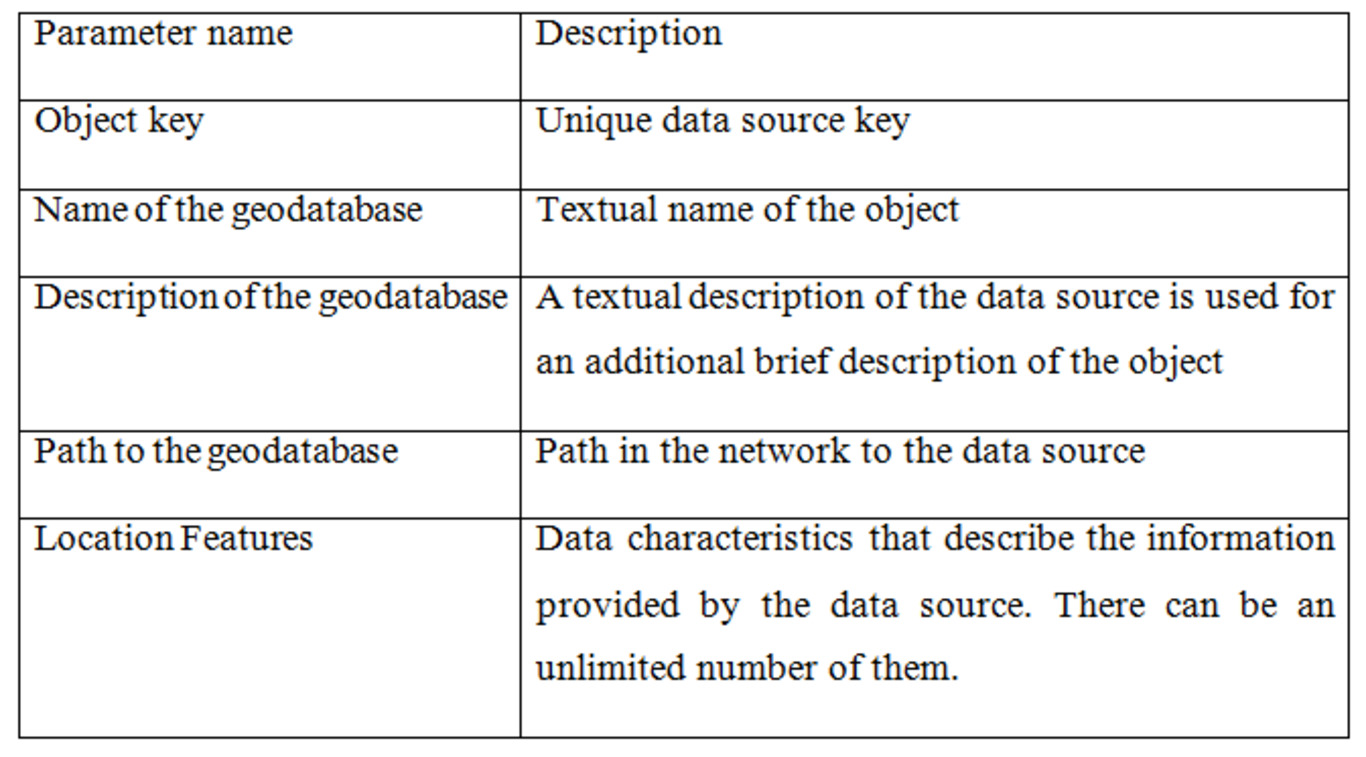
Figure 2.1 - Metadata structure of the system
Using metadata to describe the elements of the system allows you to present information in the most convenient form, with the opportunity to present data in such a way that it is possible to communicate between them and the hierarchical directory. It should be noted that the characteristics of the objects can be located in separat tables of the geodatabase, which will allow using attribute value dictionaries. The DB model is shown in Fig. 2.2.
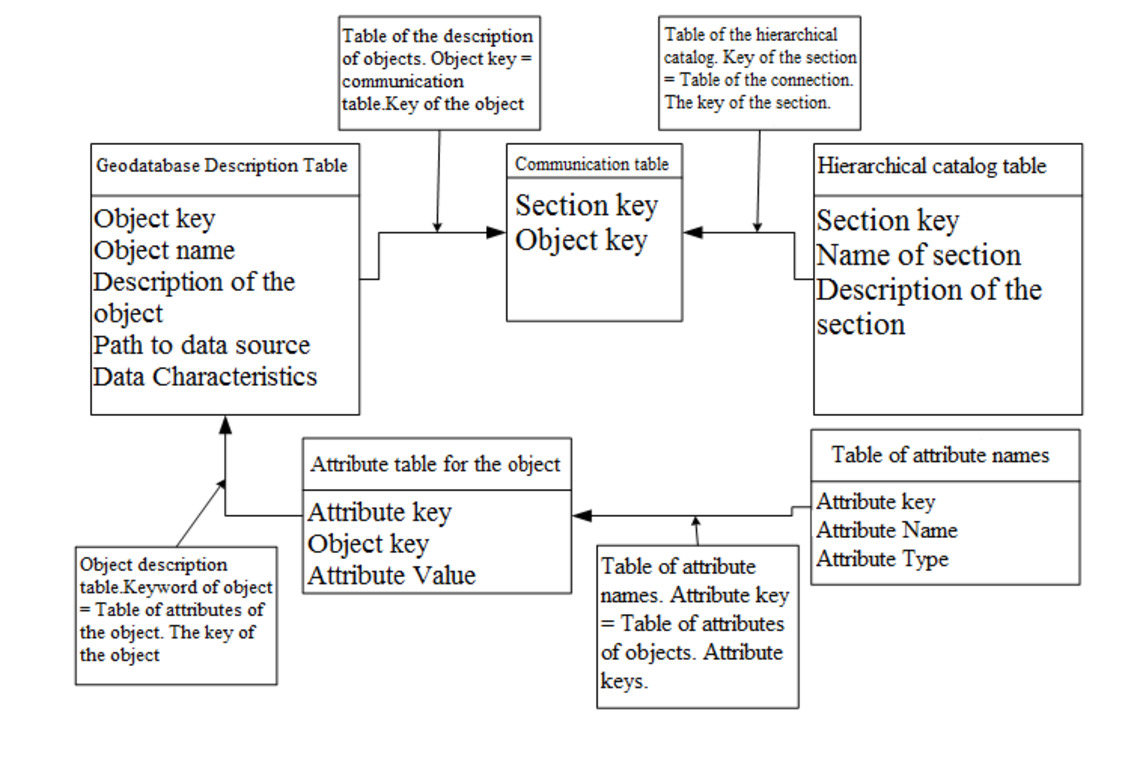
Figure 2.2 - Metadata Catalog Table Structure
2.3 Model of geospatial and attributive data.
In remote data sources, the geodata are stored in a variety of ways. For work it is necessary to use an additional transformation between object models, in which the data is presented, and the existing object models of web documents. The model is presented in Fig. 2.3
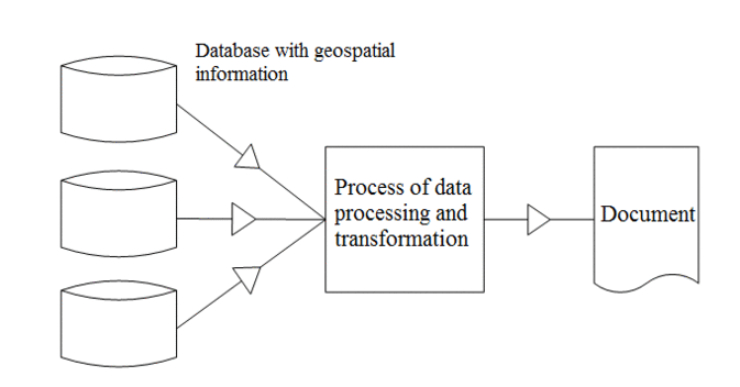
Figure 2.3 – Functional diagram of data conversion
In the functional diagram shown in Fig. 1.2, a block of the process of data processing and transformation was marked. This function block contains conversion algorithms data - the methods of translating data from the source object model to the document object model (DOM). The source model of the source using the programming interfaces is give in accordance with the Object Model of documents. An example is the processing of objects using additional software already on the user side at the last stage. Transformations of the system data are carried out using algorithms to reduce the correspondences of data models. The original data model is converted to one of the possible variants of the data model of the Internet page (HTML, DHTML, XML, GML). The final document object model (DOM) and its extensions are used. Transformation data is carried out in accordance with the established correspondences of the objects of the original object model and the Document Object Model, which is the final one for the transformation.
Transformation of attributive information in some cases may not be required at all (Figure 2.4), since the information presented as attributive information in mostof cases is stored in relational database tables, to which you can connect directly. This approach is also possible, since during all data transformations a reference to the original keys that can determine the information object after its transformation is retained. Thus, we get, as it were, a "through" scheme of motion information through the conversion unit, which in this case only affects the translation of data from remote sources into the requested document.
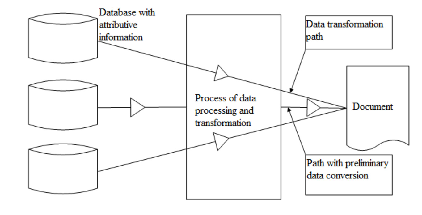
Figure 2.4 – Transformation of attributive data
Conclusion
In the course of the conducted studies, the main task was solved, the structure of geodatabases of information and telecommunication systems was investigated and developed, and also applied to practice methodology for designing a geodatabase designed for consolidated storage of distributed geodata. The work analyzes existing information and telecommunication systems using geodatabases, a classification of their main types is defined, as well as ways to improve their quality on the basis of analysis known research and practice of use. A model for representing a metadata catalog of geodata in the form of a tree-like hierarchical structure was developed. The model of the geodatabase structure of information-telecommunication systems, the model of access to data and their processing, as well as a functional diagram of the information and telecommunications system for working with the developed geodatabase. The basic schemes and algorithms of the information- telecommunication system have been developed, on the basis of which the modules of this system have been implemented. The solution to the problem of representing geospatial data by applying structured catalogs of metadata allows to increase the efficiency of distributed information and telecommunication systems, raise the system's performance in the field of data processing and storage and reduce the load on communication channels, and increase the convenience operation and search of the necessary information.
References
- Ivannikov AD, V.P. Kulagin, A.N. Tikhonov, V.Ya. Tsvetkov, Geoinformatics, M: MaxPress, 2001 - 349 p.2. "What is ArcGIS?", ESRI, USA, 2002
- Tsvetkov V.Ya. Geoinformation systems and technologies / Textbook. Moscow: MGUGiK, 2000. - 69 p.
- Kraak Menno-Yan, Ferjan Ormeling, Cartography. Visualization of geospatial data, M.: Science World, 2005.
- Van Steen M., Distributed systems. Principles and paradigms, St. Petersburg, Litter, 2003.-887 p.
- Siha Bagui. Object-oriented databases: achievements and problems // Open Systems, 2004, No 03
- Markov G. T. Antennas. M. L., Gosenergoizdat, 1960.
- Kobak V. O Radar reflectors. M., "Soviet Radio", 1975.
Note
The abstract is an overview and not a full version of the master's work. When writing this author's abstract, the master's work is not yet complete.Planned completion date: June 2018. Extended information on the work and a complete list of materials can be obtained from the author or his supervisor after the specified date.