
Abstract
Content
Introduction
The modern high-tech society needs a system of obtaining relevant, timely and reliable information about the state of the world in the form of information systems of various purposes [1, 2, 3].
Rational use of land resources is the most important factor in the economic development of any country. When studying the state of land, data are obtained, and they become a reference point for the development of normative legal acts, land management schemes, the definition and planning of rational use of land and their protection. To quickly and quickly solve the tasks of managing, monitoring and evaluating changing processes, ownership of new spatial information processing tools is required [4, 5, 6].
1. Relevance
For example, the 3D-cadastre was investigated from many points of view (including legal, organizational and technical). However, to date, few studies have focused specifically on visualization of related aspects, despite the added third dimension. However, the working groups of the International Federation of Surveyors (FIG): Commission 3 (Spatial Information Management) and Commission 7 (Cadastre and Land Management) are engaged in the ways of transition to a three-dimensional representation of objects and the study of problems in cadastral systems for the registration of real estate objects. Five international seminars on 3D cadastre were held (2001, 2011, 2012, 2014, 2016) [7].
Currently there is a constant development of modern equipment and technology, there are enough different programs for processing and creating three-dimensional objects, but there is no uniform approach and methodology. Therefore, the issue of creating an approach to a three-dimensional information system in the sphere of land relations is very relevant. In connection with the active use of land resources and a large accumulation of real property and communications on land and under their surface [8].
2. Goal and tasks
The purpose of this study is to develop scientific and methodological approaches to the formation of technology of three-dimensional representation of land information on the basis of geoinformation systems, mechanisms for solving spatial problems for improving the quality of land accounting.
To achieve the goal of the study, it is necessary to solve a number of tasks:
- analysis of existing approaches and methods for developing various 3D visualization technologies to identify the main negative and positive characteristics;
- development of scientific and methodological approaches to creating a three-dimensional representation of land information for the Donetsk People's Republic;
- implementation and approbation of the developed approaches for creating a three-dimensional representation of land information.essence of the work.
3. Essence of the work
The need to create objects in three-dimensional space is due to the fact that:
- engineering communications, underground, highways, bridges and tunnels, as well as administrative and residential buildings, can be located on different elevations of the same land plot (both under and above the ground);
- lack of information on the exact location of engineering networks and communications. This causes difficulties in the division of plots, in the definition of encumbrances and restrictions;
- registration of three-dimensional rights to the real estate of underground facilities and structures located under the real estate of other owners [9, 10].
Registration of real estate and rights to it in three dimensions will help оptimize the correct use of space. Show and install this relations can a 3D inventory, which requires cadastral systems to support 3D geometric and topological models. The three-dimensional mapping of the surface of the earth and the objects located on it could significantly expand the possibilities of cadastral registration and mechanisms for securing property rights, planning and designing [2, 11, 12].
There is an acceptable classification of cadastral systems (types of 3D cadaster):
- full 3D cadastre – three-dimensional space is divided into volumes or three-dimensional areas without overlaps and gaps (3D property and rights, change of legal structure, 3D representation of objects);
- hybrid cadastre – preservation of 2D-cadastre and additional registration of three-dimensional objects (2D property and rights, preservation of legal structure, 3D representation of objects);
- 3D signs in the current cadastral system (the existing system of 2D registration, external references to the necessary information).
We can say that a three-dimensional cadastre can not be performed without preserving the spatial data of objects of land ownership [12, 13, 14].
Also actively three-dimensional representation of data is used in large cities around the world, where activity on the development of underground and overground spaces acquires great urgency. In order to determine the type of engineering communications in the surveyed area, it is necessary to familiarize yourself with the characters of the building on the ground, which can be quite long in time. And information about the system of construction, location and types of underground communications, built in three-dimensional space, allow you to identify external signs. Using them on the ground, you can set the location of hidden networks and their purpose. In order to ensure the safety and safe operation of engineering communications, it is necessary to verify the reliability of technical documentation, a clear system of accounting for underground structures and regular updating of plans [15, 16].
A good example of this is the initial attempt to create a three-dimensional model of GIS, which was implemented in ArcGis software, with an emphasis on mapping of terrestrial and underground communications.
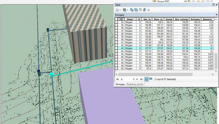
Figure 1 – the formation of attributive tables
Creation of attributive tables (Fig. 1), based on the analysis of available information, helps to fully and quickly collect all available information about underground communications, which are completely different and can be found in different sources. A study of the mechanisms of three-dimensional visualization (Fig. 2) led to a certain three-dimensional visualization.
Displays sewerage, water supply and power lines they have their own attributes and description. If it is a water pipe, the pipes have different diameters and material, all wells are also described in sufficient detail (the marks of the bottom of the well, the top of the pipe (water pipe), the top of the well, other).
Figure 2 – Research of mechanisms of three-dimensional visualization
(animation: 5 frames, 134 kilobytes)
If this is a sewage system, then the mark of the top of the well and the tray (bottom) are indicated. Also, when you display these communications, you need to check that they are displayed according to the rules (rules), for example, when crossing the sewerage and water supply, the sewage system must flow under the water pipe.
In addition to the existing communications, it is necessary to take into account and display underground electrical cables and telephone cables (depth 70-80 cm from the surface), gas pipelines and heating mains (both surface and underground) to visualize the underground infrastructure and collect available information about these facilities.
Conclusion
Further consideration in the work of various approaches and methods of developing 3D visualization technology will allow to analyze and reveal the main characteristics of the three-dimensional mapping of objects. And also to develop scientific and methodological approaches for the creation of three-dimensional land information, on which further development of scientific research will be based.
At the time of writing this abstract, the master's work does not yet have a completed status. The final completion is planned for July 2018. The full text of the work and materials on the topic can be obtained from the author or his supervisor after the indicated date.
References
- К.Ф. Байрактар Трехмерный кадастр недвижимости в России // Программные продукты, системы и алгоритмы. 2015. №2. С. 1-4.
- О.И. Малыгина Трехмерный кадастр основа развития современного мегаполиса. [Электронный ресурс]; Режим доступа: https://cyberleninka.ru/article/v/trehmernyy-kadastr-osnova-razvitiya-sovremennogo-megapolisa.
- Н.А. Николаев, А.В. Чернов Трехмерный кадастр недвижимости как новая ступень развития кадастровых систем. [Электронный ресурс]; Режим доступа: https://cyberleninka.ru/article/v/trehmernyy-kadastr-nedvizhimosti-kak-novaya-stupen-razvitiya-kadastrovyh-sistem.
- Г.А. Стеклова, В.С. Федотова Направления использования ГИС-технологий в землеустройстве и земельном кадастре. [Электронный ресурс]; Режим доступа: https://cyberleninka.ru/article/v/napravleniya-ispolzovaniya-gis-tehnologiy-v-zemleustroystve-i-zemelnom-kadastre.
- Середович, В.А. С32 Геоинформационные системы (назначение, функции, классификация) [Текст] : монография / В.А. Середовия, В.Н. Клюшниченко, Н.В. Тимофеева. – Новосибирск : СГГА, 2008. – 192 с.
- Кулибекова Р.Д.
Земельные информационные системы
(курс лекций) – Махачкала, 2012. – 76 с. - Jacynthe POULIOT, Frederic HUBERT, Canada, Chen WANG, China Claire ELLUL, UK and Abbas RAJABIFARD, Australia 3D Cadastre Visualization: Recent Progress and Future Directions. [Электронный ресурс]; Режим доступа: http://www.gdmc.nl/3DCadastres/literature/3Dcad_2016_28.pdf.
- В.А. Попов, И.В. Ильиных, А.В. Забекин, А.М. Олейник. Разработка и применение 3D модели территории для принятия оптимальных управленческих решений. // [Электронный ресурс]; Режим доступа: https://cyberleninka.ru/article/n/razrabotka-i-primenenie-3d-modeli-territorii-dlya-prinyatiya-optimalnyh-upravlencheskih-resheniy.
- Гаврюшина Н.В. Аналитический обзор систем 3D-кадастра недвижимости. [Электронный ресурс]; Режим доступа: https://cyberleninka.ru/article/v/analiticheskiy-obzor-sistem-3d-kadastra-nedvizhimosti .
- Шепелева А.В., Алиев Т.А., Заболотская Т.А. Трехмерный кадастр недвижимости и развитие современных городских территорий. [Электронный ресурс]; Режим доступа: https://pure.spbu.ru/ru/publications/-------(a1525c83-b8c2-4cab-818c-c21a38171dd7).html.
- Гермонова Е.А., Митрофанова Е.И. – Методологические основы построения 3D-кадастра недвижимости. [Электронный ресурс]; Режим доступа: http://ea.donntu.ru:8080/jspui/bitstream/123456789/10850/1/Mitrofanova.pdf.
- Колчина Н.В., Зюзева М.Ю. Применение 3D технологий для учета объектов недвижимости. [Электронный ресурс]; Режим доступа: http://eledition.ru/magazine/innovation/201605/15-24.pdf.
- Н.В. Шайман Анализ видов 3D кадастра. [Электронный ресурс]; Режим доступа: https://elibrary.ru/item.asp?id=26101058.
- Чернов А.В. Трехмерный кадастр – основной вектор развития успешной кадастровой системы. [Электронный ресурс]; Режим доступа: https://cyberleninka.ru/article/v/trehmernyy-kadastr-osnovnoy-vektor-razvitiya-uspeshnoy-kadastrovoy-sistemy.
- В.Л. Беляев, В.М. Романов Опыт и перспективы применения 3D кадастра при управлении градостроительным развитием подземного пространства. [Электронный ресурс]; Режим доступа: https://cyberleninka.ru/article/n/opyt-i-perspektivy-primeneniya-3d-kadastra-pri-upravlenii-gradostroitelnym-razvitiem-podzemnogo-prostranstva.
- Алексеев Ю.В., Беляев В.Л. Подземные здания и сооружения как системный элемент взаимодействующих пространственных сред развития городской территории // Вестник МГСУ. 2012. №2. С. 6-10.