
Abstract
Contents
- Introduction
- 1. Theme urgency
- 2. Goal and tasks of the research
- 3. Оreview of existing algorithms
- 3.1 Overview of Weather Prediction Methods
- 3.2 Overview of Path Algorithms
- 4. Development of an algorithm for the functioning of the system
- Conclusion
- References
Introduction
Currently, any process of physical or mental activity seeks to computerize. This leads to the emergence of a huge number of computing systems that have to process a large amount of information every second in real time. Embedded computer systems are found in almost any device from watches to space shuttles. Their size, technical application, cost, as well as computing capabilities vary significantly. One of the most promising areas of automation is the transport industry [1]. This is due to the need to exclude the subjective human factor in the participation of road traffic.
1. Theme urgency
The number of vehicles is constantly growing. The problems associated with route compilation, traffic analysis, and increased security are becoming relevant. The widespread use of smart
environments in the transport industry is considered mainly within the framework of the concept of intelligent transportation systems
(ITS) [2]. Intelligent transport systems cannot eliminate all road safety threats. However, they can warn the driver about certain threats. Knowing that there is a dangerous section of the path, you can go around it on a different route.
Modern navigation systems not only build a route, but also take into account traffic jams, speed limits, repair of road sections and other parameters that affect the choice of route. Properly planned route and automation of management will save fuel costs, respectively, and reduce environmental damage, minimize accidents and catastrophes [3]. Many transport systems already have built-in navigators, the task of which is to build a route from point A to point B. For this, various algorithms are used that are actively used in laying networks, wiring printed circuit boards, moving objects in computer games. But these algorithms do not take into account weather conditions, which can have a big impact on traffic safety. The problem of intellectualization of transport systems using publicly available equipment remains relevant, which will make it possible to lay a route, taking into account weather conditions in real and future time, with acceptable speed of choosing a rational route.
2. Goal and tasks of the research
The aim of the study is to develop a weather forecasting system on road sections to improve the safety of vehicles.
The main objectives of the study:
- Analysis of short-term weather forecasting methods;
- The choice of methods to make a forecast based on limited weather data;
- Analysis of methods for constructing a route on a road graph;
- Construction of routes on a map taking into account current and forecasted weather conditions.
Object of study: building routes according to the weather.
Subject of study: combining short-term weather forecasting methods with an algorithm for constructing a route on a map.
As part of the master's work, it is planned to obtain relevant scientific results in the following areas:
- The development of an algorithm for short-term weather forecasting, followed by the determination of dangerous sections of road primitives at a specific point in time, based on well-known weather forecasting methods;
- Determining the best algorithm for constructing a path on weighted road graphs;
- Combining weather forecasting algorithms and building paths to find a safe route on a map.
For an experimental assessment of the theoretical results obtained and the formation of the foundation for subsequent research, it is planned as practical results development of a system for finding optimal paths with the following properties:
- Collection and storage of weather data (temperature, humidity and atmospheric pressure) on the road primitive;
- Determination of the hazard category of vehicles in the area of the weather forecasting system;
- Drawing a road graph in the form of a map of the investigated road section;
- The ability to select the starting and ending points of the path for vehicles;
- Building from one to 3 optimal routes, depending on the weather forecast.
3. Оreview of existing algorithms
Since ancient times, people have tried to predict the weather, observing patterns in any events. Weather forecast occupied an important place in the life of society of different nations with the advent of the first civilizations. But at that time, the forecast was associated with visible natural phenomena, the behavior of animals, which was expressed in folk signs. And only the invention of the first meteorological instruments in the 17th century laid the foundation for instrumental observations, the formalization of which was mainly carried out by foreign researchers. Algorithms for constructing the path have been dealt with by various scientists since the mid-20th century. Currently, both foreign and domestic researchers are involved in navigation problems and the safety of transport systems.
3.1 Overview of Weather Prediction Methods
Prediction of weather by a barometer began in the 17th century, but the algorithm was described by Negretti and Zambra only in 1920. [4]. The company introduced the Zambretti weather calculator, which is a compact device consisting of circles (disks), on the back of which there was a forecast. The circles took into account the direction of the wind, atmospheric pressure (AP), its dynamics of change and season.
Later, Raymond M. Siger described in more detail the forecasting algorithm, which additionally took into account cloudiness in making the forecast (pic. 1).
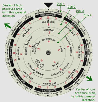
Picture 1 — The Sager Weathercaster Weather Calculator
The calculator has 4 discs:
- Considers wind direction and change;
- Indicates atmospheric pressure (in inches of mercury);
- Shows the rate of change of AP (invariably, quickly / slowly drops / rises);
- It takes into account cloud cover (clear, light cloud cover, mostly cloudy, cloudy, rain).
Having set the data of all 4 disks along the black triangle, a digital code is obtained. The decoding is described in a special reference [5].
The considered algorithms do not take into account air temperature. Observing the patterns of changes in air temperature during the day, the likelihood of night frosts was deduced. Graphically, this dependence was deduced by Professor Brounov (pic. 2) [6]:
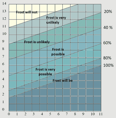
Picture 2 — Chart of the probability of night frost
The vertical axis indicates the air temperature at 21:00, and the horizontal axis shows the temperature difference at 13:00 and 21:00. It is only necessary to determine at what point the intersection of these two parameters lies.
For longer forecasts, mathematical algorithms are used. They allow you to make a forecast for a long time and require huge computational costs. As a rule, they are calculated on supercomputers and take into account more initial parameters. For the task at hand, the accuracy of the predictions of the considered simple algorithms is quite enough.
3.2 Overview of Path Algorithms
The road network along which it is necessary to build a route is presented in the form of a weighted graph (pic. 3), which is stored in matrix form. The vertices of the graph are segments of the road network, and the connections show the connections between these segments and the cost
of the transition from one to another. The transition cost is determined by the geometric length of the segment and the average speed of the object along the segment [7]. Thus, the weighted graph of the road network is set in the form of a square matrix, the size of which is determined by the number of vertices of the graph.
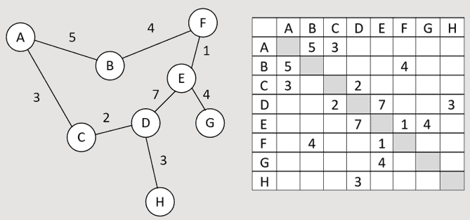
Picture 3 — The simplest road graph and its matrix representation
The most popular algorithms for finding a path in a weighted graph [8]:
- Dijkstra;
- Bellman–Ford;
- А*;
- Lee (wave algorithm).
Dijkstra's algorithm (pic. 4) is the most famous and widespread algorithm. Works exclusively for graphs with positive weight edges. This algorithm is considered one of the simplest. It performs well in graphs with few vertices. In the case of a network of roads, the number of peaks in a graph can reach several thousand. Then the use of this algorithm will not be the optimal choice for solving the problem.
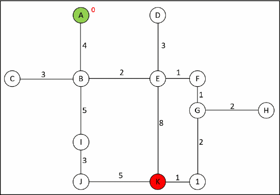
Picture 4 — Finding a path on a graph using Dijkstra's algorithm
(animation: 9 frames, 5 cycles of repetition, 85 kilobytes)
The Bellman-Ford algorithm, unlike the Dijkstra algorithm, admits the presence of edges with negative weight in the graph. This algorithm finds the shortest paths from one vertex of the graph to all the others and uses complete enumeration of all vertices of the graph, which will lead to a big loss of time.
Algorithm A * is essentially an extension of Dijkstra's algorithm, but achieves higher performance due to the introduction of the heuristic function algorithm. A typical heuristic formula is expressed as [9]:
f(n)=g(n)+h(n), (1)
where f(n) — score value assigned to node n,
g(n) — lowest cost of arrival at node n from the start point,
h(n) — heuristic approximation of the cost of the path to the goal from node n.
This algorithm step by step looks through all the paths leading from the initial vertex to the final one until it finds the minimum one.
The Lee algorithm is mainly used for computer wiring of printed circuit boards, connecting conductors on the surface of microcircuits. For working with weighted graphs, this algorithm is not the most efficient algorithm.
Google hides an algorithm that it uses as the main one for working in its service. Unlike him, Yandex in the public domain not only indicates that it uses the Dijkstra algorithm, but also describes its operation [10]. Among the considered algorithms, one of the most popular for navigation systems is the Dijkstra algorithm
4. Development of an algorithm for the functioning of the system
Based on the tasks set, the developed system should solve such problems as collecting meteorological data, transferring them to an information storage and processing device, a short-term forecast of weather conditions, building a route taking into account weather conditions. Thus, the system consists of a certain number of devices for collecting and transmitting weather conditions, which are associated with a single service for storing and processing information (pic. 5).
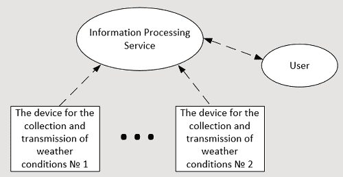
Picture 5 — The structure of the system
The device for collecting and transmitting weather conditions consists of:
- sensors: temperature and humidity, atmospheric pressure;
- devices for processing and storage of weather conditions;
- data transfer module into a single information processing service.
A single information processing service is a server on which data from all devices for collecting and transmitting weather conditions will be stored. Also, this service will process the received data and update it for the map on which the route will be laid. As a weather forecasting algorithm, both Zambretti
and Brounov algorithm will be used simultaneously. The second will be taken into account only when forecasting night frosts. To build a route, the Dijkstra algorithm is used.
As a result of the work, the user should receive a map with the possibility of choosing a path showing what weather conditions are waiting for him on the road along a particular route (pic. 6).
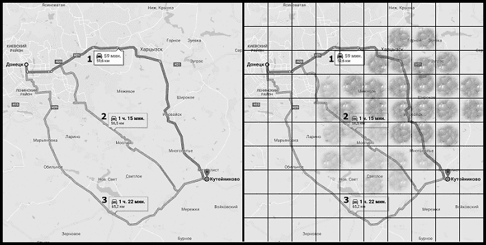
Picture 6 — Building a route on a Google maps
The figure on the right shows an example of the imposition of known weather parameters. Each cell represents the area of a separate weather data collection device. Brighter circles in the cell indicate adverse weather conditions. Transparent circles indicate predicted adverse conditions. The lack of circles symbolizes good weather conditions that persist in the near future. Thus, the standard algorithm used in the maps will choose the path at number 1, since it is the fastest. But considering that on the way 1 there will be bad weather conditions, it is better to choose 2 or 3. At the same time, you need to consider how long the vehicle will overcome the zone of possible adverse weather conditions. In the case when the path takes more than a few hours, it is rational to immediately choose the path number 3.
Conclusion
In the course of the review of the existing path finding systems on the map, it was determined that they do not use weather data. Analysis of existing algorithms for short-term weather forecasting showed that for high-quality forecasting, it is necessary to know the data on the direction and speed of the wind. In this regard, there remains the problem of a qualitative forecast using a minimum number of sensors. To build a route, there are many algorithms, among which there are systems that satisfy the requirements (Dijkstra, A*), which allows them to be used in the developed system. In the future, it is planned to implement a software model of the system and improve weather forecasting algorithms.
References
- Кравченко М.К. Разработка структуры системы мониторинга и анализа изменений метеоусловий / М.К. Кравченко, Д.В. Николаенко // 69–я Международная студенческая научно–техническая конференция, Астрахань, 15–19 апреля 2019 года [Электронный ресурс]: материалы / Астрахан. гос. техн. ун–т. — Астрахань: Изд–во АГТУ, 2019.
- Николаева Р.В., Газизова З.С., Загидулина А.Д. Формирование и развитие интеллектуальных транспортных систем // Техника и технология транспорта. Выпуск № 1(1) – Казань, КГАСУ, 2016. С. 8-14.
- Кривошеев С.В. Исследование эффективности параллельных архитектур вычислительных систем для расчета параметров движения транспортного средства // Научные труды Донецкого национального технического университета. Выпуск № 1(10)-2(11). Серия «Проблемы моделирования и автоматизации проектирования». – Донецк, ДонНТУ, 2012. С. 207-214.
- Монатко Д. Погодный калькулятор Zambretti [Электронный ресурс] // Monatkodenis: [сайт] 2016. URL: http://monatkodenis...
- Raymond M. Sager. A scientific instrument for accurate prediction of the weather
The Sager weathercaster
// Published 1969 by Distributed by October House in New York. URL: https://openlibrary... - Гринченко Н.Н., Потапова В.Ю., Тарасов А.С. Алгоритмы прогнозирования погодных условий в системах сбора и обработки метеорологических данных // Известия Тульского государственного университета. Технические науки, 2018, Вып. 2. — С. 113–119 // URL: https://cyberleninka.ru/article...
- Дорогов А.Ю., Лесных В.Ю., Раков И.В., Титов Г.С. Алгоритмы оптимального движения мобильных объектов по пересеченной местности и транспортной сети // Санкт-Петербургский государственный электротехнический университет, 2008, № 3. — С. 419–427 // URL: http://dspace.nbuv.gov...
- Изотова Т.Ю., Обзор алгоритмов поиска кратчайшего пути в графе // Новые информационные технологии в автоматизированных системах. 2016. С. 341–344.
- Bryan Stout. The Basics of A* for Path Planning. In Game Programming Gems. // Charles River Media, 2000. PP. 254–263.
- Маршрутизация [электронный источник] // ООО «Яндекс»: [сайт]. 1997-2019. URL: https://yandex.ru...