DonNTU |
Master's portal |
Resume
| References
| Library
| Report about searching for
| Individual task


Zholner Alexander
Faculty: Mining-Geolodgical
Theme of master's work:
«The system engineering of graphic display showing to deformation of a terrestrial surface in earned additionally territories»
Leader of work: doctor of technical science Grischenkov Nikolay Nikolayevich .
Materials on the theme of master's work:
Email: zholneraleksandr@rambler.ru
Abstract
Urgency
As it is known, underground mining of mineral deposits is accompanied subsidence rocks, that in most cases leads to subsidence of a terrestrial surface and its deformation. Depending on technology and a way of vision of mountain works, speed promovings, capacities of a layer, depth of conducting works, etc., subsidence of a terrestrial surface can already occur during conducting mountain works, or after their end, and can proceed in a current of several tens years. It is necessary to notice, that influence of dredging of coal on a condition of a terrestrial surface is observed even at depth of working out of 1000 and more metres.
As at conducting mountain works there is a working out of stocks being under the built up territories, there is a necessity for acceptance of measures of protection for maintenance of safe operation of earned additionally buildings, constructions, natural objects, etc. For this purpose it is necessary to define a zone of influence of mountain works on a terrestrial surface, that is to execute construction contour subsidence. The given constructions will allow to represent visually a zone of a terrestrial surface with buildings being on it and the constructions, got to a zone ïîäđàáị̂êè at conducting mountain works.
The work purpose
To develop system which will allow to carry out graphic construction of deformation of a terrestrial surface with drawing in respect of a lava, or of some lavas, a contour subsidence, horizontals of a surface, subsidence isolines, and as all buildings located on a terrestrial surface, constructions and other objects getting to a zone underworkings.
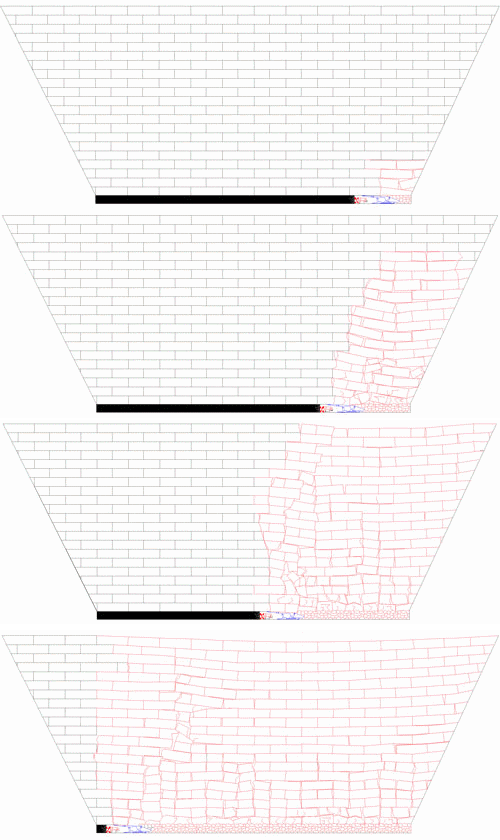
 Animation - 1. Influence deformation rocks on surface subsidence.
Problems:
1. working out of the program in the environment of VBA (Visual Basic Application), allowing to use data of calculations of parametres movings other programs brought in an electronic database, text file, for their graphic representation.
2. numbering objects of a surface: to develop system with which help to make shooting of co-ordinates of buildings, constructions and other objects from existing paper carriers (plans of mountain works), or brought in an electronic database and their automatic construction in the graphic program (Auto CAD)
3. numbering lavas: the system engineering, similar previous for a graphic representation of settlement lavas, and also systems allowing to represent a contour concerning the given lavas.
4. to develop the program for automatic construction of horizontals of a surface subsidence boundaries character and subsidence size.
5. to co-ordinate all existing and developed programs in one system which will allow to carry out automatic construction of all elements – lavas, subsidence boundaries in the plan, objects of a surface, horizontals of a surface, subsidence isolines.
Scientific novelty and practical result
Now existing programs of calculation of deformation of a hills and subsidence of the terrestrial surface, allowing to carry out calculation of all necessary parametres shift rocks, at undermining hills, are not capable to execute graphic constructions of deformations of a terrestrial surface, for the evident image of deformation of a surface and the buildings located on it, constructions and other objects.
For today corresponding graphic representations of deformation of a surface are carried out manually, or by means of a number of the programs, the received which results as are subject to processing that is enough labour-intensive process. Thus the system engineering, allowing automatically to carry out graphic construction of deformation of a terrestrial surface with the image of objects of a surface, a contour subsidence, horizontals of a surface and subsidence isolines, will allow to automate graphic constructions and to reduce to a minimum spent time for performance of similar works.
DonNTU |
Master's portal | Autobiographi
| References
| Library
| Report about searching for
| Individual task

