
|

Kiyashko Ekaterina
Institute of Mining and Geology
Speciality: Surveying and cadastre
Theme of master's work: «Research and analysis of cadastre information in databases»
Scientific adviser: professor, Doctor of Engineering Science Sholomitskij Andrey Arkadievich
About author
Summary of research and developments
Object of work:
Exchange files of cadastre information (4000 exchange files of Donetsk).
Tasks:
1) research and analysis of semantic information of exchange files;
2) research and analysis of metrical (spatial) information of exchange files;
3) creation of DB by the use of modern GIS, for the collection, processing, storage, and also visualization of cadastre information.
Actuality
Nowadays it is impossible to present an effective management resources without the use of computer technologies, because in the process of collection and treatment of cadastre information it is necessary to take into account plenty of properties of different objects and their indexes, and also their intercommunications. An actual task is systematization and organisation of processes of collection, storage and treatment for making the decisions in relation to cadastral objects. For the decision of these questions automatized system of collection and processing of cadastral information is developed.
In accordance with the resolution of Cabinet of Ministers of Ukraine ą1355 «About the program of creation of automatized system for conducting of state land cadastre» Dec. 2, 1997, automatized system is the united state system for the providing authorities, citizens, enterprises, establishments and organizations with reliable information about land.
In accordance with the Order of Land Authority of Ukraine ą136 «About the claim of requirements to the structure, maintenance and format of exchange file by the information of surveying works' results on the magnetic transmitters».
An exchange file is an unified structure of the land cadastral data, which contains the results of the executed surveying works, in kind of electronic.
The structure of exchange file is presented on Picture 1.
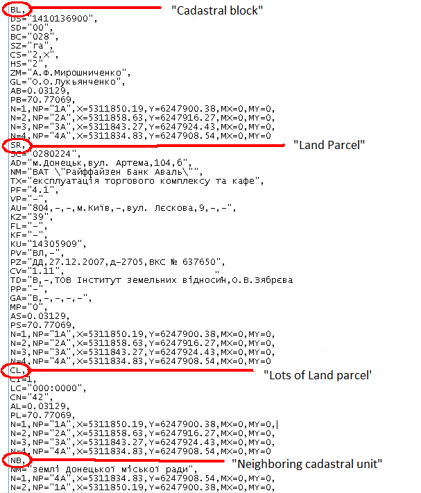
Picture 1 - The structure of exchange file .in4.
An exchange file is intended for standardization of land cadastral information about land parcel or their totality in a kind of electronic. An exchange file contains: metrical, semantic and official information. Land cadastral information of exchange file must answer information contained in a surveying documentation.
An exchange file consists of structural land cadastral data blocks:
- «Cadastral block»
- «Land parcel»
- «Lots of land parcel»
- «Cadastral area»
- «Neighboring cadastral unit»
Every structural land cadastral data block contains of lines with the fixed amount of the structural fields of metrical information (rectangular co-ordinates are in the Gaussa-Kryugera's projection) and semantic (attributive) information of cadastral unit. Every line (teg) begins with a keyword (descriptor).
An exchange file also contains information about:
- information of exchange file;
- information about persons, which formed, carried out a check (editing) of exchange file.
Informative part is used for an exchange information about land cadastral units, territorial areas and their metrical information. Informative part consists of such elements as:
- metrical information of exchange file;
- territorial area;
- cadastral area;
- subjects of the land relations;
- rights on the land parcels;
- restrictions of the land use;
- land lots.
An exchange file is created as a XML file in a kind of text strings, which contain elements and attributes, and also their values. The names of elements and attributes are formed from English letters. The structure of exchange file consists of two parts: official and informative
Chart 1 - The structure of exchange file (Animation made in the program gif_animator, contains 8 frames, size of the animation is 58.4 kB)
Additional Part is used for forming and exchange information about the properties of exchange file and performer of works.
Informative part is used for an exchange information about land cadastral units, territorial areas and their metrical information.
Cadastral area consists of cadastral areas, which then are subdivided into parcels.
In this work research and analysis of cadastral information is executed in accordance with the Order of Land Authority of Ukraine ą136, because the new structure of exchange file is not yet inculcated in the Survey Authority
The module of automatic verification of In4 was used for research of semantic information of exchange files. This module is a part of software for a digital cartography and survey organization of Digitals.
As a result of research of 4000 exchange files, there was exposed the appearance of 49 errors among the 65 possible errors.
The most widespread (meets in 75% exchange files (from 4000)) is an error 104 (Descriptor of AU). This error is related to the wrong filling of AU line, which contains lists about the address of land owner's (user's) registration. The AU line consists of 9 fields contained:
1) Country code in accordance with Classifier of the world countries of DK007-96;
2) Post index;
3) Name of autonomous republic, city of state value, area;
4) Name of district’s area;
5) Name of settlement (city);
6) Type and name of street (passage);
7) Number of house;
8) Number of building;
9) Number of flat
Very often in the fields 3 and 4 are wrote down the name of settlement, that results the appearance of this error.
The module of verification of In4 executes verification in accordance of values of associate descriptors. For example, descriptors CV (code of the having a special purpose use of area) and CN (the lot’s code) link between itself. At the defined values of CV, CN can not take on all legitimate values. For example, a value Cn="14"(under household buildings and yards) does not comport with a value Cv="1.1"(for an agricultural production). This error meets in 28% exchange files.
An error of disparity of amount of the fields in lines is also widespread.
The listed errors exist because of hand-made method of exchange files' creation, the majority of exchange files is formed in the text editor "WorPad"
The use of SABD PostgreSQL is assumed for the analysis of spatial information, namely spatial relation of objects, crossing, imposition e.c., and also storages of information.
There is a possibility to save maps in program Digitals and to spatial data in the PostgreSQL.
PostgreSQL - is freely expandable object's relation controls database system (ORDBMS). It is the most developed open SABD in the world and it is also the alternative commercial data base. The use of PostGIS is assumed for the research and analysis of spatial information of exchange files.
PostGIS – is the broadened object's relation SABD of PostgreSQL. It is intended for storage in the base of geographical information.
Some functions of geometrical connection in PostGIS:
-ST_Intersects(geometry, geometry)
Returns 1 (TRUE), if the geometry “spatially intersect”
-ST_Touches(geometry, geometry)
Returns 1 (TRUE), if the geometry “spatially adjoin”
-ST_Within(geometry A, geometry B)
Returns 1 (TRUE), if the geometry A is “spatially inside” geometry B
-ST_Overlaps(geometry, geometry)
Returns 1 (TRUE), if the geometry “partly spatially recover”
-ST_Contains(geometry A, geometry B)
Returns 1 (TRUE), if the geometry A “spatially contains” geometry B
-ST_Covers(geometry A, geometry B)
Returns 1 (TRUE), if any point of the geometry B is out of geometry of A.
This article is written before the master's work is completed. Completion of work is planned by the end of 2010. More detailed information about final results can be got from the author of work
Literature
- Ďîńňŕíîâëĺíčĺě ĘĚÓ ą1355 «Î ďđîăđŕěěĺ ńîçäŕíč˙ ŕâňîěŕňčçčđîâŕííîé ńčńňĺěű âĺäĺíč˙ ăîńóäŕđńňâĺííîăî çĺěĺëüíîăî ęŕäŕńňđŕ» îň 2.12.1997ă. [ýëĺęňđîííűé đĺńóđń]http://zakon1.rada.gov.ua/cgi-bin/laws/main.cgi?nreg=1355-97-%EF
- Ďđčęŕç Ăîńęîěçĺěŕ Óęđŕčíű ą136 îň 23.05.03đ «Îá óňâĺđćäĺíčč ňđĺáîâŕíčé ę ńňđóęňóđĺ, ńîäĺđćŕíčţ č ôîđěŕňó ôŕéëŕ îáěĺíŕ äŕííűěč đĺçóëüňŕňîâ çĺěëĺóńňđîčňĺëüíűő đŕáîň â ýëĺęňđîííîě âčäĺ íŕ ěŕăíčňíűő íîńčňĺ ë˙ő.»
- Ďđčęŕç Ăîńęîěçĺěŕ Óęđŕčíű ą573 îň 02.11.09đ «Îá óňâĺđćäĺíčč ňđĺáîâŕíčé ę ńňđóęňóđĺ, ńîäĺđćŕíčţ č ôîđěŕňó îôîđěëĺíč˙ đĺçóëüňŕňîâ đŕáîň ďî çĺěëĺóńňđîéńňâó â ýëĺęňđîííîě âčäĺ (îáěĺííîăî ôŕéëŕ).»[ýëĺęňđîííűé đĺńóđń]http://zakon1.rada.gov.ua/cgi-bin/laws/main.cgi?nreg=z0157-10
- www.vingeo.com - ĂĹÎŃČŃŇĹĚŔ - íŕó÷íî ďđîčçâîäńňâĺííîĺ ďđĺäďđč˙ňčĺ.[ýëĺęňđîííűé đĺńóđń]http://www.vingeo.com/Rus/index.html
- Ěĺńňî PostGIS/PostgreSQL ńđĺäč ŃÓÁÄ ń ďîääĺđćęîé ďđîńňđŕíńňâĺííűő äŕííűő, ďî äŕííűě GIS-LAB - Ăĺîăđŕôč÷ĺńęčĺ číôîđěŕöčîííűĺ ńčńňĺěű č äčńňŕíöčîííîĺ çîíäčđîâŕíčĺ.[ýëĺęňđîííűé đĺńóđń]http://gis-lab.info/qa/postgis-compare.html
About author | Master's portal of DonNTU