Introduction
This article presents the cadastral system and the role of the private licensed surveyors in Denmark as a consideration for its relevance to the ongoing discussion in Ireland. Denmark and Ireland are comparable in many aspects. The countries are almost the same size in terms of area and population and the urban pattern as well as the rural land use is also equivalent. But the cadastral systems are quite different. Where the Irish system follows the UK model based on general boundaries and a land registry title system, the Danish system is based on fixed boundaries to identify the real properties in the cadastral system as a basis for entering the titles at the Land Registry at the local district courts. The cadastral register and the cadastral maps are maintained by the National Survey and Cadastre while the legal survey measurements and the boundary determinations are carried out by private licensed surveyors.
The very heart of the Danish system is the interaction between the private licensed surveyors and the National Survey and Cadastre for maintaining the Digital Cadastral Data Base. This also relates to the increasing demand for improving the accuracy of the cadastral information as a basic layer for building the Geospatial Data Infrastructure of the future.
The Danish Cadastral System
The Danish cadastre, which derived from the results of the enclosure movement, was established in the year 1844. From the beginning the cadastre consisted of two parts; the cadastral register and the cadastral maps. Both of these components have been updated continually ever since.
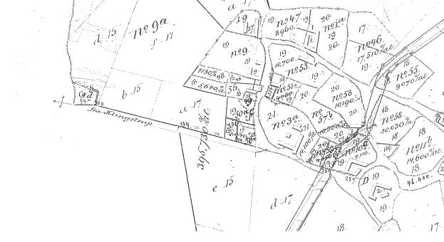
As a result of the enclosure movement, the former feudalistic society was changed into a society based on private ownership to land. The necessary maps were surveyed by plane table at a scale of 1:4,000. The resulting property framework from the enclosure movement formed the basis for the new cadastral maps. Each map normally includes a village and the associated cultivated areas. As a result the maps are "island maps" covering different areas and not based on any local or national control network. The boundaries of the urban parcels in the villages were shown very approximately on the cadastral maps since these urban properties were not important for land valuation purposes. The provincial towns were surveyed separately based on a provision from 1863. The maps are established by traversed surveys, most of them in the scale of 1:800.
The parcels within each village area were numbered and recorded in the cadastral register showing parcel areas, parcel numbers , and the valuation of each property (being an aggregation of several parcels in the property) with the cadastral maps showing the location of the cadastral parcels. The present cadastral system is still based on these historic village areas which constitute the framework for the register and the cadastral maps.
Even if the primary purpose of the cadastre was to levy land taxes, the cadastral
identification was also used to support the land ownership and land transfer system. Even
though the cadastre was established in 1844, and it has been a requirement since 1810 that
all subdivisions of land and all changes of boundaries had to be undertaken by private
licensed surveyors. Simultaneously, in 1845, a Land Registry was established by the local
district courts for recording and protecting legal rights of ownership, mortgage, easements
and leases for land. The Cadastral System was then established as follows:
- The cadastral register identifies real properties - which might include more than one
land parcel - by cadastral number(s) and area,
- the cadastral map shows all land parcels graphically,
- the legal survey measurements are used to precisely identify all new parcel
boundaries determined by cadastral surveys such as subdivision etc.,
- the Land Book identifies the legal rights based on the cadastral identification.
The cadastre is maintained by the National Survey and Cadastre while the cadastral surveys are carried out by the private licensed surveyors. Over time the Danish cadastre has changed from being a basis for land valuation to a legal cadastre supporting the land market.
The Computerised Cadastral System
The cadastral register was computerised during the period 1984-86. The register includes 2.5 mill parcels representing about 1.5 mill properties. The computerisation of the cadastral maps was completed by the end of 1997. The computerisation of the Land Book was completed in 1999.
The basic function of the cadastral map will still be the same even if the maps are computerised. The benefits will be multipurpose use of the maps, in combination with other land data registers and maps, leading towards cadastral based GIS-systems. The concept of a modern digital cadastre therefore has to face the challenge of being an effective tool for the cadastral process of subdivision and land transfer, as well as being an efficient tool for land management and administration. The challenge will be to use the lowest acceptable standard for fulfilling these objectives in order to minimise the costs of computerisation.
The multipurpose use of the map requires in principle consistency with the topographic map. The demand for consistency refers to topographic maps at a scale of 1:1,000 in urban areas and 1:4,000 in rural areas. On the other hand, the historic legal identification of the boundaries must be kept intact even if the maps are computerised for multipurpose uses. The analogue cadastral maps are island maps which are not related to the national grid. Over time they have become distorted due to shrinkage, redrawing and updating procedures. Just digitising the analogue maps will not result in a multipurpose map.
GeoMedia є прообразом першої версії міжнародних стандартів в галузі ГІС, що розроблюються Open Geospatial Consortium (OGC) і, одночасно, є першою реалізацією цих стандартів.
Recognising these problems, and accepting that the cost of computerisation of the cadastral
maps must be reasonable, this computerisation process is undertaken in two stages:
- State control points and cadastral surveys connected to the national grid form a
“skeleton” cadastral map. In urban areas about 40 % of the boundary points are
entered this way and in rural areas about 20 %.
- The remaining parcels areas are inserted in the map by digitising the analogue
cadastral map and fitting in these to "skeleton map" by transformation. Identified
elements in the digital map are also used to control the transformation of the
analogue map.
By using this approach the accuracy of the boundary coordinates may vary considerably, ranging from a few centimetres in some urban areas to several metres in some rural areas. Therefore, the digital cadastral may not totally compare to a digital topographic map. However, it must be considered that the nature and origin of those two kinds of maps are fundamentally different. It must be considered that the nature and origin of those two kinds of maps are fundamentally different.
It must also be noted that the digital cadastral map is a graphic map, not a numeric map. This means, that the coordinates for the boundary points only represent the boundary in the graphic map. The final determination of boundaries must be done according to the cadastral regulations. The parcel coordinates in the DCDB therefore may not be used for exact calculation of parcel areas and dimensions.
The procedures for updating the digital cadastral map or DCDB will be just opposite to the procedure for updating the analogue map. In the analogue map new boundaries were adjusted graphically to the position of existing mapped boundaries. In the digital cadastral map any new cadastral measurement will be used for adjusting the position of the existing boundaries. This will establish a process of continual improvement of the accuracy of the DCDB, - a dynamic element. It is however recognised that some problems may arise in practice when a decision has to be made on the area to be included in the adjustment. Furthermore, adjustment of existing boundaries in the DCDB may cause problems in those cases where other administrative boundaries or features were based on cadastral boundaries in a Geographical Information System. These problems of upgrading the DCDB will continue to be investigated so that sustainable solutions can be developed to suit all users. A general understanding of these problems related to the process of establishing and maintaining the digital cadastral map are essential for all users. In other words, the success of the digital cadastral map will depend on the degree of educated use of the map.

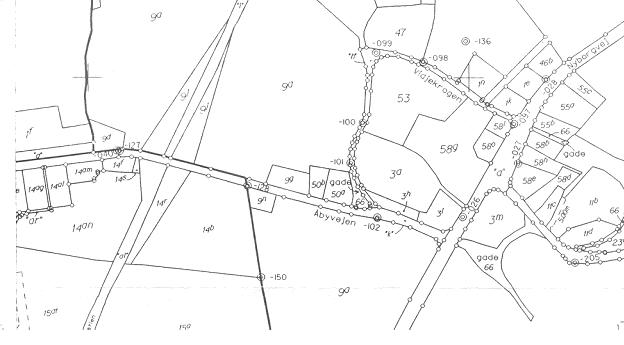
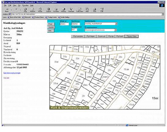
To establish a country-wide digital cadastral map has been a major challenge to the National Survey and Cadastre as well as to the surveying profession. However, the real challenge will be to make this advanced product understandable and useful to a wide range of users. One way of doing this will be to introduce the product on the Internet and make it available just like any other kind of spatial information. Therefore, the cadastral register as well as the digital cadastral map is made available on the Internet by April 1998. Another way of doing it will be to educate the public about a number of applied uses of the digital cadastral map. In fact, this is already taking place. The era of the multipurpose cadastre is just around the corner.
The cadastral process itself will also be improved. A concept for a digital format to be used for the exchange of information between the private licensed surveyors and the National Survey and Cadastre is currently being developed. This will allow for a fully digitised cadastral process which was implemented by 1st of January 1999.
The Process of the Cadastral Work
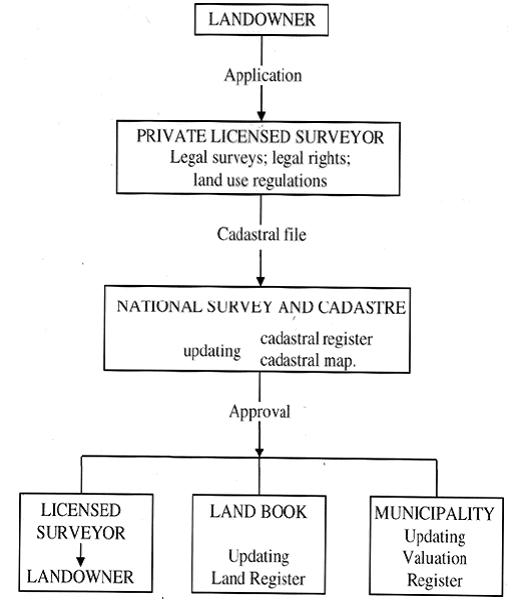
When land is to be subdivided or property boundaries changed, both private and public landowners must apply by law to a private licensed surveyor for the necessary legal surveys and for the preparation of documents needed for submission of an application to the National Survey and Cadastre for updating the cadastre. The application must contain a copy of the cadastral map showing the alteration of the boundaries, measurement sheets showing the new boundaries, documentation for legal rights, as well as documentation showing the approval of the future land use according to planning regulations and the relevant land use laws. The approval from the National Survey and Cadastre, showing the updated cadastral register and the updated cadastral map, is returned to the licensed surveyor. Simultaneously, the approval is forwarded to the municipality for updating of the property tax register, and to the local Land Registry Office for updating the Land Book. Deeds or mortgage may then be entered in to the land book based using the updated cadastral identification. The process of the cadastral work is controlled by the Act of Subdivision and Land Registration providing very detailed regulations.
To determine the existing boundaries the surveyor must compare the legal survey information (the cadastral map and the measurement sheets) to the actual state of conditions, placement of fences etc. If discrepancies are found the surveyor has to clear up the reason. Maybe the land owners have agreed for another boundary without taken care for updating the cadastre or maybe the boundary in the field has been accepted by the landowner for more than 20 years which may lead to the establishment of a prescriptive right. In these cases, the licensed surveyor must involve the landowners, an if they cannot agree on the reason for the discrepancy the problem must be solved through a special legal procedure for boundary determination carried through by the licensed surveyor. Boundaries are surveyed to a high accuracy in a local sense and corners are typically marked with iron pipes. Today most surveys are connected to control points and linked into the national geodetic network (since 1934). Within a few years the demands for a fully digitised cadastral process tends to be mandatory.
The Private Licensed Surveyors
Cadastral work, or surveying for legal purposes, in Denmark is a monopoly of licensed surveyors in private practice. Licenses are granted by the Minister of the Environment after the surveyors have completed a University degree, M.Sc. in Surveying, Planning and Land Management, and after having worked for a private surveying firm for three years. There are about 100 private surveying firms employing about 300 surveyors in total (as per January 2002). The number of surveying firms is decreasing and the structure of the private surveying branch is changing over time. The trend is towards bigger firms and company cooperations.

The duties and responsibilities of the licensed surveyors are controlled through the Surveyors Act. The process of the cadastral work regulated in the Act of Subdivision and Land Registration. When land is to be parcelled out or property boundaries to be changed, the private or public landowner must apply to a private licensed surveyor for the legal surveys and for the preparation of documents needed for submission of an application to the National Survey and Cadastre for updating the cadastre. The application must contain a map showing the cadastral alterations, measurement sheets showing the new boundaries, documentation regarding the legal property rights, and documentation for the future land use in consistency with any planning regulations and relevant land use laws. The approval from the National Survey and Cadastre, showing the updated register and the updated map, is returned to the licensed surveyor, and it is forwarded to the municipality for updating of the property tax register, and to the local land registry office for updating the land book.
The total dataflow in the cadastral process is currently transformed into digital lodgement and processing. Next to cadastral work, the private surveying firms carry out engineering surveys, and mapping tasks, and offers consultancy on legal and managerial issues concerning land use and property rights. In average, the cadastral tasks account for about 40% of the working hours, while mapping accounts 10%, engineering surveys 20% and consultancy activities 30%.
The Profile of the Danish Surveyor
The professional profile of the Danish surveyor is a combination of technical, judicial and design areas. The profile thus is a mix of an engineer, a lawyer and an architect, and the professional fields consist of three areas: surveying and mapping, cadastre and land management, and spatial planning. Cadastral tasks are the monopoly of licensed surveyors in private practice, and the role of this private surveyor has traditionally epitomised the Danish surveyor. About 40% of the Danish surveyors are employed in the private surveying firms, while about 45 % is employed at the state agencies or at regional or local council administration. The rest, about 15% are employed in other private companies such as engineering companies, IT-development firms, and limited companies.
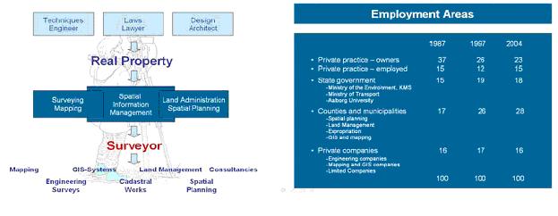
This very broad professional profile seems to appeal to potential students and it allows for a very broad spectre of employment opportunities in both the private and the public sector. The synthesis of the professional traditions in engineering, architecture and law also provides excellent skills for handling interdisciplinary problems.
Final Remarks
This paper does not attempt to argue for or against the system of fixed boundaries as is applied in Denmark and most countries in central Europe. Any cadastral system is unique and mirrors the cultural and administrative development of the jurisdiction.