The main objectives of a GIS project are as follows:
2. STAGES
FOR IMPLEMENTATION AND USING OF A GIS
Mainly, the implementation and exploiting a GIS is developed in the following stages:
Defining the requests. It involves a detailed study of the user’s requirements. After this study there are established the quantitative and qualitative features of the final products (precision, structure, representing scale) and it is estimated the data volume;
Establishing the system functions. Being known the requirements, it is necessary to be specified the functions which must be accomplished by the system for fulfilling its objectives.
Projecting the data base. Into the GIS the data are stocked in thematic layers. It is necessary to be defined these layers and features (attributes) of the data stocked in each of them.
Choosing and procuring the equipments and programs. Among different possibilities for implementing a GIS must be chosen the variant that assures the totality or majority of the functions established as being necessary in conditions of maximum efficiency.
The personalization of the programs at the application requirements.
Loading the
data base. It consists in making the digital map by completing the layer
data.
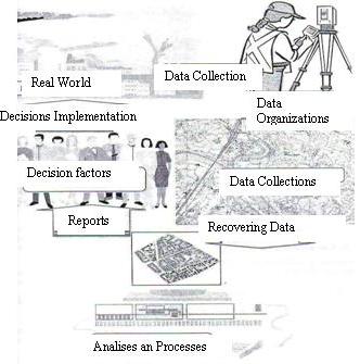
Exploiting
the GIS This is developed in three main directions: updating,
analyze, reports:.
The
digital map must be made by valorizing all the existent resources based
on a good analyze of these content and the involved costs, following
to assure the necessary quality, in conditions of maxim efficiency.
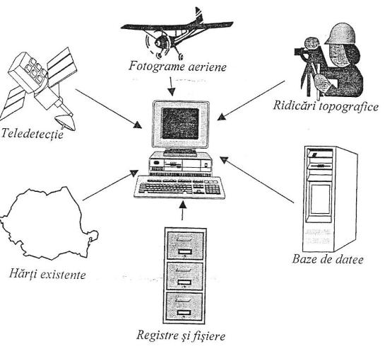
Into the fig. 3.1 it is presented a general scheme of principle of sources
that can be taken into consideration fr making the digital map. Acquisitioning
the data is the process of conversion of the data for the shape
in which it is exists in one that can be used by a GIS. In
order that the spatial data can be obtained from a great variety of
sources, it must be done the difference between acquisitioning new data
and of the existent one. The
GIS technology is used in all fields for which the spatial information
is relevant, so the fields that use the geographic map for stocking,
analyze and representing. No matter what is the field, any GIS application includes a spatial data
base (digital map) and a program (soft) that exploit these data base. The
digital map must contain the spatial data specific to the field of the
application. In order to furnish the useful information, the data base
must be actual, that means to represent correctly the terrain (geographic
space) which is continuously in changing. The
soft contains many analyze functions of spatial data contained into
the digital map and of visualizing the resulted information, specific
to the application field. After
the exploitation of the underground and opens casts substances there
are formed holes called exploitive areas. If the exploitation of the
substances is made underground and through open casts are limited by
the closed areas or there are created free area (stages). By creating
the exploitive areas, the equilibration of the surrounding rocks is
deranged. The tendencies of reestablishing the equilibrium produce a
displacement of the rocks through appearing some compass force or compression
force, which produce some cracks deforming the explicated space and
the terrestrial surface. The
displacement and deforming phenomenon of the rocks from the surface
under the influence of underground exploitation and open casts show
specific features of each substance. The main factors, which determine
the displacement features, are as follows: * the physical and
mechanical properties of the rocks;
* the geology and
hydrology;
* the dimension and
position of exploited space;
* the exploitation
methods and speed before of mining works;
* the relief and area
of the terrain.
After
the exploitation of the mineral substances at the ground there appear
some areas as follows:breakdown, cracks, transition.
The
movements of the terrestrial areas after sections that are well determined
in study mining activities reference systems with topographical and
geodesic measurements. The
cracks can be represented and studied through maximum deformations or
along the direction or declination of the direct and transversal substances. The
determination of the parameters that define the displacements and deformations
of the terrestrial areas and prognosis of these phenomena it can be
done classical measurements in alignments and surveying stations. The
deformations of the terrain surfaces after the underground exploitations
make necessary to be observed intensively the deformations through different
procedures of great precision, one of which being the GPS technique.
This great precision technique can be used where the existent geodesic
network is not enough developed, is not homogeny or not offer the requested
precision for studying the deformations of the terrain. 1. The diversity of
the processes that produce modifications into the morphology of the
surfaces of mining fields need a frequency monitoring the deformations.
If the state of the network requests it will be the GPS technique.
2. The measurements
and experiments had as results a very high precision for determining
the spatial coordinates of the GPS points of the GPS points of the network;
the medium error of determination is not more than 3mm. So there are
assured better conditions for connecting the geodesic observations necessary
for obtain the deformations that by using the classical methods.
3. Of great importance
for assuring a high precision is a precise network of reference points.
These points must be situated in an opened area at a distance of few
km but not more than 10 km from the mining field limits. A reference
network should be composed in no more than 10 points.
4. The reception of
the GPS signals will be made with 5 or 6 receivers.
5. The reference network
with spatial coordinates determined by the GPS observations allow a
fast and economic connection of the measurements made for obtaining
the deformations of the surface and monitoring the movements of landfall.
6. The connection
of the angular or linear measurements of precision to a network of GPS
points has as result an improvement of to times of the precision, in
comparison with classical poligonation.
7. From the point of
view of the precision, the determination of the altitude for the points
through GPS is equivalent to the connecting to a leveling detail having
a length of few km and allows the determination of the vertical displacements
with a medium error of 2mm.
8. The results of the
monitoring the horizontal and vertical displacements of the points led
to obtaining some precisions of the 3 mm, if it is used the GPS system.
1. Dima, N. ,
Geodesy, Universitas Publishing, 2006 2. Dumitriu, G, Information Geographic System,
Blue Publishing, 2001
3. Herbei, O.,
Mathematics cartography, elaborating and laying down the maps,
Eurobit Publishing, Timisoara. 2002 4. Neuner, J. , Global Positioning Systems,
MatrixROM Publishing, Bucharest, 2000 5. *** Information Systems of cadastral
evidence – Post Graduate course, UTB – Faculty of Geodesy,
Compress Publishing, Bucharest, 2004 6. Dima, N., Herbei O, Padure I.,
Mining topography, Corvin Publishing, 1997. 7. Dima, N., Herbei O, etc, General Topography
and elements of mining topography, Universitas Publishing, 2005. 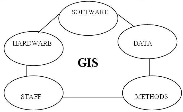
3. ACCOMPLISHING
THE DIGITAL MAP
4. STRUCTURE OF
A G.I.S. APPLICATION