
 Resume
 Abstract
Abstract on the topic of the final thesis
Contents
- Introduction
- 1. Statement of the problem
- 2. Methods and approaches
- 3. Development of the IS structure
- 4. Benefits of implementation
- Algorithms and models
- Results and prospects of implementation
- Conclusions
- List of sources
Introduction
The growth of e-commerce and the increase in delivery volumes create new challenges for logistics companies, requiring the efficient organization of a network of pick-up points (PP). Optimal placement of PP allows you to minimize transportation costs, reduce delivery time and improve the quality of customer service. Traditional methods of planning logistics infrastructure often do not take into account the diversity of factors and the dynamics of modern cities, such as population density, transport accessibility, competitive environment and seasonal fluctuations in demand.
To solve these problems, a modern information system (IS) is needed that is capable of collecting and integrating data from various sources, performing spatial analysis and predictive analytics to support the decision-making process. The use of geographic information systems (GIS) in conjunction with big data analysis methods and machine learning algorithms allows you to automate the collection and processing of information, conduct in-depth analysis and build forecasts. The implementation of such a system allows the company to improve operational efficiency and competitiveness through optimal planning of the pick-up point network.
The purpose of this work is to develop the structure of an information system for analyzing location data and determining the optimal placement of PV, which will improve service availability, reduce logistics costs and ensure effective customer service [1].
1. Statement of the Problem
With the growth of e-commerce volumes and increasing requirements for logistics infrastructure, optimization of the placement of pick-up points (PP) is becoming a key task for logistics companies. An effective PP network allows to reduce transportation costs, increase convenience and availability of services. To solve this problem, the information system must provide a comprehensive analysis of location data. Key aspects of the problem that the system must solve include [2]:
- Data collection and integration
- Spatial analysis
- Population density analysis to identify zones with high demand potential.
- Buffer analysis to assess PV availability.
- Competition analysis to select strategically advantageous zones.
- Demand forecasting
- Route optimization
- Automation of decision making
- Flexibility and adaptability
The system must collect and integrate data on demographics, population density, transportation infrastructure, seasonal demand fluctuations, and the competitive environment from various sources, including GIS and customer preference databases.
Data analysis to identify optimal PV placement zones:
Using machine learning algorithms to predict peak loads and demand dynamics helps to adapt the POA network to changing conditions.
The system should minimize costs by analyzing delivery routes and reducing the time and costs of transport operations.
Based on data analysis, the system provides recommendations for the placement of new POA, based on profitability and demand potential.
The system should be able to adapt to new data and market changes, including adjusting models and integrating additional sources of information.
Example of problem formulation:
The problem of optimizing the placement of PV can be represented as a mathematical model:
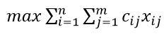
where cij is the importance weight of client j for point i, and xij is a binary variable indicating whether client j is served by point i.
Real example:
In a city with a population of 100,000 people, the system analyzes population density and transport accessibility. Based on the analysis, three optimal zones for the placement of PV are identified, which allows covering 90% of the population with minimal costs.
These aspects ensure the creation of an adaptive and efficient logistics network capable of quickly responding to changes and market needs.
2. Methods and approaches
To create an effective information system that analyzes location data and determines optimal zones for placing distribution points, the following approaches are used:
- Geographical information systems (GIS)
- Population density analysis: identify areas with the highest concentration of customers to increase service availability.
- Buffer analysis: determine the service radii of existing and potential PV to minimize delivery distances.
- Competitive environment analysis: identify areas with low saturation of competitors' PV for strategic placement.
- Data analysis methods
- Clustering: grouping customers by geographic and behavioral characteristics to identify areas of high demand. For example, the k-means method allows you to identify groups of customers located close to each other.
- Regression analysis: forecasting the need for PV and demand volumes by region. Formula:
- Predictive analytics: using historical data to forecast demand, especially in the face of seasonal fluctuations.
- Machine learning
- Customer classification and segmentation: creating customer categories for more accurate logistics planning.
- Seasonal clustering: adapting the PV network to changing demand.
- Predictive models: using regression algorithms and neural networks to identify promising placement zones.
GIS provides integration, visualization and analysis of spatial data, which is the basis for the placement of distribution points. Key methods include [3]:
Analysis of large volumes of data on customer location, demographics, and preferences includes:
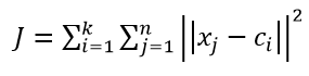
where xj are the customer coordinates, ci are the cluster centers.
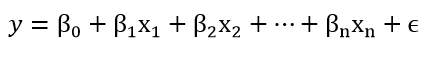
where xi are the factors influencing demand, y is the predicted value.
Machine learning models help identify patterns and forecast demand. Key methods:
Application example:
In a large city, the system uses GIS to create buffer zones around delivery points, which allows identifying areas that can be served within 10 minutes. Population density analysis shows areas with potentially high demand, and predictive models predict an increase in orders on weekends.
These methods provide accurate analysis and planning, adapting the logistics network to changing conditions and increasing its efficiency.
3. Development of the IS structure
To solve the problems of spatial analysis and optimal placement of logistics pick-up points, the developed information system should include all the necessary modules that ensure the achievement of the set goals. The modular structure of the system allows for flexible adaptation of its functionality to specific requirements and ensures high efficiency of operation [4].
The enlarged structure of the designed IS is shown in Figure 1.

Figure 1 – Enlarged structure of the IS
The main modules and their functions are presented in Table 1. This table describes the key components of the system, their tasks and role in the process of spatial analysis and optimization.
Table 1 - Main modules of the IS
| Model | Description |
| Data collection module | Provides for data collection from various sources, including transactional data, consumer preference data, traffic data and social media. |
| Data Cleansing Module | Includes data cleaning, normalization, and integration functions. |
| AI Module | Includes artificial intelligence algorithms to automate analysis and optimize the placement of logistics points. Uses machine learning and predictive analytics technologies to forecast demand, segment customers, and improve the accuracy of models. Includes classification, clustering, and regression analysis algorithms. |
| Data Analysis Module | Spatial analysis of the collected data is performed: population density analysis to identify areas with potentially high demand, analysis of transport accessibility. |
| Modeling | Includes mathematical modeling to optimize the placement of logistics points. Uses coverage and location models, heuristic algorithms and linear programming. |
| Visualization | Provide visualization of data and analysis results. Assists in data interpretation and decision making. |
| Decision module | Supports the decision making process by providing company management with recommendations and optimal solutions based on data and model analysis. |
4. Benefits of Implementation
Development and implementation of an intelligent system for spatial analysis and optimal placement of logistics pick-up points opens up many opportunities for companies [5]:
- Improved operational efficiency: Optimal placement of WP allows to reduce delivery time and reduce transportation costs.
- Improved customer service: Fast and reliable delivery improves customer satisfaction and loyalty.
- Cost reduction: Route optimization and competent resource allocation minimize operating costs.
- Increased competitiveness: Accurate planning of the WP network helps the company stand out from the competition, attracting more customers and improving its position in the market.
Thus, the developed system provides the company not only with a powerful tool for analysis and planning, but also with a strategic advantage in the dynamic logistics market.
5. Algorithms and models
For efficient placement of pick-up points (PP) and minimization of logistics costs, the information system uses a number of algorithms and models. These approaches provide a comprehensive analysis of spatial data, demand forecasting and optimization of logistics networks. The main algorithms and models used in the system include [6]:
- Maximum coverage model
- Minimum Cost Model
- Genetic Algorithms
This model is aimed at selecting such locations for PPs that will provide maximum coverage of consumers with minimum delivery costs. The main goal of the model is to optimize the number of customers located within the service radius of the PP and minimize the distance between customers and the PP. The maximum coverage model helps solve strategic logistics network planning problems because it takes into account which locations will provide maximum accessibility to the target audience.
The minimum cost model focuses on optimizing logistics costs associated with transportation, operating costs, and maintaining the infrastructure of the VP. It takes into account both variable and fixed costs for operating each VP and aims to minimize the total amount of costs. This model is especially useful for companies operating on a limited budget or wanting to reduce operating costs. The model may include a limit on the maximum number of customers served or a minimum acceptable service radius.
Genetic algorithms (GA) are heuristic optimization methods that imitate the processes of natural selection and evolution. These algorithms are especially effective in solving problems with a large number of possible solutions and a high degree of uncertainty. In the context of optimization of placement of PV GA help to find optimal locations that minimize distances to customers and reduce logistics costs [7-8].
The block diagram of the genetic algorithm is shown in Figure 2.
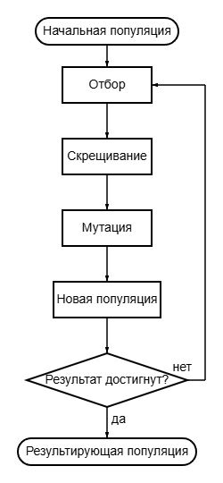
Figure 2 – Block diagram of the genetic algorithm (GA)
The process of the genetic algorithm includes the stages of selection, crossing and mutation, which allows creating new generations of solutions and improving their quality at each cycle. The main steps of the algorithm are presented in the flow chart (see Figure 2), which shows the key stages: formation of the initial population, execution of genetic operations and verification of the achievement of the target result.
6. Results and Prospects of Implementation
Implementation of an information system for analyzing location data and optimizing the placement of pick-up points (PP) provides logistics companies with new opportunities that increase operational efficiency, improve customer service, and adapt business to market changes [9-10].
Implementation Results:
- Improved operational efficiencyThe system optimizes delivery routes and PP placement, which reduces costs, delivery time, and fuel consumption. This is especially important for companies with large order volumes.
- Improved service qualityQuick adaptation to changes in demand and the ability to predict peak loads reduce the risk of resource shortages and increase customer satisfaction.
- Increased competitivenessUsing modern analysis methods and precise planning allows the company to minimize costs and offer favorable conditions to customers, standing out from competitors.
- Reduced infrastructure and transportation costsDemand forecasting and optimization of PV placement help reduce unnecessary expenses on opening and maintaining inefficient facilities.
- Environmental sustainabilityReduced emissions due to route optimization makes the company more environmentally sustainable and enhances its reputation.
Implementation prospects:
- Adapt to ChangePredictive analytics and modeling allow the company to prepare for increased demand, seasonal fluctuations and changes in customer preferences.
- Integration with Other SystemsThe ability to interact with CRM, ERP and external data sources expands the capabilities of analysis and strategic planning.
- Development of AI and Machine LearningContinuous accumulation of data improves the accuracy of forecasts and the efficiency of the system, automating key processes, such as customer segmentation and route determination.
- Expand the network with minimal risksThe system helps to identify strategically important areas for new points, reducing investment risks when entering new markets.
- Optimize Customer ExperienceData analysis allows you to offer customized solutions, such as flexible options delivery, which increases customer loyalty.
- Social responsibilityThe system promotes environmental initiatives by optimizing logistics, which strengthens the company's position in the context of growing attention to sustainable development.
- Innovation and researchAnalysis of the collected data opens up new opportunities for product development, such as innovative delivery formats and improved logistics models.
Overall, the implementation of such a system provides the company with an immediate increase in efficiency and provides a strategic advantage in the long-term, allowing it to be flexible and competitive in rapidly changing market conditions.
Conclusions
Development and implementation of an information system for analyzing location data and optimal placement of pick-up points is an important step in creating an efficient logistics network. The use of spatial analysis methods, machine learning and optimization models allows you to make informed decisions, increasing operational efficiency and reducing costs.
The use of GIS and predictive analytics improves availability and delivery speed, which helps meet customer expectations. The system's ability to integrate data from various sources allows you to take into account many factors when choosing zones for placement of pick-up points, making the network more flexible and adaptive to market changes.
In addition, the implementation of such technologies supports sustainable development goals by optimizing routes and reducing emissions. The creation of an intelligent system for PO placement provides the company with tools for strategic planning, increases its competitiveness and ensures flexibility in the long term.
List of sources
- Optimization of logistics processes in marketplaces to improve efficiency and quality of service [Electronic resource] / Internet resource. – Access mode: https://logists.by/blog/optimization-of-logistics-processes-in-marketplace-to-enhance-efficiency-and-quality-of-service – Title. from the screen.
- Logistics for online stores: guidance and advice [Electronic resource] / Internet resource. – Access mode: https://logistics.by/blog/how-to-optimize-online-store-logistics-to-increase-delivery-efficiency-and-meet-customer-needs – Title. from the screen.
- USE OF GEOINFORMATION SYSTEMS IN SOLVING LOGISTICS PROBLEMS [Electronic resource] / Internet resource. – Access mode: https://cyberleninka.ru/article/n/ispolzovanie-geoinformatsionnyh-system- pri-reshenii-logisticheskih-zadach/viewer – Title. from the screen.
- Shestakov, B. A. Information system for spatial analysis and optimal placement of logistics points / B. A. Shestakov, N. TOWARDS. Andrievskaya // Computer Science, Control Systems, Mathematical and Computer Modeling (IUSMCM-2024): Proceedings of the XV International Scientific and Technical Conference within the framework of the X International Scientific Forum of the Donetsk People's Republic, May 29-30, 2024. – Donetsk: Donetsk National Technical University, 2024. – S. 684-689.
- Logistics system optimization — key strategies and technologies to improve efficiency and reduce costs [Electronic resource] / Internet resource. – Access mode: https://logists.by/blog/logistics-system-optimization-key-strategies-and-technologies-to-improve-efficiency-and-reduce-cost – Title. from the screen.
- Logistics optimization: effective methods and strategies [Electronic resource] / Internet resource. – Access Mode: https://logistics.by/blog/economicheskaya-effectivist-optimizaczii-logisticheskih-proczessov-kak-povysit-effectivist-i-socratic-rashody – Title. from the screen.
- Genetic algorithm - Wikipedia [Electronic resource] / Internet resource. – Access mode: https://en.wikipedia.org/wiki/Genetic_algorithm – Title. from the screen.
- Genetic algorithms: efficient solution of optimization problems [Electronic resource] / Internet resource. – Access Mode: https://ya.zerocoder.ru/pgt-geneticeskie-algorithmy-genetic -algorithms-efficient-solving-optimization-problems/ – Title. from the screen.
- Implementation of information systems for effective warehouse management [Electronic resource] / Internet resource. – Access mode: https://www.gmcs.ru/press-center/press-about/vnedrenie-informacionnyh-system-dlja-ehffektivogo-pravlenija-skladom/ – Title. from the screen.
- Digitization of logistics - advantages and challenges of the new era [Electronic resource] / Internet resource. – Access mode: https://logistics.by/blog/czifrovizacziya-logistiki-preimushhestva-i -vyzovy-novoj-ery – Title. from the screen.