Abstract
Kochin Yuriy Evgenyevich
Theme of my master's work: "The development of mine workings three-dimensional model development at A.F. Zasyad'ko nime"
1. General information
Traditional geologic-survey information about mines is collected in mine workings plans for developed coal-seams. Mining plan is a graphic document of 1:5000 scale, which describes mine roadways network in a particular coal bed and bearing strata. It is (was) used during its development from the beginning. Seams also reflect:
1. Mining and geological conditions in the form of working depth isoline (contour line), factual bed attitudes, seam structural column, location of zones of lithologic composition change of bearing rock, coal quality indices, reserves calculation, location of predicted and uncovered by workings disjunctive break-downs, etc.
2. Mining and technical conditions in the form of monthly and annual production and development faces advance, extracted seam thickness, enumeration of technical means of extraction and drifting, method of strata control, air consumption, cross-cut, zones of unsatisfactory conditions, zones of gas-dynamics, outbursts, blowers, etc.
3. Results of survey measurement in the form of development workings attitudes, locations of survey networks points, marks of foot walls, seam and bearing strata cleats, etc.
With deepening of mine workings in old developments of seams, especially in case with a number of seams, flat graphic maps and models are not informative and functional enough. This is conditioned by the fact that in order to ensure safety and efficiency of mine workings it is necessary to solve a lot of geometrization problems: how to determine the distance between the elements of technological scheme and massif in mining lease, how to assess curvature of bed attitude, build projections of coal pillars on adjoining seams, determine massif folding parameters, etc. This leads to necessity of developing solid models of deep mine workings, and on their basis to work out optimal solution to plan and advance mining workings.
The aim of this researchThe aim of this research is development of a solid model of the most complicated and problematic mine after A.F.Zasyadko, which is at present developing 4 outburst-dangerous seams at depths between 1100 and 1350 m, it is also characterized by the longest and most complicated system of uncovering, preparing and development workings.
2. Review information
At present information systems of geologic-survey divisions and technical services at mining enterprises develop in several directions.
The first direction is presented by systems oriented at work with open mining operations. "ASMO" is among these systems. It was developed by scientists of DonNTU. [2]
The other direction is those information systems oriented at surveying tasks for underground mines. “SAMARA” is one of them.
There are a few systems allowing to project mine workings development on the basis of developed models and models of geological structure.
These functions are most widely represented in the system Mine2D-4D.[7]
The structure of program complex consists of:
1.Program of mining plan creation
2.Program of cross-cut construction..
3.Programs of breakage blocks design.
4.Program of calculation of mineral extraction sequence.
5.Programs of mine planning presentation.
An important disadvantage of this system is its direction at constructing models for ore deposit development. In this connection at present a topical question is development of mine workings projection on the basis of existing mining models and geological structure of a mining massif. The basis of this system is a 3-d model of mine workings network.
3. Conclusion
Development of a 3-d model of mine workings network is a difficult engineering task. For its solution the program complex V-3d has been developed.
It is based on the most popular program packet AutoCAD. Using this product and external data base it is possible to present mining models visually.
To simplify the initial information entrance electronic plans of mine workings were used. Picture 3.1.
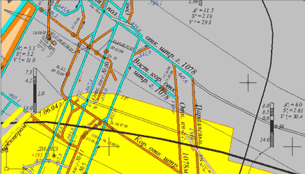
Рис. 3.1 – piece from the plan of mountain works of A.F. Zasyad'ko nime
Entering and editing information is done with the help of program module with the interface, which is presented in Picture 3.2.
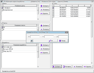
Picture 3.2 – Interface of input of information routine from the plan of the mountain making
Structure of “external” data base, received after entering information, is shown in Picture 3.3
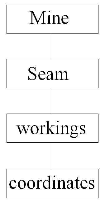
Picture 3. Hierarchical structure of data base for constructing a solid model of mine workings network.
Table 1 “Mine” includes the list of the used mine field blocks, where mining network is situated.
Table 2 “Seam” includes the list of all developed seams and insets.
Table 3 “Workings” has the enumeration of all the mine roadways and their type (in-seam or non-tabular).
Table 4 “Coordinates” has coordinates of all workings with connection to mine survey.