Source of information: http://www.tu-cottbus.de/sfb_trr/eng/site_ezg.htm
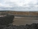
Daily webcam picture from the catchment area


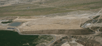
As the central investigation site of the SFB/TRR the Brandenburg University of Technology at Cottbus planned an artificial catchment area for scientific use together with the mining company Vattenfall Europe Mining AG. The post-mining landscapes of the Lusatian lignite mining district (Eastern Germany) offered the necessary technical prerequisites and land for the construction of an artificial water catchment area at the landscape scale. The construction of the site was realized between 2004 and 2005 in the open-cast mine Welzow-South (20 km south from Cottbus). It has been named "Chicken Creek" ("Quellgebiet Huhnerwasser") after the small stream existing here before mining started.
Location of the open-cast mine Welzow-South
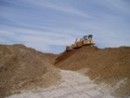
The site has been constructed as the headwaters for the "Chicken Creek", which had been previously affected by mining operations. It covers an area of approximately 6 ha. The mining company itself gained first experiences within another smaller catchment area close-by ("Neuer Lugteich"). Like this first artificial water catchment the "Chicken Creek" catchment was constructed by means of large dumping devices from the lignite open-cast mine. On top of the base layer above the surface of the initial deposits, a clay layer of 2-3 m thickness has been dumped. First experiences from the "Neuer Lugteich" revealed that this clay layer is an optimal vertical barrier for seeping water. Overlaying of the clay is approximately 2-3 m of sandy quaternary substrate which has been applied as the top layer. The surface has been levelled by caterpillars and tracks were removed by final flattening.

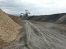
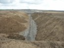
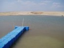
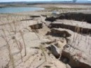
The catchment has been constructed as a small hill with an altitude difference of approximately 10 m and an approximately slope of 2%. A small lake has been left to develop at the deepest part of the site which allows for limnological investigations. Further, small streams may develop in erosion gullies with temporary and probably permanent runoff. A weir at the outlet of the lake will be the base for balancing and hydrological modelling. The "Chicken Creek" stream will be developing downriver of the catchment area and will provide additional possibilities for investigations of initial stream development.
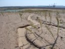
Typical mining specific conditions have been excluded while planning the site. Especially the widespread phenomena of strong soil and water acidification due to pyrite oxidation (acid mine drainage) has been avoided by choosing adequate substrate. Accordingly tertiary pyrite containing substrate was excluded during the dumping process. The substrate of the catchment stems from sandy accumulations of Pleistocene age and is free from pyrite and lignite. Furthermore, no amelioration measures such as liming or fertilization have been carried out, with the exception of the final leveling of the surface by caterpillars. The site was not replanted so that a site specific unaffected succession may occur.
After construction works were finished in September 2005 and the area subsequently fenced, Vattenfall Europe Mining AG entrusted the area to the Brandenburg University of Technology at Cottbus for scientific purposes. With the end of the construction work ('point zero' of the ecosystem development) in autumn 2005 the first measuring devices were installed, in order to document the initial state of the system as well as to study the genesis of structures. An extensive monitoring programme was launched to document the structural development of the system. Two weather stations register input parameters and a weir measures the groundwater discharge. A 20x20 m grid has been marked off and soil samples have been taken along this grid immediately following the end of construction works. Groundwater gauges were installed down to the clay layer to measure the groundwater level, while permanent soil profiles allow the access to deeper parts of the substrate.p>
Overview of installed measurement devices in the catchment area