
Lyogkih Eugen Alexandrovich
Faculty: radiotechnicsSpeciality: "Technical protection of information"
Scientific Supervisor: Prof. Chichicalo Nina Ivanovha
Abstract of the Qualification Master’s Work
Introduction
Tall buildings are classified as city objects, an emergency condition which can lead to catastrophic consequences, so that each building must be implemented by an integrated security system. One of the most important elements of this system are the measures for early detection of possible building collapse under the influence of natural and anthropogenic influences, and, especially, such as wind loads, industrial dynamics, changes in ground conditions under the object.
Actuality
Modern building is characterized high rates and large volumes of the erected buildings, and also by active introduction of new decisions on all of the stages of building.The modern hardwares of the geotechnical monitoring become the necessary attribute of building of difficult buildings and buildings. They allow to carry out operative control of the state of the created or on-the-road build building, taking into account the got information correct project and technological decisions if necessary, to promote reliability and operating safety of the erected objects.
It is impossible beforehand to provide for, model and take into account all of variants of change of external factors (geological, technogenic, natural, anthropogenic) of affecting a build object in the process of his exploitation. However, and it is extremely important to realize it at planning, it is possible to develop and set the device of control of orientation after the state and stability of basic elements of determining operating safety of building is foundation, walls, ceilings, supporting columns, roof, bearings and power elements of construction.
Thus, the issue of the day to date is development of various devices and systems of monitoring of constructions of buildings and buildings, and introduction them in practice of building.
Review of methods
The state-of-the-art review of existent methods of control was made for this purpose:
- the use of satellite methods of measurings;
- laser scan-out of buildings;
- method of the geometrical leveling;
- fiber-optics measurings systems;
- magnetic sensors of spatial orientation;
- he use of accelerometer.
Considered methods and devices of determination of spatial orientation of objects in points among all of failings, have one very substantial – they are too dear, for the use as stationary measurings devices at monitoring of buildings and buildings. Presently control of displacements, vibrations and rejections of objects conducted city services at certain intervals of time (one time in 5 years), but not which constructions, as often is in our time, and remain regardless quite. This question acquires the special actuality in connection with the collecting presently high rates of building, especially in unfavorable in geological relations districts to which our behaves and city. The devices of control, for the receipt of mass distribution, must possess a low cost and in also time to provide sufficient exactness. Because of these reasonings, it is suggested as prototypes to utillize the next sensors of spatial orientation. Akselerometry well befit for the use as sensors of control of perimeter of build ings and building, as allow with sufficient exactness to determine the vibrations (displacements) of objects. For the use as a sensor of inclination, accelerometers does not fit, as in the case of gradual the accumulation of tensions, deformation of object, can take a place gradually with speed which they are not sensible to. In this connection for basis of sensors of control of vertical line of buildings and buildings it is suggested to utillize the magnetic sensors (inclinometers) of spatial orientation of objects.
Raising of control task
The device of determination of spatial orientation of objects is intended for the objective high-fidelity measuring of moving (inclination, vibrations) of the controlled objects (buildings, buildings) and elements of constructions from initial position, communication of data for a subsequent reflection, treatment, storage, and notification in the case of emergency situations. The designed device is intended for measuring of displacement, vibration and inclination of object.
As the recommended conceptual decision it is possible to offer following. Application of integral accelerometer and magnetic sensors will allow to transform moving (vibrations) and rejections of object from a vertical line in electric signals.
In the process of measurings it is possible to make both a few read-outs of the controlled information at stated intervals and to conduct continuous in time control of object.
Monitoring will be carried out using a wireless system. Wireless monitoring system consists of several different components, which are shown in Fig. 1. The monitoring system should provide for the transfer of data from the controlled structures without their visual inspection. Measurement data from sensors can be transmitted to the user in various ways, this diploma is considered the method of transmission is based on technology ZigBee. Several sensors are combined into a network forming "nodes" that have the power supply and can transmit their own signals only over short distances. Therefore, the facility installed a central device that collects and stores information in a database for analysis from various sites. These data are used to assess the current state of the structures and in the event of an emergency message is issued in the form of an alarm. The central unit should also perform the calibration of sensors and nodes provide reprogramming yes tchikov keeping the whole system flexible. The central unit should usually has a personal computer with a constant source of nutrition and related programs.
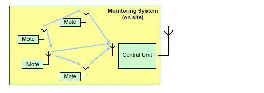
Figure 1 Schematic diagram of a wireless monitoring system (3 frames, size 56.2 kb)
The monitoring system should provide for the transfer of data from the controlled structures without their visual osmotra.Neskolko sensors are combined in forming a network of "nodes" that have the power supply and can transmit their own signals only over short distances. Therefore, the facility installed a central device that collects and stores information in a database for analysis from various sites. These data are used to assess the current state of the structures and in the event of an emergency message is issued in the form of an alarm. The central unit should also perform the calibration of sensors iobespechivat reprogramming of sensor nodes while maintaining the whole system flexible.
Findings
Thus, having analysed problems and operating conditions of the developed device, and also having analysed existing methods of measurement of controllable size, as primary measuring converters for the device of the control of the loaded condition of buildings magnetoelastic sensor have been chosen.A task in view on designing for the developed device substantive provisions of the technical project also are developed, according to the rough block diagram of the projected device is developed.
Literature:
- Ăčíçáóđă Â.Á. Ěŕăíčňîóďđóăčĺ äŕň÷čęč. – Ě.: Ýíĺđăč˙, 1970. – 72ń.
- Âîđîáüĺâ Ń.Ŕ. Ýëĺęňđč÷ĺńęčĺ čçěĺđĺíč˙ íĺýëĺęňđč÷ĺńęčő âĺëč÷čí. – Ńâĺđäëîâńę:ÓĎČ, 1975. – 231ń.
- Ăóěŕíţę Ě.Í. Ěŕăíčňîóďđóăčĺ ńčëîčçěĺđčňĺëč. – Ę.: Ňĺőíčęŕ, 1981. – 183ń.
- Áŕđŕíî÷íčęîâ Ě.Ë. Ěčęđîěŕăíčňîýëĺęňđîíčęŕ. Ň. 1. – Ě: ÄĚĘ Ďđĺńń, 2001. – 544 ń.