|
Ivanov Artem Мining-geological Institute The Mine surveying Department |
RUS |
UKR |
ENG DonNTU | Master's portal |
|
main abstract |
Theme of master's work: Geological cross-sections' construction according to the exploratory wells in a free direction Scientific adviser: doctor of science Grischenkov Nickolay |
 |
Summary of research and developments
Content
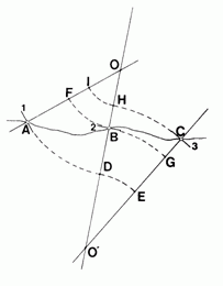
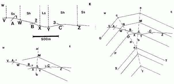
1. INTRODUCTION 1.1. Topical issue Constantly growing demands on the reliability of survey data and the accuracy of their graphic display. The main results of exploration of coal deposits are submitted to the geological sections used for further surveying work. The accuracy and reliability of geological cross-sections depend not only on the complexity of geological structure, detail and quality of exploration, but the accuracy of the coordinates of points of the meeting wells layer. Construction of geological sections - a complicated and time-consuming task, which is necessary to define, build and agree on a unified system of a large number of structural and geometric elements. 1.2. The purpose and objectives of research Objective. Improved methods of constructing geological cross-sections according to the intelligence of wells through the application of mathematical statistics and computer graphics. Research problems: an analysis of existing methods and practices of construction of geological sections according to the wells, analysis of existing methods for construction of geological sections and their shortcomings, the impact of errors in exploratory wells in the methodology and the accuracy of geological faults, causes and patterns of curvature of the wells, the impact of errors in determining coordinates of points of exploration wells the accuracy of the construction of geological sections in an arbitrary direction. 1.3. The idea of work and research object The idea of work. Installing dependencies construction of geological sections in an arbitrary direction. The object and subject of study. The object of study is the method of construction of geological sections in an arbitrary direction, the subject of the study are data intelligence wells. 1.4. Scientific novelty and practical significance of the results Possible results are expected in the performance of their novelty and significance: the construction of geological cross-sections according to the intelligence of wells through the application of mathematical statistics and computer graphics. Planned testing results (participation in conferences, submission of work for the competition, publishing, filing patent applications, etc.). Report on the conference, a presentation to the contest. 2. Overview 2.1. A review of research on the topic in DonNTU The department "Surveying", Donetsk National Technical University of dealing with this issue: Grischenkov N.N., Mirny V.V., Filatova I.V. Professor, Ph.D. Grischenkov N.N. conducts research in the field of geographic information systems in the mine surveying and mining. He is the author of over 110 scientific papers, a number of software systems that have passed state acceptance tests and exploited in mining enterprises of Ukraine and other CIS countries. Professor, Ph.D. Mirny V.V. engaged in specialized areas of the geometrization of mineral deposits, the author of over 130 publications in these areas, including the co-author of a textbook for high schools "Mine Surveying" (Moscow, "Nedra", 1981.). Associate Professor Filatova I.V. is a specialist in processing the results of exploration of coal deposits and their further geometrization. He is the author of many scientific papers, articles and publications on the subject. 2.2. A review of research on the topic in Ukraine In Ukraine, the issue involved the Department of Surveying of the Donetsk National Technical University, Dnepropetrovsk Mining Institute and the Research Institute UkrNII. Questions of geometrization of mineral deposits and the mathematical solution of practical problems involved Ogloblin DN, Gerasimenko GI, Omelchenko AN etc. NN Pogrebnoy, VV Troshchenko worked in establishing a system of geometric spatial modeling of coal deposits. 2.3. A review of research on the topic in the world In Russia, the issue involved in the St. Petersburg State Mining Institute named after Plekhanov, Ural State Mining and Geological Academy, the Ural Mining Institute, Sverdlovsk Mining Institute, etc. It should be noted the work of AN Petrov and the staff led them to the laboratory, working with the FEB RAS. They deal with various aspects of tectonics and structural geology. It is used in everyday research computing capabilities of personal computers, forcing them to formalize their tasks. Abroad, there are some teams who are developing applications to address the structural-geological problems. Among them can be identified Schlumberger, Midland Valley and Cognisers Development. The overwhelming number of studies focus on statistical analysis of geological data. Among them we can highlight two volumes of statistical data analysis in geology "(JS Davis), in which material well-systematized and adequately disclose the possibility of using statistics and some of its related disciplines in geology. Also, there are many interesting and significant works on the subject by authors such as Epard, Groshong, Fernandez, Munoz, Arbues, Homza, Wallace. 3. HIGHLIGHTS OF WORK 3.1. Methods of constructing the section of the well-known dip Often the problem is the need to build a section of data on cell abundance and location of boundaries suites (usually this is the map, route monitoring and data drilling). Construction of the section is possible only if certain assumptions about the form of folds. Namely, the fold should be close to cylindrical or, at least, it should consist of fragments that have a cylindrical shape. This flexure must be contour lines. Among the methods of constructing the section of the known elements of the occurrence of the most widely distributed the following: Busca-Weber method, the method of kink-bands and the method isogonic chart. Moreover, the use of a method in many cases determines how the right is built section. For this reason, before you start building a cross-section, you must carefully examine all available material, and only then choose the method and to begin construction. Must also remember that if we use an element occurrence is not directly on your profile, its position on the profile is defined as the projection of parallel hinge folds, and taking into account the hypsometric marks, which was itself outcrop. 3.1.1. Method of Baska-Weber (method of radius) This is probably the very first method of constructing the cut, which received scientific justification. The method was proposed almost simultaneously in the 20th - early 30's, the English geologist Bascom and Russian scientists Weber. The method is applied to concentric folds with rounded hinge zones. The maps are characterized by a gradual change in the folds of the angles of incidence on the wings fold. The method is shown in Figure 3.1. It is assumed that we know the elements of the occurrence of layers in the points A, B and C.
Consider the sequence of actions necessary for the construction of the section. First, spend perpendiculars to dip rendered in profile, and find the point of intersection perpendicular to the adjacent elements of occurrence. Then, from the points of intersection of two perpendicular between them build arcs through the appropriate dip. Arcs "broken" to finish building layers, using the same method. This method allows the introduction of amendments, if its direct application leads to mistakes. An example of such a case is shown in Figure 3.2. This assumes that we know the elements of the occurrence at points A, B, C and D. It is assumed that the points A and D goes one and the same horizon, tracking the horizon from the point A leads to point G, but not D.
This amendment introduced at the site where we have the smallest number of observations, ie the greatest arc of a circle. Adjusted section is constructed as follows. A common way to construct an arc from points A and G. In neighboring perpendiculars obtain points E and W, which connect a straight line EW. Coming through the points E and W tangent to the arcs of circles conducted, ie, normals to the lines OE and QC. Perpendiculars intersect at the point R, from which the line EW goes perpendicular, intersecting the already constructed radii at the points T and S. Dougie EH and HW rebuilt as if the point S and T would be the centers of the circles. At the same time perpendicular to the line RTS at the point U is an intended element of bedding necessary to connect the horizon, exposed in the points A and D.
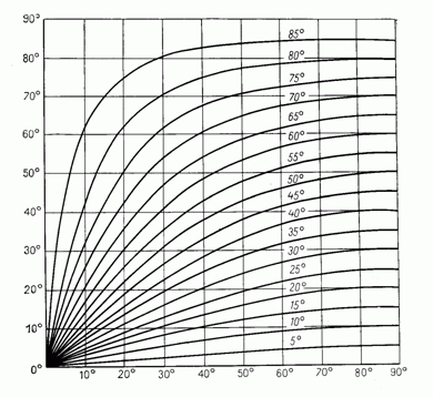
Method of Baska-Weber can be used as a profile, and to the oblique cross sections. In the latter case, however, the profile should be imposed not true dip and apparent tilt angles, which can be calculated by the nomogram in Figure 3.3. This nomogram can be used in different cases, when necessary to determine the apparent angles of incidence. Method of Baska-Weber gives good results in the strip between the closest point, taken as the center of the circles of which are held arc circles of different radius. Outside there are sharp-angled point with infinite curvature (singular point), and the structure itself is represented by shallow. An example of this effect is shown in Figure 3.4.
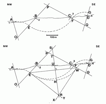
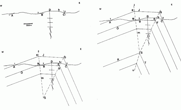
3.1.2. The method of kink bands The method developed in the late 60th - 80th years and now has a wide distribution. It applies to folded structures, with broken wings and flat zone hinges, that is composed of kink bands. On the maps, such structures are characterized by zones, within which is dominated by similar items of bedding, that is a discrete set of possible values of the angles of incidence. The boundaries between the zones are sharp and are held on the plane. The method of kink-bands can be used both for folds with constant and variable, the true power of the constituent layers. 3.1.2.1. Folds with constant power The method described in the example of figure 3.5. There is a profile within which the exposed stack of sandstone, shale and limestone, and at points A, B and C measurements made dip. Established that the limestone outcrop in the core anticline.
Construction of the cut is done by tracing boundaries closest to the measuring point dip. Consider the sequence of actions. We first determine the position of joints and the axial plane of kink bands. If we do not have additional data, then through points X and Y hold the line with the same slopes layers, as in the points B and C, respectively. The break contact of the limestone / shale (Ls / Sh) occurs at the point L. Through the point L bisect the angle XLY - line ab, which is the axial plane of kink-band on the east wing of the folds. A point Z rebuilt Contact sandstone / shale to the intersection with ab at the point M, and then continues along this boundary segment XL. Coming through the point W is held contact sandstone / shale with a slope at point A to the intersection at point N with its fragments, drawn from the point M. A point N bisect the angle WNM - line cd, which is the axial plane of kink-band on the west wing of the folds. Now, knowing the position of axial planes, reconstruct the situation of the other contacts. At the point e 2 axial plane are joined into one, which continues along the bisector cea. Layers erected parallel to the layers on the wings fold. 3.1.2.2. Layers with variable capacity This assumes that the various wings of the layers have different power. In principle, the approach is the same as for the concentric folds, but it requires the availability of data at different altitudes. These data are necessary for the allocation of kink bands in the section. It is assumed that the points A and C goes the roof of the same horizon at the point B - its sole, but at the point h the border zone - the axial plane of kink-band. Figure 3.6 is assumed that the measurements are made also in the well, but they might as well be made on the mountainside. The sequence of construction of the section following. First, hold the axial plane of kink-band hi. Then, parallel to the layers at points B and C hold straight segments CGJ and BEF with the inflection point G and F. It should be noted that due to changes in capacity on the wings of the axial plane is not the bisector angles CGJ and BEF. To determine the position of the second axial plane (lm), we need additional data on changes in capacity on the wings and the castle folds. If they do not exist in this part of the structure, we assume constant power and restored the structure as well as in the previous example - determine the position of point K as the intersection of the next layer from point A and continuing through GJ, bisect the angle of AKG, rebuilding a line BNO.
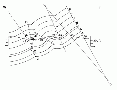
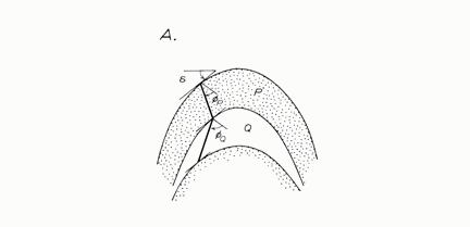
After connecting the axial planes hi and lm together at the point S, we estimate how much the power of layers in different wings, and restored the layers, preserving the proportional change in the thickness of the layers. In this case, the position of a single axial plane is obtained automatically on the break points of the layers. 3.1.3. Method isogonic chart The above methods of the radii and kink bands are applicable only subject to a number of conditions, and, above all, they are good only for relatively simple folds. However, in the inner parts of the fold-thrust systems, the folds have a very complex shape with significant changes in power on the wings and in the castles of folds, which can not be considered as simple ways. In such cases, the incision rebuilt "by eye" - according to the dip in the surface layers are extrapolated inwards, with the shape of the folds are often no restrictions. Nevertheless, although the general methods of constructing the cuts in such situations does not exist, it is possible to form an approximate estimate of folds, which allows us to cut more reliable. This method is referred isogonic chart. Magnetic curve - a line connecting points on the surface layers, the tangents to which are inclined at the same angle to the axial plane of folds. If we can draw the magnetic curve, we can recover and dip of the strata, and, therefore, accurately portray them in perspective. Thus, the main task is to find a method to determine the position isogonic chart. Although the universal method and does not exist, but is generally considered that the shape of the folds does not depend on their size, and lithology of the crushed segments and, therefore, to study the behavior isogonic chart can be used outcrop scale folds. Another option - use of profiles, constructed by other methods to restore the geometry of the at least one typical folds. So, let's say that we need to rebuild the section of a deformed sand-shale strata in which the majority of small folds have a form close depicted in Figure 3.7. For both varieties of rocks (sandstones and shales) prepared a graph of the angle of inclination isogonic chart on the angle of bedding. Once such a plan is drawn up, from the points of measurements made on the surface of dip (say, among the slates) isogon rebuilt. The boundary of sandstone and shale is carried out "by eye", but in view of the data on the elements of occurrence along isogonic chart. Then, given the chart data isogon erected inside a layer of sandstone, and held his foot, etc. Constructed in this way the incision is usually quite reliable within the region, where there is actual data, and leads to significant errors beyond.
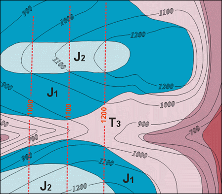
3.2. Method of horizontal Horizontal called a line belonging to any bedding surface and located at a certain height. These lines can be compared with contours describing the terrain, with the difference that stratoizogipsy describe the surface layer (the roof or the sole). The method of constructing geological cross-sections through horizontals used in cases where we do not have enough dip measured in field work. In this case, it is impossible to apply the methods discussed above. The method is simple enough. Figure 3.8 shows horizontal constructed for the boundary between rocks of different ages (J1 and J2). To find them enough to connect the appropriate height point of crossing the border J1/J2 with contours. Next, following the line of the cut and drift on the plane profile of each point of intersection with horizontal the height of the latter. Thus, the profile is a set of points, connecting that we obtain the boundary for which were built horizontal. Repeat for other boundaries, we find their position in the division. The described technique is essentially the calculation of dip monocline fold sites with horizontal position of the hinge. In this case, the angle of incidence graphically determined for differently oriented lines of the cut - both during its transect, and at non-perpendicularity orientation to the strike of the layers. It is not necessary to use the nomogram presented in Figure 3.3. The disadvantage of this method is the fact that its application requires that the terrain was quite broken up.
Method of horizontal, in the traditional sense, is applicable only to sites monocline folds, having a horizontal hinge. In this case horizontal lines are straight and are located approximately parallel to each other on the map. It is for these structures is a program written by the author as a demonstration of the basic block algorithm, considered in this study. However, we can assume that the method can be applied to the folds, whose joints are oriented in an arbitrary manner. In this case horizontal become curved lines. 4. CONCLUSION The increased level of complex mechanization of mining operations are constantly increasing demands of industry to the reliability of survey data and the accuracy of their graphic display. The main results of exploration of coal deposits are presented on the vertical geological sections and plans hypsometric layers, which are used in the calculation of reserves, design, construction and operation of mining enterprises. Accuracy and reliability of geological faults and hypsometric plans depend not only on the complexity of the geological structure of the mine field or plot detail and quality of exploration, but also on the accuracy of the coordinates of points of undercutting recovery wells and methods of structural constructions. Construction of geological sections - a complicated and difficult task, in which you want to define, build and link a single geological concept of a large number of structural and geometric elements - points, lines, angles, elevations, and surfaces. Often, the researcher is faced with the choice of two or more possible solutions to the most plausible. This is perhaps the most difficult and important cases in the geometrization deposits. The proper solution of such problems depends on the experience of a geologist, his ability to use modern methods and techniques of structural models, and available data on the structure of the site. Effectiveness of the excavation units and powered supports a large extent determined by the constancy of mining and geological conditions. It is therefore very important problem is to increase the resolution of the exploration and methods for graphical display of geological information. It requires, in particular, improve the accuracy inclinometric filming wells. Without this it is impossible to solve the problem of increasing the resolving power of exploratory drilling and, hence, detection and geometrization of small-amplitude disturbances. With increasing depth exploration and use of directional drilling improve the accuracy of directional wells is becoming increasingly important. In structural models, using geological, geometrical and mathematical methods. And the more closely they interact and complement each other, the more perfect method of geometrization of coal deposits, authentically and accurately obtained on the basis of its geological sections. 5. REFERENCES
RUS | UKR | ENG || DonNTU | Master's portal Ivanov Artem © 2010 |