
1. GENERAL DESCRIPTION OF THE WORK
1.2. Connection of work with scientific programmes, plans, themes
1.10. Author's personal contribution
2. ANALYSIS OF THE PREVIOUS RESEARCHES
3.1. Methodology of geochemical researches
3.2. Methodology of geophysical researches
4.1. Results of geochemical researches
4.2. Results of geophysical researches
THE LIST OF THE USED LITERATURE
The theme is actual because the area of coarticulation of Donbass with Priazov'e is a deep rift. By this rift goes discharge of the substance. Numerous explosive infringements, a wide variety of breeds, numerous displays of the ore and a small the power of sediments contribute to the accumulation of many heavy metals in soils. Faults zones, which are overlapped by quaternary sediments, have a different activity and permeability and in different ways have an impact on the accumulation of toxic substances in soils. By the way the composition of soil-forming rocks also have an influence on the composition of the soils. A lot of soil-forming rocks contain elements in concentrations, which are dangerous for human. In connection with this the establishment of such dangerous areas is an actual problem and should be realize by the complex of new geophysical (structural and geodynamic) and traditional geochemical methods.
1.2. Connection of work with scientific programmes, plans, themes
Work is associated with scientific-research work of the department of the usefull minerals and ecological geology N8-07 “Research of the geological features and the structure of zones of the ecological risk of Donetsk region and elaboration of the methods of its forecasting”, with the theme “The preservation of the environment and steady development” the main scientific trends and major problems of the fundamental research in the field of natural, technical and humanitarian sciences in 2009-2013 years.
The purpose of research is the establishment geophysical and geochemical features of of breeds and soils of the area of coarticulation of Donbass with Priazov'e, which allow to identify ecologically dangerous areas of lands of agricultural fixing.
1. The analysis of the modern condition of a problem by the published data and the fund materials.
2. Carrying out of geophysical field researches by the method of SGDM-A and the establishment the features of the fault zones in an electromagnetic field, appraisal of their permeability for the toxic elements.
3. Establishment the nature of the influence the indigenous breeds composition on the concentration of toxic elements in soils by geochemical data.
4. Construction the maps of the geochemical anomalies by the elements, which exces the maximum allowable concentrations and the regional background.
5. Elaboration the recommendations by the forecasting the ecologically dangerous plots of land of the agricultural appointment.
Breeds and soils of Komsomolsky, Kamishevahsky and Petrovsky lots of the area of coarticulation of Donbass with Priazov'e.
Geophysical and geochemical features of breeds and soils of the area of coarticulation of Donbass with Priazov'e.
Geophysical methods (azimuth way of the structural and geodynamic mapping); geochemical methods, methods of the mathematical statistics data processing.
There was established the features of the influence geologic, tectonic and geodynamic factors on the formation of ecologically dangerous concentrations the chemical elements in the soils of the area of coarticulation of Donbass with Priazov'e.
The researches, which were made, allow to highlight the dangerous areas, which are connected with natural anomaly of geological and tectonic nature in the soils. This approach allows to to differentiate the lands of the agricultural appointment by their value and ecological safety.
1.10. Author's personal contribution
Carrying out of geophysical field researches and detection of geophysical anomalies, establishment the nature of dependence the composition of soils from the type of the underlying breed; clarification the features of the accumulation the chemical elements in soils over the fracture zones; construction of ecological-geochemical maps and establishment the areas of the pollution.
The results of researches reported at the conference “Geography, geological ecology, biology, geology: the experience of scientific researches in the context of international cooperation”, 2010 y., DNU them. Oles Gonchar, Dnepropetrovsk; at the conference “Geography, geological ecology, biology, geology: the experience of scientific researches in the context of international cooperation”, 2011 y.,DNU them. Oles Gonchar, Dnepropetrovsk; at the conference “Modern trends of the scientific paradigm of the geographical education in Ukraine”, 2010 y., DISE, Donetsk; at the conference “Protection of the environment and the rational use of natural resources”, 2010 y., DonNTU, Donetsk. There are 4 publications by the theme of the work.
The complex of methods of structural and geodynamic mapping (SGDM) was developed in the 70-s years of the last century to estimate the modern tectonic activity structures. The founders of these methods are Y. Riaboshtan and E. Tahtamirov. One of the most fast methods of this complex is the electromagnetic azimuthal [1б с. 97]. The researches with this method were carried out by V. Aliohin to study the features of the transport of energy and matter [2, 3]. The author established, that along the tectonically active structures occurs flow the energy and the substance, marks the formation of deposit and occurrences by endogenous genesis of different age.
There was a small amount of geophysical researches by the SGDM method within the area of coarticulation of Donbass with Priazov'e. There were not researches of this kind on the same plots of the area of coarticulation of Donbass with Priazov'e (Komsomolsky, Kamishevahsky and Petrovsky). It will be realized there at first.
Researches of I. Usenko, L. Bernadskaya, G. Makuhina, D. Eisenberg, Y. Ustinovsky, B. Panov and many other are devoted to studying geology and ore-bearing of the area of coarticulation of Donbass with Priazov'e (fault zone of Volnovaha) [4]. A summary of long-term studies of this area is shown in the monography of S. Nechaev “Mineralization of the Volnovaha fault zone”. The researchers of this zone set that the majority ore complexes tend to bursting structures of the site. To these complexes belong conductor of the cobaltist pyrite, calcite, dolomite veins of quartz, the points of the mercury and fluorite salinity and other metals.
B. Panov's and V. Aliohin's work “Structural-tectonic features and mineral composition of the new polymetallic manifestations of the zone of the Yuzhno-Donbass deep fault” develop to accumulation thelead in the area of investigation[5]. The authors established that the formation of polymetallic mineralization is dated to the bursting violations.
V. Коrchemagin, V. Dudnik, B. Panov, V. Aliohin installed the connection of the fields of deformations and stresses with the ore mineralization [6].
The M. Pristinskaya's, P. Koinash's, V. Aliohin's work [7] and V. Aliohin's, B. Panov's, P. Koinash's article are developed to the problem of influence rifts on the soil composition [8]. The authors established that, some geochemical anomalies in soils are controlled by discontinuous structures. In the soils of the area of research were found ecologically dangerous anomalies of many chemical elements: zinc, arsenic, phosphorus, cobalt, nickel and others.
The results of investigations of soils in the area of influence of discontinuous structures of Priazov'e are also represented in the work of Е. Sheremet, К. Volkova, А. Оmelchenko. The researches revealed abnormal concentrations the toxic elements in soils, which are located in the zone of influence the Maloyanisolskaya and Kalmiusskaya fault zones [9].
3.1 Methodology of geochemical researches
In the work were used data of geochemical surveys on the secondary aureoles dispersion of elements in soils, made of Azov geological party. Analyses of soil samples are made by spectral semiquantitative method.
Methodology of geochemical researches includes, first of all, preparation and formation samples of elements for each site and depending of the type of underlying rock. There make calculation of the statistical characteristics of each site and for each type of rocks with the help of software package SPSS. Then the obtained characteristics are compared with the purpose of establishing features accumulation of elements in soils of different types of underlying rocks. Rationing contents of elements on MAC and regional background is as follows:
n – the rate exceeding the regional background or MAC; С – the content of the element in a particular sample; Сf (MAC) – regional background or MAC for the researching element.
If n=2 and more, the content of the element is dangerous.
Mapping of areas pollution was carried out with the use of the computer program SURFER. Maps were built for the elements, which concentrations on the site have the greatest fluctuations and exceed the MAC or 2-fold level of regional background [10].
3.2. Methodology of geophysical researches
Field geophysical researches were made by method of structural-geodynamic mapping azimuth way (SGDM-A). The choice of this the method is based on that it is intended for the detection and mapping of geodynamic zones. This method has been tested in different countries, it is easy to learn and use, fast and economically advantageous, and also has high accuracy and reliability.
Method SGDM-A is based on the phenomenon azimuth heterogeneity of electrical conductivity of the surface layer of sediments in connection with geodynamic processes in the subsurface. There were invented a device for realization this method – an electronic lock anomalies (ELA). The ELA allows to identify geodynamic area by change the anisotropy of the electrical conductivity in the surface sediment to a depth of 2.5-3m [11].
At each point (picket) of the profile setting ELA oriented to the north. Then in this position was measured electrical conductivity, and cant moved in the horizontal plane clockwise to remove the measurements in other directions. The measurements were carried out with the angular step in 30 degrees. Each fixed the status of the receiver were assigned serial number (code) from 0 to 12. The initial position was the number 0. The last metering was taken in position 12. The last measure dubbed the measurement in the initial position and was control [11].
The measurements reflect the electrical conductivity of the soil in different directions. Their analysis allows to set the direction of maximum conductivity within each of the four quadrants (sectors) of the terms on each field picket of the shooting.
There were used three indicators for revealing abnormal anisotropy of electric conductivity of soil used three indicators: К1 – degree of resistance profiling maximum conductivity on the profile; К2 – degree of difference between the orientations maximum conductivity on the picket from the global background; К3 – degree of difference between the orientations maximum conductivity on the picket against the background of shooting [11]. Then these three indicators graphs. Anomalous sites have been interpreted as geodynamic zones which are connected with breaking violations.
4.1 Results of geochemical researches
There have been investigated soils of Komsomolsky, Kamishevahsky and Petrovsky plots of the area of coarticulation of Donbass with Priazov'e to define the formation of soils composition from the type of the underlying rock (рic. 4.1).
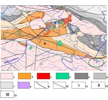
Рicture 4.1 – The location of the plots, which are researched, on the area of coarticulation of Donbass with Priazov'e
1 – granites; 2 – basalts; 3 – trachites; 4 – andesites; 5 – limestones with dolomite; 6 – limestones; 7 – sand-clay slates; 8 – ultramafites; 9 – breaking violations; 10 – prospective breaking violations; 11 – Komsomolsky plot; 12 – Kamishevahsky plot; 13 – Petrovsky plot.
There were studied 218 soil samples by Komsomolsky plot, which were selected by 9 profiles (рiс. 4.2); by Kamishevahsky plot – 1120 samples, which were selected by 52 profiles; by Petrovsky plot – 805 soil samples, which were selected by 26 profiles.
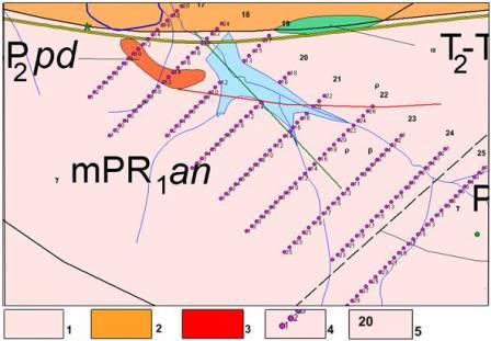
Рicture 4.2 – Sampling scheme on the Komsomolsky plot
1 – granites and migmatites of the proterozoic; 2 – basalts of devon; 3 – trachites of the permian; 4 – the sampling points; 5 – rooms profile; 6 – breaking violations.
In samples were investigated content of the following elements – P, Pb, Ti, W, V, Mn, Ni, Cr, Ge, Co, Bi, Be, Ba, Nb, Mo, Sn, Li, Cu, Zr, Yb, Y, La, Zn, Ag, Sr. The samples were divided into groups on the respective type of the underlying rocks of the studied areas (granites, trachites, basalts, andesites) with using geological map. For each group of samples were calculated descriptive average and maximum values.
The contents of elements in the samples were compared with MAC and regional background with the purpose to estimate ecological safety of soils in the area.
The results of the statistical analysis of samples of Komsomolsky plot soils have revealed marked changes in the characteristics of such elements as P, Ti, Mn, Ni, Cr, Sr depending on the type of the underlying rock (table 4.1). So, the average content of P in the soil less over granites (60*10-3 %) than in trachites (66*10-3 %) and basalts (66*10-3 %).
Table 4.1. The statistical characteristics of elements in soils of the Komsomolsky over the different types of underlying rocks (values of the n*10-3 %).
| Chem. el. | Granites | Basalts | Trachites | ||||||
| Average | Min | Max | Average | Min | Max | Average | Min | Max | |
| P | 64,05 | 25 | 100 | 66 | 50 | 100 | 66 | 50 | 70 |
| Ti | 505,4 | 300 | 1000 | 540 | 300 | 700 | 540 | 300 | 700 |
| Mn | 69,9 | 30 | 150 | 70 | 70 | 70 | 58 | 30 | 70 |
| Ni | 5,3 | 1,5 | 20 | 6,5 | 5 | 15 | 4,6 | 3 | 5 |
| Cr | 8,3 | 3 | 30 | 8,2 | 7 | 10 | 10,4 | 7 | 15 |
| Sr | 7,7 | 7 | 15 | 13,6 | 7 | 50 | 8,2 | 7 | 10 |
The average content of Ti also less in the soils on the granites (500*10-3 %), than on the basalts and trachits. On basalts and trachits this value is 550*10-3%. Values contents of Mn less in the soils on the trachits (58*10-3%) than in the basalts and granites. Their average value is 70*10-3 %. Maximum values of Ni are confined to basalts, where their average value is 7*10-3 %. On trachits its average value is 4,5*10-3 %, and on granites – 5*10-3 %.
Average value of Cr reach large values of in the soils on trachits (10,5*10-3%), basalts and granites are characterized by lower average content of this element (8*10-3%).
The average content of Sr in the soils to be almost twice as high as the content of this element in the soils on trachits and granites
By the results of comparison of the element contents with the regional background and MAC, we can make the following conclusions. Content Ti slightly, but everywhere exceeds the regional background. However, in 10 point of 18 profile there is a double its excess, that may be associated with technogenic pollution of soils. In some places there is a triple excess background such element as Ni. 8 and 11 of point 21 profile are characterized by dual excess of maximum concentration MAC the element. Double excess background in points 19, 21 profile 17 due to the influence of Vasilievsky fault? which is separated basalts from granite. The content of Со everywhere exceed background concentrations. In some places there is a triple and a double excess of MPC such element as Cr, that may also be associated with discontinuous violations and basalts. Excess the regional background is marked also for Сu, Zn, Sr, Ba.
The results of the statistical analysis of samples of Kamishevahsky plot soils have revealed marked changes in the characteristics of such elements as P, Ti, Mn, Sr depending on the type of the underlying rock (table 4.2).
Table 4.2. The statistical characteristics of elements in soils of the Kamishevahsky over the different types of underlying rocks (values of the n*10-3 %).
| Chem. el. | Granites | Basalts | Trachites | Andesites | ||||||||
| Average | Min | Max | Average | Min | Max | Average | Min | Max | Average | Min | Max | |
| P | 67 | 50 | 150 | 75,2 | 50 | 200 | 76,4 | 50 | 150 | 72,9 | 50 | 150 |
| Ti | 515 | 300 | 1000 | 618,9 | 300 | 1000 | 584,5 | 500 | 1000 | 654,4 | 500 | 1500 |
| Mn | 69,5 | 30 | 100 | 71,8 | 30 | 150 | 70,7 | 50 | 100 | 73,1 | 70 | 20 |
| Sr | 7,6 | 2,5 | 10 | 7,5 | 2,5 | 20 | 8,1 | 2,5 | 30 | 9,2 | 7 | 20 |
Minimum values of P are confined to the soils on granites. There its average content is 67*10-3%, while on the andesites, basalts and trachits it is accordingly – 72,9*10-3%, 75,2*10-3%, 74,6*10-3%.
The maximum values Ti observed in soils on the andesites (654*10-3 %), minimum of over granites – 515*10-3 %. The contents of Sr reach their maximum values in soils, which are dedicated to andesites (9,2*10-3 %), over the granites and basalts its average values fall to 7.6*10-3% and 7.5*10-3% respectively. Values of Mn less in the soils on trachits (70,7*10-3 %) and granites (69,5*10-3%), than on basalts and andesites. There are make 71,9*10-3 % и 73,1*10-3 %.
Comparison of concentrations with the regional background and MAC showed the following results. The content in the soils of the Ti exceed regional background on the whole plot, there is a double excess in separate samples. 1-7 sample of 2 profile is characterized by a double excess MAC by such element as V. It can be caused by technogenic contamination of soils. There is also a double excess of this element in the sample no.1 of 51 profile.It can be connected with transition of soils on andesites. By the way, in the same sample P exceeds background in 2 times. Cu и Ba also exceed regional background slightly, but everywhere.
The results of the statistical analysis of samples of Petrovsky plot soils have revealed marked changes in the characteristics of such elements as P, V, Mn, Sr depending on the type of the underlying rock (table 4.3).
Table 4.3. The statistical characteristics of elements in soils of the Petrovsky over the different types of underlying rocks (values of the n*10-3 %).
| Chem. el. | Granites | Basalts | Andesites | ||||||
| Average | Min | Max | Average | Min | Max | Average | Min | Max | |
| P | 71.4 | 50 | 150 | 76.1 | 50 | 300 | 71.1 | 70 | 100 |
| V | 7.7 | 1.5 | 15 | 8.2 | 1.5 | 20 | 10 | 10 | 10 |
| Mn | 69,8 | 20 | 100 | 71.8 | 50 | 100 | 73.1 | 70 | 70 |
| Sr | 8.6 | 7 | 15 | 8.75 | 2.5 | 30 | 9.5 | 7 | 20 |
The maximum values of P are charactered for soils on basalts (76,1 *10-3%), while on granites and andesites they are equal 71,4*10-3 % and 71,1*10-3 %. V, Mn, Sr reach the maximum values of contents in soils over the andesites (10*10-3 %, 73,1*10-3 % и 9,5*10-3 %).
The results of the comparison of concentrations with MAC and regional background are next. P exceeds the regional background everywhere.Double excess of background noted the following points points 20-27 of 19th profile, points 22-31 of 20th profile point, points 5-9 of 25th profil. что может быть It may be due of the influence of basalts on the anomalies of this element. Ti exceeds the regional background in 2 times practically on the whole territory of the land plot (the background for Ti is 482*10-3 %, the content in the samples everywhere is 1000*10-3 %). Ва exceeds the background on the greater part of the site.
Thus, a significant excess of the regional background noted for all plots of the area of coarticulation of Donbass with Priazov'e, which are studied. These elements relate to the first and the second classes of danger, and on this plot are shown agricultural activities. So, their their concentrations are ecological danger.
Comparison the composition of soils and the type of underlying rock showed the following results. Great contents of P, Ti, Cr are timed to trachits. Р, Ti, Mn, Sr, Ni – for basalts; Ti, Sr, Mn, V – for andesites.
4.1 Results of geophysical researches
Shooting by method SGDM-A was held at the Komsomolsky plot. There were passed two profiles : profile no.1 is made in 50 pickets at a step of supervision 5 m; profile no.2 is made in 84 pickets at a step of supervision 10 m.
The results of processing and interpretation of data of the geophysical data revealed the apparent anomaly on the profile 1 in the area of 25-32 pickets, which is reflected the situation of Vasilievsky fault (рiс. 4.3).
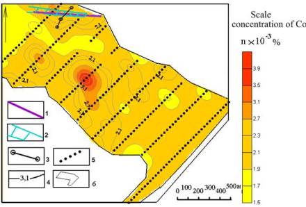
Рicture 4.3. Map of the distribution of Co in the soils at the Komsomolsky plot
1 – Vasilievsky fault; 2 – geodynamic zones according to the SGDM-A; 3 – profile SGDM-A; 4 – lines of the Co concentrations; 5 – points of soil samples; 6 – contour plot of the geochemical survey
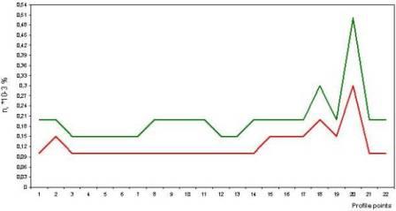
Analysis of the element contents in the limits of the zone of influence of the detected fault showed the following results. A significant excess of maximum concentration LIMIT and the regional background noted for Co (in 2 times), Zn (in 3 times), Ni (in 3 times), Mo (in 2 times), Be (in 1.5 times). The Graphics of change the elements contents in soils within the profile of geochemical survey 17 are presented in pictures 4.4, 4.5. Here is detected a fault also by geophysical method of. Fault zone (Vasilievsky reverse) is shown on figures within pickets 18-20 geochemical profile 17. This site corresponds to the geophysical anomalies СГДК-AND on the profile no.1 (pickets 25-32).
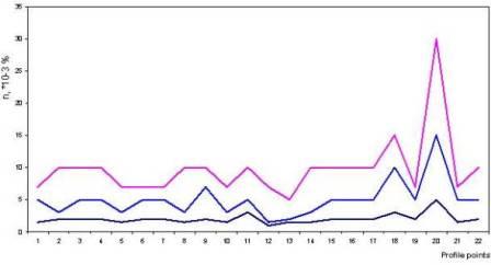
Picture 4.4 – Graphics of element contents on the profile no.17 of Komsomolsky plot
1 – Co; 2 – Zn; 3 – Ni.
Picture 4.5 – Graphics of element contents on the profile no.17 of Komsomolsky plot
1 – Mo; 2 – Be.
Position of the geodynamic zones in terms is shown on picture 4.6. It is accompanied by anomalies of many elements in soils.
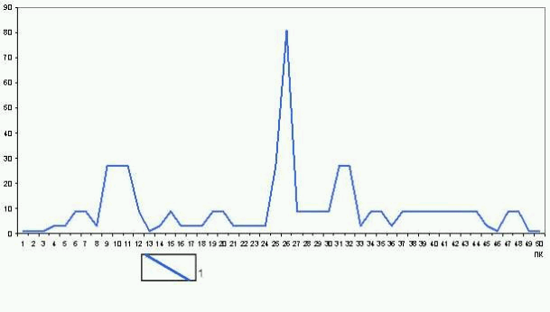
Picture 4.6 – Graphics of SGDM-A indicators on profile no.1 of the Komsomolsky plot
1 – К1; 2 – К2; 3 – К3.
Thus, the conducted researches have shown a trend of accumulation toxic elements within zones of faults and fractures, as well as the impact on the composition of the soil composition of rocks. Basalts and trachites have the greatest influence on the composition of the soil by the most of elements. These factors together with technogenic defines environmentally hazardous the situation in the areas, which are studied. These same factors should be taken into account in the valuation of land agricultural purpose.
1. Алехин В. И., Аноприенко А. Я., Анциферов А. В., Купенко В. И., Панов Б. С., Приходько С. Ю. Геодинамическое картирование: методы и апаратура. – Донецк : ДонНТУ, Технопарк ДонГТУ «Унитех», 2007. – с. 144 с.
2. Алехин В. И. Энергомассоперенос в геодинамических структурах локального уровня и его практическое значение // Проблемы общей и региональной геологии. – Новосибирск: Наука, 1971. – с. 33-36.
3. Алехин В. И. Проницаемость и неотектоническая активность разломов Приазовского блока Украинского щита в связи с оценкой их рудоносности // Наукові праці Донецького державного технічного університету. Серія: гірничо-геологічна. Випуск 45. – Донецьк, ДонДТУ, 2002. – с. 38-44.
4. Нечаев С.В. Минерализация Волновахской зоны разломов. – Киев: Наукова думка, 1970. – с. 172 с.
5. Алехин В. И., Панов Б. С. Структурно-тектонические особенности и минеральный состав нового полиметаллического проявления зоны Южно-Донбасского глубинного разлома // Науковий вісник національного гірничого університету. – № 6. – Днепропетровск, 2005. – с. 12-15.
6. Корчемагин В. А., Дудник В. А., Панов Б. С., Алехин В. И. О связи полей тектонических деформаций и напряжений с рудоносностью в Донбассе // Геофизический журнал. – № 1, т.27. – 2005. – с. 97-109.
7. Пристинская М. В., Койнаш П. В., Алехин В. И. Влияние разломов на формирование экологически опасных аномалий химических элементов в почвах // Охорона навколишнього середовища та раціональне використання природних ресурсів. Зб. доп. 2 міжнар. наук. конф. аспірантів і студентів. – Том 2. – Донецьк, 2003. – С. 117-118.
8. Алехин В. И., Панов Б. С., Койнаш П. В., Коренев В.В. Геохимические особенности почв на карбонатных породах в зоне влияния Южно-Донбасского глубинного разлома // Наук. Праці ДонНТУ. Серія гірничо-геологічна. Вип. 55. – 2003. – с. 120-125.
9. Шеремет Е. М., Волкова К. В., Омельченко А. А. Эколого-геохимические исследования Приазовья с учётом влияния геодинамически активных разломов // Проблеми гірського тиску. Випуск № 12. – Донецьк, ДонНТУ, 2004.–с. 43-53
10. Методические указания к выполнению курсового проекта по дисциплине «Эколого-геохимическая съемка». Составил: В. И. Алехин. – Донецк, ДонНТУ, 2006. – с 22.
11. Алехин В. И., Ребенко Я. В., Шелест К. В. Экологически опасные геодинамические зоны и геофизический метод их выявления // Сучасні тенденції наукової парадигми географічної освіти України/ Зб. наукових статей VI міжвуз. науково-практичн. конф. – Донецьк: ДІСО, 2010. – с. 94-97.