Abstract of master's work
CONTENTS:
INTRODUCTION
Actuality of reserches
Aim and tasks of work
Object and subject of researches
Novelty
The practical value of work
CONTENTS OF MASTER'S WORK
PART I Methodology for determining the zones of influence of anthropogenic sources of groundwater pollution
PART II Characterization of natural and anthropogenic factors in the formation of groundwater
PART III Natural and anthropogenic groundwater hydrogeochemical zoning
PART IV Definition of zones of influence of ash dumps at thermal power plants on ground water
LIST OF LITERATURE
INTRODUCTION
Actuality of reserches
Surface water and the first from the surface aquifer technologically transformed, especially in the industrial area loaded. The abundance of sources of water pollution makes urgent the task of definition and delimitation of zones of influence. Reliable and valid identification of zones of influence can most effectively develop and implement measures to minimize and eliminate adverse impacts. Especially important issues distinguish the zones of influence within the disputed territories, adjacent to each other and are influenced by different sources.
Often there are disputes on whether a focus of pollution, which is located close to or remote from a particular source of pollution. The study of this issue can reliably identify the source of groundwater contamination, to delimit the zone of influence objects pollutants and the chemical composition of groundwater man-made cycles.
This will develop a set of cost-appropriate environmental measures to contain or eliminate pollution. Inaccurate assessment to determine the source of pollution, its boundaries can lead to the development and implementation of unnecessary costly interventions.
Aim and tasks of work
The aim is to identify and distinguish the zones of influence of ash dumps at thermal power plants on ground water with using complex technique. To achieve the goal the following tasks:
- examine existing experience to define and delimitation of zones of influence;
- justify the methodology for the determination and delimitation of zones of influence of ash dumps at thermal power plants underground water;
- explore the mechanism of natural and man-hydrogeochemical zoning;
- explore the inner halo concentration and associative zoning;
- identify and build the halos of pollution;
- on the basis of associative hydrogeochemical zoning to define and delimit the zones of influence of ash dumps.
Object and subject of researches
Object – ash dumps of Zuevskaya , Kurakhovskaya, Uglegorskaya TPP and the surrounding area.
Subject of investigation – the halos of groundwater pollution in zones of influence of ash dumps TPP.
Novelty
The first based on a study of concentration and associative hydrogeochemical zoning defined zones of influence Zuevskaya ash dump, delineated zone of influence within the adjacent areas to the ash dumps of Kurakhovskaya end Uglegorskaya TPP.
The practical value of work
The construction of probabilistic and statistical models of associative hydrogeochemical zoning pollution halos allows to define and delimit the zones of influence of anthropogenic sources of exposure to a certain degree of probability that allows you to avoid developing and implementing effective did not costly. This methodology can be used for comprehensive monitoring of groundwater to predict the development of pollution in the area affected by ash dumps.
CONTENTS OF MASTER'S WORK
The first section is an overview of previous studies to identify and distinguish the zones of influence of man–made objects, estimated state of knowledge of the matter.
About hydrogeochemical zoning – the chemical composition of groundwater in the area – by now an extensive literature.
The first position on the relationship hydrogeochemical zoning with depth and with a change in the mobility of groundwater belongs to Vernadsky, who pointed out the regular change in the crust of fresh water salty and savory – brine. He also pointed to specific changes in the chemical composition of groundwater with depth (increasing the amount of calcium, sodium reduction, replacement of bicarbonate and sulfate chlorine). These changes in the water Vernadsky also linked with a decrease in travel speeds. In this case it was noted that in the deepest parts of the flat synclines produced water almost motionless.
Altovsky said: “It should be borne in mind that there are two types of hydrogeology vertical zonation, one observed by us during drilling, and another – in the fall of aquifers. The first should be called a vertical zoning layers, and the second – a vertical formation, or even reservoir zonation”. Zaitsev and Tolstikhin (1972) identified latitude (geographic) zoning of groundwater, which attributed the changes in the chemical composition of groundwater and the vertical (geological) zoning underground, which attributed the changes in the chemical composition of formation waters.
The dynamics of groundwater as a factor determining the hydrogeochemical zoning in the 30s and 40s indicated in many papers (and Shchegolev Tolstikhin, 1939, Zaitsev, 1940, 1945, Ignatowicz, 1948; Makarenko, 1948, etc.).
The influence of Earth's gravitational field on the distribution of underground water of different composition on the vertical section of the earth's crust has been studied Filatov, Sokolov and Samoilov (1957). They considered the major factors of hydrogeochemical differentiation in the crust, are the physical and chemical properties of elements and the Earth's gravitational field.
Research KV Filatov, D. Sokolov and O. Ya Samoilov showed that top–down in the groundwater under the influence of Earth's gravitational field should have a preferential spread of hydrogen ion, sulfate ion, chlorine, which in general corresponds to the actual location of the anions in the groundwater.
Hydrogeochemical pattern, consisting in the replacement of bicarbonate water sulfate, chloride and then there is not infinite. As always there is a change of natural and human environment [1].
With the use of theoretical concepts and principles of formation of hydrogeochemical zoning currently taking a number of studies to determine the source and nature of contamination, assess the impact of man–made objects.
In 2008, LD has been studied Futoryanskim interaction zoloshlakootvalov TPP and the environment under which they developed criteria for evaluating the geo-environmental hazards accommodation designed ash dumps. Localization of contaminated groundwater is set at a distance of a few hundred meters from the dam [2].
DI Tselyuk studied the characteristics of anthropogenic impact of ash dumps in Central Siberia in the groundwater. They were allocated to migration–active groups of pollutants in the technogenic aquifer working sections of ash dumps, study their behavior in underground aquifers. Contamination of groundwater due to the activity of the elements set geochemical associations: V–Ba–Mn–Pb; Sr–Co–Ni–Cu–Ti; Cr–Mo–Li. The basis for assessment and prediction of anthropogenic impacts on ground water of ash dumps is a comprehensive monitoring system of “ash dump, underground water”, which includes monitoring the processes of formation of man–made geo– and hydrochemical anomalies in an array of ash wastes and their distribution in the groundwater [3].
For a long observation period from 1997 to 2004 in the ash disposal area and the industrial site Uglegorsk TES fixed halo contamination located above an underground stream and runoff influence objects with a set of TPS wide range of elements-pollutants at greater concentrations. To confirm the finding of the existence of two different sources (TPP Uglegorsk and “outside” sources), based on correlation analysis was a comparison of the hydrochemical parameters of surface water and groundwater of the site. Studies have found that the influence of industrial facilities Uglegorsk TPP is negligible compared to the influence of the source, not connected with the activity of TPP. Further investigation showed that this source is regional in nature and is associated with industrial activity s. Gorlovka and Yenakievo [4].
Much of this section is devoted to how to conduct research.
The proposed technique is based on the patterns exhibited by the fact that any anomalous haloes, formed under the action of natural or man-made factors have regular internal structure, which has to a very definite trend of differentiation of matter HS, forming an anomaly.
To identify the source of contamination and determine its zone of influence is necessary to study the internal structure of abnormal patterns of halos and to determine the nature of associative zoning. To this end, the following proposed settlements and the construction of:
- Calculate hydrochemical indices for anions and cations in water samples from each, based on which mapped halo concentration of anions and cations in the ash dump.
- Calculate the estimated parameter of the total pollution multicomponent specific tests – the total concentration index (SEC) and mapped halo contamination [5].
- Generate a sample from the samples, which set a maximum level of pollution at the current level of study, such as high water. The lower limit of the level of pollution is established on the basis of research results. The sample must reach the sample, characterizing the epicenters of the contamination.
- Select the sample between the geochemical spectra are running a significant positive correlation with a confidence level ≥ 0,05 and form a homogeneous sample of them.
- Calculate the average value of the concentration of elements for a homogeneous sample. The resulting average will be characterized by the average statistical parameters of the epicenters of geochemical anomalous zones and will reflect their geochemical range.
- Calculate the correlation coefficients between these geochemical parameters of the epicenters of the average statistical anomalies and geochemical parameters (coefficients of the concentration of elements) of all other samples, including samples of a homogeneous sample.
- The resulting correlation coefficients (R) ranking on the strength and nature of communication taking into account the critical values of R for the confidence levels: ≥ 0,001; ≥ 0,01; ≥ 0,05; ≥ 0,10. In addition, for convenience may be the ranking of samples according to the gradation R: ≥ 0,901; from 0.801 to 0.900, from 0.701 to 0.800, from 0.601 to 0.700, etc.
- Make the obtained values of correlation coefficients on the map and taking into account the grouping of samples on the strength and nature of communication otkartirovat appropriate areas of the halo effect.
- By the nature of the established zoning to determine the boundaries of the zone of influence of the investigated source of contamination and identify abnormal samples, which noted this unusual source of contamination range (association) elements.
There is some difficulty in the study of halos pollution in the aquatic environment, due to the lack of reliably calculated background concentrations of natural waters [6]. In this regard, calculations based on the concentration factor in this case is not possible. Therefore, in determining zones of influence for groundwater and surface water concentrations are allowed, provided that the calculations involved in only trace elements, whose concentration in vivo does not exceed 10 mg/dm³.
This kind of research is needed and most effective in difficult environmental situations, when concentrated in one area more than one source of exposure and their zones of influence conjugate space.
The second section presents the characteristics of natural and anthropogenic factors in the formation of groundwater. The natural conditions and factors include the quantity, quality and chemical composition of precipitation, temperature, wind, geomorphology, topography and geological structure of territory, the hydrological regime of water bodies. Under the human factors in the ongoing investigation means the activities of people, which leads to a change in the geological environment, partial or total, local, regional or global replacement [8].
The results of hydrogeochemical studies suggest that the formation of contaminated groundwater is a man–made metamorphism of natural waters – directional change their chemical composition and properties of the complex under the influence of anthropogenic and natural factors as a result of physical, chemical and biogeochemical processes of transformation and exchange of migratory forms of the ingredients in the system water–rock–sediment.
Tyutyunova distinguishes four sub–continental technogenesis gidrolitosfery. In this case we are interested in subzone I with capacity of 300 m, in the category of man–made effects include exploitation of ground storage of liquid and solid wastes, in our case – TPP ash dumps.
The dimensions of this zone are mainly determined by the maximum total capacity of aquifers and complexes, polluted by infiltration entering the ingredients. The main technogenic geochemical factor in its formation is the infiltration flow of contaminants, which leads to a reduction in reserves of fresh groundwater conditioned [7. 13–15].
Solid and semi-industrial waste, fertilizers and pesticides come in I subband. The exception is solid radioactive wastes that are partially buried in the upper part II of sub-zone. For this zone is characterized by: intense water–groundwater flow and active solutes from wastewater. This means that I subzone subzone is the most profound transformation of the chemical composition of groundwater. They have a high technological degassing of rocks and water. Thus, the main trend of the formation of contaminated groundwater – an increase of mineralization is accompanied by changes in their chemical types [7. 26–32].
The I subband is characterized by the following man-made factors, combined in three groups:
- migrants factors Incoming air: gas content of the atmosphere, the presence of the evaporating surface of liquid waste, and the presence of high concentrations of volatile compounds in industrial waste and chemicals used in agriculture;
- factors of income migrant water: large amounts of industrial waste dumping, high levels of chemicals integrated by agricultural production, high infiltration of waste water from reservoirs, large concentrations of waste production, high level of pollution of surface water supply in areas of aquifers;
- factors changes the hydrodynamic conditions of formation: a high water intake on water intake, use of technology opencast mining of solid mineral deposits associated with the implementation of local and regional drainage of water–bearing rocks; use geotechnological mining methods that violate the natural hydrodynamic regime.
Natural factors of technological metamorphic groundwater consists of the following four groups:
- geological and hydrogeological factors of natural protection of groundwater, power and lithologic and petrographic composition of the rocks of the aeration zone; consistency in the area of regional aquitard, the degree of their facial homogeneity, the ratio of pressures of water horizons involved in the sphere of influence of technogenic;
- climatic factors, supply and addition of ingredients;
- The geological and hydrogeological factors groundwater recharge and income in these ingredients: the position of regional aquitard, their facial consistency and the presence or absence of rocks tectonically weakened zones;
- geological and hydrogeological factors are the ingredients in the migration of aquifer [7. 38–40].
The third section analyzes the processes and conditions of hydrogeochemical zoning.
Geochemical and hydrogeochemical zoning of halos due to a legitimate differentiation of macro– and micronutrients within them [8].
Hydrogeochemical zoning halo seen in the fact that aqueous solutions are in dynamic equilibrium with the contacting epiporodami different zones of substitution. Each zone epigenetic replacement of water correspond to a particular year, that is due to epigenetic bodies there is a definite concentration and hydrogeochemical zoning associative, which also gives an indication of the direction of epigenetic processes, the limits and extent of their exposure. This is most important in solving the definition and delimitation of zones of influence of various anthropogenic sources.
To establish and distinguish hydrogeochemical zoning is necessary to study and analyze the topography, drainage network, hydrogeological conditions, geofiltration scheme areas.
Hydrogeochemical zoning of human nature is formed around the industrialized urban centers and enterprises located separately, eg, thermal power plants.
Hydrogeochemical zoning is manifested mainly anthropogenic change in bicarbonate calcium water with a salinity of 1 g/l sodium sulfate with a salinity up to 4 g/l sodium chloride and then with a salinity of more than 5 g/l. As a rule, the degree of water pollution by toxic trace elements growing in the same direction, especially at low pH.
The main parameters of the human factors are the nature, scale and intensity of impacts on the environment.
The fourth section shows the experimental part, determined by the zone of influence of ash dumps Kurakhovskaya, Uglegorsk and Zuevskaya TPP
On an example consider the structure of TPP Kurakhovskaya doing research.
Factual material to write a master's thesis was selected during the practical training in "Artemovskaya hydrogeological party." In geological engineering in 2009 were carried out to determine the physical–mechanical and filtration properties of soil, forming a dam building sections of the ash dump Kurakhovskaya TPP.
Laboratory studies of water samples were carried out at the Central Laboratory GRGP "Donetskgeologiya" in accordance with the requirements of current regulations and procedures on the instruments that have passed metrological certification.
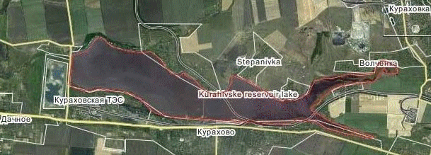
Zoootval Kurakhovskaya TPP in the beam Dry, located 6 km south of the industrial site Kurakhovskaya TPP. In terms of ash–disposal area is rectangular in shape, elongated along the beam Dry from east to west, and adjacent to its right slope. It is used for placement zoloshlakov generated by burning coal–fired thermal power plants Kurakhovskaya. Ash slurry is fed to the ash dump on the system of hydraulic ash. The clarified water is drained into a specially equipped to the west of the ash dump and pond pumping station industrial site is returned to TPS for hydraulic ash recycle. Zoloshlaki practically the whole area of the blade waterlogged.
Dry beam has no permanent watercourse above the ash dump to the east. Depth to groundwater in this part of the bottom beam to the summer low flow is more than 10 meters to the west of the ash dump at the expense of seepage losses from his side of the pond and clarified water there is a constant stream, flowing into the p. Dry Yaly at a distance of 7 km object of study.
Prolonged operation the ash dump, its continuous build up led to the formation of a local manifestation of the dome spreading man–made water. In this case there is a general direction of groundwater movement from the south to the territory of ash dumps and further away to the north to the reservoir and Kurakhovskaya p. Wolf. Narrow band filtration flow from the ash dump is directed to the west along the beam dry. In the zone of influence of ash disposal area to control the hydrodynamic and hydrochemical regime of groundwater in 2003 was equipped with a local network of observation wells. Around the ash disposal area are farmland, within which are actively maintained irrigation and agro-chemical work. Monitoring of the negative impact of this activity is not carried out.
Throughout the period of regular observations, since 2003, in the zone of influence of the ash dump in the 200 m to the north of it in three observation wells are constantly observed an extremely high-water pollution released in a northerly direction for a distance of 1.5 km. All this time, as the sole source of groundwater contamination was considered Kurakhovskaya ash dump TPP. Therefore, to eliminate its impact on ground water adjacent farmland was assumed to be the most effective actions an organization of concrete barrier to seepage from the ash dump on the type of wall in the ground. The preliminary cost of these works was estimated at tens of millions UAH.
As a result of investigations it was found that the Pleistocene and Neogene horizons of groundwater are between a direct hydraulic connection, are fed by waters of man-made horizon ash disposal area, and their primary structure has no effect on the established human–induced hydrogeochemical zoning.
Within the study area is clearly defined hot spots, located north of the ash disposal area (pic. 1). This sets the high salinity (over 20 g/dm³) and chloride–sodium composition of water, the acid reaction of the aquatic environment with a pH of 4,1. In the midst of pollution is established MPC for iron, manganese, nickel, vanadium, cadmium, mercury and other components. As part of the epicenter is regular change of the hydrochemical composition of water by sulfate-chloride, chloride-sulfate to the sulfate and bicarbonate-sulfate. As the distance from the epicenter of the role of calcium, a decrease in the level of mineralization and the total pollution, water become neutral (pH about 7.5).
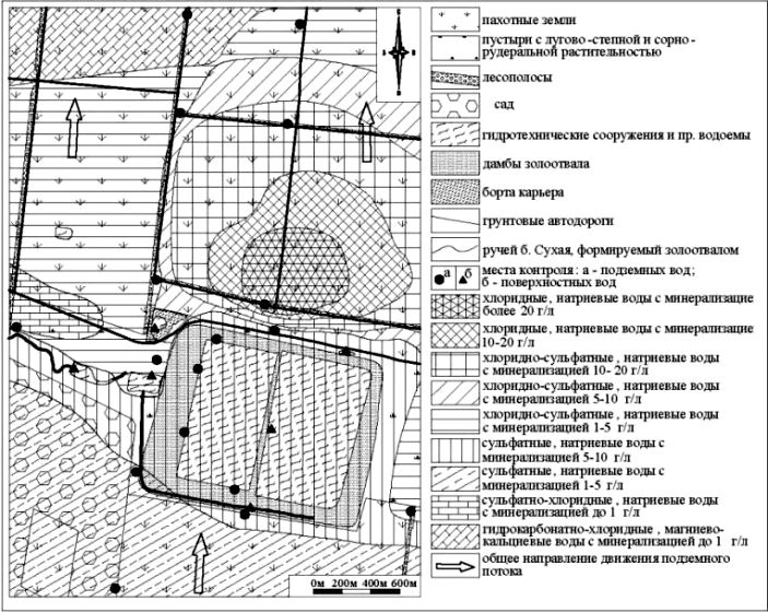
Picture - 1 Hydrochemical zoning district map of the ash dump Kurakhovskaya TPP.
At the same time the ash water seepage from the ash disposal area have a relatively low mineral content to 4g/dm³ corresponding to the background composition Kurakhovskaya reservoir, sulfate, calcium-sodium composition and slightly alkaline (pH 8–8.5). The dome of water spreading man-made in a northerly direction allowed them to track changes in the composition as it approaches the seepage to the established sources of pollution. Have been allocated water of intermediate composition and established the imposition of cleaner technological ash dump seepage water on hot spots. Already at this stage of the study found no association of ash water ash dump and sodium chloride water hot spots, which provided a basis to refuse the design and construction of concrete barrier [9].
Finally, the influence of the ash dump area has been identified and separated from the aura of intense pollution in the study of associative hydrogeochemical zoning on the basis of correlation analysis (table 1).
Table 1 Comparison of the geochemical spectra based on correlation coefficient
| № sample |
Mn |
Fe |
Cd |
Pb |
As |
Hg |
V |
Zn |
Ni |
Cr |
Ag |
Co |
Mo |
R, s.3 |
R, w.3 |
| S 1 |
0,01 |
1,3 |
0,001 |
0,0087 |
0,08 |
0,000276 |
0,039 |
0,020 |
0,039 |
0,059 |
0,004 |
0,010 |
0,003 |
0,311 |
0,899 |
| S 2 |
0,012 |
0,05 |
0,0019 |
0,0005 |
0,01 |
0,000286 |
0,036 |
0,018 |
0,054 |
0,036 |
0,004 |
0,009 |
0,005 |
0,642 |
0,242 |
| S 3 |
0,033 |
0,05 |
0,0009 |
0,012 |
0,08 |
0,000277 |
0,026 |
0,018 |
0,037 |
0,055 |
0,004 |
0,009 |
0,003 |
1,00 |
0,239 |
| S 4 |
0,03 |
0,05 |
0,0023 |
0,012 |
0,06 |
0,000379 |
0,038 |
0,019 |
0,038 |
0,057 |
0,006 |
0,009 |
0,003 |
0,947 |
0,211 |
| S 5 |
0,0005 |
0,05 |
0,0013 |
0,002 |
0,003 |
0,000526 |
0,058 |
0,029 |
0,058 |
0,058 |
0,006 |
0,015 |
0,006 |
0,558 |
0,024 |
| W 1 |
0,85 |
0,6 |
0,001 |
0,002 |
0,0005 |
0,000211 |
0,018 |
0,018 |
0,035 |
0,053 |
0,004 |
0,009 |
0,002 |
0,241 |
0,838 |
| W 3 |
60,4 |
135,1 |
0,004 |
0,01 |
0,0005 |
0,001471 |
0,172 |
0,123 |
0,245 |
0,245 |
0,025 |
0,061 |
0,012 |
0,239 |
1,00 |
| W 4 |
11,00 |
147,1 |
0,0028 |
0,037 |
0,0005 |
0,001026 |
0,072 |
0,051 |
0,154 |
0,103 |
0,010 |
0,026 |
0,005 |
0,237 |
0,937 |
| W 6 |
0,06 |
2,5 |
0,0014 |
0,0036 |
0,0005 |
0,000584 |
0,039 |
0,019 |
0,039 |
0,058 |
0,004 |
0,01 |
0,003 |
0,253 |
0,914 |
| W 7 |
13,80 |
150,00 |
0,0025 |
0,0085 |
0,0005 |
0,000415 |
0,042 |
0,021 |
0,042 |
0,042 |
0,004 |
0,01 |
0,002 |
0,237 |
0,943 |
| W 9 |
0,1 |
1,3 |
0,0013 |
0,004 |
0,0005 |
0,000029 |
0,003 |
0,001 |
0,003 |
0,006 |
0,0004 |
0,001 |
0,000 |
0,239 |
0,938 |
| W 10 |
0,05 |
0,1 |
0,001 |
0,0005 |
0,0005 |
0,00007 |
0,006 |
0,004 |
0,012 |
0,012 |
0,001 |
0,002 |
0,000 |
0,337 |
0,981 |
| W 12 |
0,0005 |
0,7 |
0,0018 |
0,0014 |
0,0005 |
0,000419 |
0,056 |
0,028 |
0,056 |
0,056 |
0,006 |
0,014 |
0,004 |
0,305 |
0,881 |
| Gw-2 |
0,0005 |
0,1 |
0,0005 |
0,0005 |
0,0005 |
0,000435 |
0,048 |
0,024 |
0,048 |
0,048 |
0,005 |
0,012 |
0,003 |
0,532 |
0,498 |
| Gw-3 |
0,1 |
0,2 |
0,0014 |
0,0059 |
0,0005 |
0,000429 |
0,043 |
0,021 |
0,064 |
0,043 |
0,006 |
0,011 |
0,003 |
0,445 |
0,887 |
| W 11 |
18,76 |
219,2 |
0,0032 |
0,0064 |
0,0005 |
0,000934 |
0,057 |
0,018 |
0,003 |
0,024 |
0,001 |
0,02 |
0,004 |
0,237 |
0,941 |
Note:
|
- sample distribution of the halo of ash water ash dump, controlled sample 3; |
|
- sample focus of pollution, controlled well 3 |
For a simplified calculation of the correlation analysis was performed on the two obvious areas of influence – the ash dump and the source of contamination to the north. Halo distribution of ash water is controlled by the breakdown of 3, selected from the cup of the ash dump, and the breakdown of the sources of pollution from observation wells 3. Correlation analysis allows us to compare the geochemical spectrum of trace elements in samples taken in the immediate zone of influence of ash disposal area and to evaluate their changes as they move to the side of seepage from it (pic. 2).
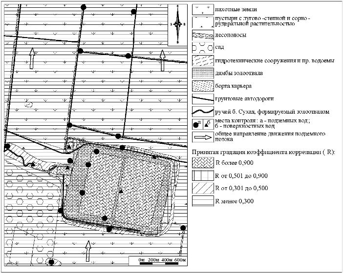
Picture - 2 Map of micro–nutrientsf of associative zoning on the basis of correlation analysis
Mapping the halo of the associative geochemical zoning allowed to establish a regular change of the spectrum of elements with increasing distance from the ash dump. In hydrogeological wells Gw–2 and Gw–3, drilled to the north and south of the ash dump, respectively, on the border of the proposed canopy of ash spreading waters, set a high correlation between the geochemical trace element spectra of ground and mineral waters. However, the power connection is already significantly reduced in the Gw–3 does not reach the limit value for a significance level of 0.05.
In the samples removed from the board of the ash dump at a distance of over 200m meaningful connections with the ash water is not marked. At the same time they established a high correlation with the geochemical spectrum of the source of contamination, which is located to the north side of the ash disposal area (table 1). All these samples are selected from wells located practically on agricultural fields. It was therefore concluded that the source connection of groundwater contamination and the halo formed around him, with the use of chemicals on fields that have well–defined physical and chemical properties and geochemical spectrum, characterized by high concentrations of chloride, sodium and trace elements. In the borehole number 3 recorded abnormally high levels for nearly all analyzed minerals.
As a result of the calculations and map the zoning of the associative data clearly show the diversity of waters by associations of trace elements, which together with other characteristics of hydrogeochemical zoning allowed to determine the lack of communication the focus of intense pollution from ash dumps. Against the background of water adjacent to the ash dumps area of farmland correlation analysis clearly established the zone of influence. She is best manifested within the canopy of spreading the ash water is distributed to a distance of 100–200 m from the side of the ash dump. Only along the creek marked local extension of the zone of influence at a distance of 500 m.
Groundwater within the territories of farmland regardless of the level of mineralization and the total pollution have similar trace element composition. Released by the association of trace elements typical of the epicenter, are distributed over large areas. So intense and quite same type of geochemical range contamination may be due to the processing of agricultural land with chemicals. Sources of pollution to the north of the ash dump is associated with the site preparation of chemicals for use. He currently does not work, still half–ruined buildings. However, the halo formed by the salt in the soil aeration zone and the water-bearing rocks, rich macro-and micronutrients retains its influence, extending in the direction of an underground stream for several miles to the north.
Studies have convincingly demonstrated the lack of communication with the source of pollution activities of the ash dump Kurakhovskaya TPP, which allowed to refuse the implementation of costly and unnecessary in this case, environmental events.
LIST OF LITERATURE
- Гидрогеохимическая зональность. Понятие, развитие представлений, современное состояние вопроса [Электронный ресурс]. – Режим доступа: http://himvoda.ru
- Футорянский Л. Д. Геоэкологические критерии оптимального размещения золошлакоотвалов ТЭС в природных условиях Среднего Урала [Электронный ресурс]. – Режим доступа: http://ursmu.ru
- Целюк Д. И. Особенности техногенного воздействия золоотвалов Средней Сибири на подземные воды [Электронный ресурс]. – Режим доступа: www.vims-geo.ru
- Басанцева М.Е., Выборов С.Г. Принципы определения границ и разграничения зон влияния источников техногенного загрязнения окружающей среды // Cборник докладов IV международной конференции аспирантов и студентов "Охрана окружающей среды и рациональное использование природных ресурсов".- Донецк: ДонНТУ, 2005.
- СанПиН N4630-88. Санитарные правила и нормы охраны поверхностных вод от загрязнения. Утв. МЗ СССР от 04.07.88. – М.,1988.
- Шварцев С. Л., Пиннекер Е. В., Перельман А. И. и др. Основы гидрогеологии. Гидрогеохимия. – Новосибирск: Наука, 1982. – 287 с.
- Тютюнова Ф. И. Гидрогеохимия техногенеза. – М.: Наука, 1997. – 335 с.
- Перельман А.И. Геохимия природных вод. М.: Наука, 1982. 154 с.
- Выборов С.Г., Левадняя Я.Ю., Россеева Ю.Ю. Гидрогеохимическая зональность подземных вод в зоне влияния золоотвала Кураховской ТЭС // VII международная конфренция студентов, аспирантов и молодых ученых «География, геоэкология, геология: опыт научных исследований», Днепропетровск, 2010. 122 – 123 c.
Up