
Abstract
Content
- Introduction
- 1. Background
- 2. Aims and objectives of the study
- 3. Review of legal acts and methodological materials on localities zoning
- 3.1. Legislation that regulates localities zoning
- 3.2. Review of articles and research papers
- 4. Research of localities zoning mapping methods
- 4.1. Zoning Methods based on transport accessibility
- 4.2. Zoning methods based on air pollution
- 4.3. Zoning methods based on noise pollution
- Conclusion
- References
Introduction
Efficient management of land and property set in an urban environment rises need for scientific and practical research in the field of localities zoning. Variety of uses for zoning plans is constantly increasing, including not only the valuation of land zoning, but also property audit and management of residential areas. The results of monetary valuation of urban development factors, such as transportation, ecology, etc. can be used to make additional restrictive guidelines and incentives in land management.
1. Background
Residential areas are complex combination of natural and man‑made landscapes that have different functional and designing qualities, with different level of profitability of land use, which leads to the variety of factors affecting rent in different ways.
This necessitates the need to structure monetary land valuation and economic planning zoning. One of the main factors determining the value of individual parcel of the city is its ecological status. It is assessed based on determining the concentration of a pollutant in the environment and reflects the environmental quality of valuated area. Over the past 10 years, due to the significant increase in traffic, emission from the transport has become a significant part of the overall pollution of urban areas. In Donetsk, for example, emissions from transport have increased by 76 % [1], and scientists estimate that in 2020 gross pollution from transport will exceed that even of industrial emissions. If we do not begin to control this tendency, the ecological situation in the city will adversely affect the health of each resident, leading to a drop in quality and, as a consequence, the price of land. To identify the most problematic areas of a traffic system, we decided to carry out its zoning based on transport accessibility and environmental factors, depending on type of transport, and to use these data for normative monetary valuation and planning of city development.
2. Aims and objectives of the study
Thesis objective: To develop and research localities zoning techniques for monetary valuation.
The main objectives of the study are:
- Analysis of the regulatory requirements for zoning plans creation;
- Improvement of localities zoning techniques for monetary valuation in matters of rational use of urban areas;
- A study on the use of valuation zoning based on factors of transport accessibility, air and noise pollution from road transport in Donetsk.
Research object: is documented information about the urban environment objects.
Research subject: are localities zoning techniques for monetary valuation.
3. Review of legal acts and methodological materials on localities zoning
3.1. Legislation that regulates localities zoning
Nowadays in Ukraine localities zoning techniques for monetary valuation is based on following basic documents: the Land Code of Ukraine, the Law of Ukraine On regulation of urban development
, Law of Ukraine On the Fundamentals of Urban Development
, the Law of Ukraine On the assessment of the land
. There is also a number of other legal documents and guidelines, such as Cabinet of Ministers of Ukraine On the procedure of public hearings to take into account the public interest in the development project planning documentation
, Order of the Ministry of Regional Development of Ukraine On approval of the provision of urban conditions and restrictions on development of land
, their structure and content of the DSTU‑N B B.1.1‑12:2011 Guidance on structure and content of the plan zoning
, in DBN 360‑92** Urban Planning. The planning and development of urban and rural settlements
, DSP 173‑96 Public Health Regulations planning and development of human settlements
, Guidelines for the comprehensive assessment of urban land areas
Kharkov Guidelines for development of zoning schemes cities
MIS 30‑1.99.
3.2. Review of articles and research papers
Over the past 10‑15 years many scientific papers on this topic has been published. Some of the leading scholars such as E. A. Samojlenko, A. I. Ripenko, O. Yemets, O. Melnychuk, A. Ekonomov studied the legal aspects of localities zoning and explored some practical issues: methods to perform and use zoning, and the impact of traffic on the environment of settlements (V. Doroshenko, K. D. Dodsworth, E. M. Matiychyk, M. I. Dolinovska, V. M. Budzyak, Y. M. Palekh, A. V. Svinarov, V. E. Abrakitov, A. V. Vasilyev, D. P. Shevchenko, Y. Y. Dorohyn). Each of them studied zoning methods based on different functional and environmental factors, but each of them considered the impact of the road network on zoning (by environmental factors and by transport accessibility). Group of Russian scientists headed by A. M. Lelyuhina made the most comprehensive study on different zoning methods, the results of this work have been summed up in Guidelines for development of cities zoning schemes
MDS 30‑1.99, used both in Russia and Ukraine.
4. Research of localities zoning mapping methods
4.1. Zoning Methods based on transport accessibility
When it comes to localities zoning, everyone firstly mention accessibility, which is given significant consideration.
Availability expresses the convenience of access to a facility, presents the existing access routes‑roads and infrastructure, the availability of public transport and more. Zoning based on transport accessibility can be expressed in integral index.
V. I. Doroshenko and K. D. Didenko has offered a new integral index – the integrated transport accessibility (ITD) – it is the possibility of reaching any part of the territory with a given speed [3]. Simplified expression of ITD is as follows:
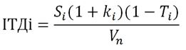
Sі – average (lowest) discounted distance from this point to all other points in the transportation grid;
kі – coefficient of shortest routes variation;
Ті – rate of recurrence in the transport grid for point i;
Vn – regulatory speed on the route.
A. M. Lelyuhina scientist from Russian Federation, offers method of performing a zoning, based on the valuation of scores for contours on cartographic basis formed by the intersection of isochrones (lines of equal time) and score evaluations of transport accessibility zones [4]. Thus three scales are comprised, that determine the dependence of scores distribution based on traffic, pedestrian accessibility and remoteness from the centers of gravity on the condition that the total maximum of score is 10 points.
Figure 1 - Schematic zoning using isochronous
(animation: 5 frames, 5 cycles of repeating, 13,8 kilobytes)
An order of graphical constructs to generate contours estimates obtained by crossing isochronous walking distance lines and distance from the center of gravity (lines are perpendicular routes or lines circles). After the calculation of points on each contour, the entire territory of the city is divided into zones based on the 10‑point scale. There can be 10 or more zones, depending on the distribution of scores in the area [4]. Zones are shown on the cartographic basis in accordance with the symbol indicators.
4.2. Zoning methods based on air pollution
Air pollution from traffic is a result of fuel combustion. Chemical composition of emissions depends on the type and quality of fuel, technology, method of combustion in the engine and its technical condition [2]. Air pollution has a negative impact on human health, the quality and the price of land.
Method of Soviet Union, as described by V.M. Budzyak, was organized by meteorological center, which had a network of observation posts and stations, and in connection with sanitary and epidemiological service observing program was carried out analyzing change in the concentration of pollutants in the atmosphere of cities and towns. The observations were carried out simultaneously in many parts of the town, located in the grid on the distance of 0,2–1,0 km from each other.
As a result of analysis lines with overhead equal concentrations of harmful substances are marked on the map (plan) of the city or town. This method does not account for the impact of weather conditions, but it is the most accurate method at this moment, although this method has two drawbacks: it is expensive and only professional meteorologists using special devices can obtain data for it.
If zoning is made based on air pollution (environmental factor), by method of A. M. Lelyuhinoy, list of sources of pollutants is defined (emissions from motor vehicles), next one needs to determine the criteria for assessing the level of air pollution in the form of excess PDKZ coefficients (5 and 10 times), hazard class ingredients (1, 2, 3, 4), wind rose, emissions per year. Distribution of habitat pollution is calculated by formulas:
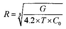
R – radius of contamination km
G – annual emissions of harmful substances in tons per year;
Т – number of days of the company sources a year;
Со – PDKZ this ingredient.
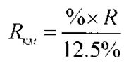
R – radius of the atmosphere (km),
% – the value of the number of wind directions.
Taking center of the source as a start, radii are calculated in the directions of the wind rose, calculating scores, which made up card. Zoning map of the city based on air pollution build a circuit formed by border ranges of harmful contaminants from companies or other sources, taking into account wind rose of the city. Then the contours are also combined in the same area based on a range of points [4].
4.3. Zoning methods based on noise pollution
M. I. Dolinovska, says that physical factor with the greatest impact on the area is the noise generated by vehicles on the major highways that cross the city. Noise pollution is one of the factors which is taken into account recently, but the noise is not less harmful than pollution of air or water.
M. I. Dolinovska offers to estimate an index of ecological status to be performed based on:
- Identification of influence zones of pollution sources;
- Calculating the aggregate scoring of the environment, taking into account the prevailing type of functional use of assessment areas;
- Calculation of indices of environmental quality of area.
This technique can be used for calculation of the level of silence
for 10‑point scale and level of air purity. If you consider only one factor, areas with the same aggregate average score of environmental are grouped. Areas where noise level is significant reduction factor is assigned to K = 0,94.
Another scientist, V. E. Abrakitov, investigated the impact of transport noise on the environment and discovered that there is a dependence of the sound level from the range [7], noise reduction of linear power calculated by the formula:
However, V. E. Abrakitov proposes to measure the sound pressure level with a measuring microphone (sound level meter), which is financially inefficient, but gives accurate results.
Therefore, to measure the sound level we can use the formula of A. V. Vasilyev, who demonstrates that noise depends on the flow of traffic (I, Car/h) and the composition of the stream. Approximately traffic flow noise (dB), depending on traffic (I, Car/h) [5]. The intensity of the noise can be estimated by the formula [6]:
So using the formulas and tendency of sound level reduction, zones with different levels of noise pollution can be defined and its negative effect on the health of the population. In addition, we can reduce the cost of land based on such factor as exceeding the allowable noise levels from vehicles K = 0,94. Alternatively, exterior walls in residential and working premises must sheathed with insulating material thickness of 75 mm and the market value of 350 UAH/m2 wall.
Conclusion
Due to the increasing number of cars, there is also an increase in negative effects on the environment and human health caused by the transport system of the city. In this research, we selected and analyzed rules and regulations in this field. We observed the intensity of transport system of the Kuibyshev region of Donetsk, performed seasonal research, made plan of Kuibyshev region of Donetsk, examined zoning methods in terms of transport accessibility and level of air pollution, and also developed zoning method based on noise pollution. On the ground of this research transport zoning of this area will be performed, which is new for this city.
References
1. Донецкий экологический портал – [Электронный ресурс] – Режим доступа: http://doneco.org.ua/showwork.php?id=8.
2. Оценка стоимости недвижимости; экологический фактор – [Электронный ресурс] – Режим доступа: http://www.bibliotekar.ru/biznes-8/93.htm.
3. В. И. Дорошенко, К. Д. Диденко Основные показатели и индикаторы функционирования пассажирской автотранспортной системы // Вестник Киевского университета. Ср. География. – К., 2005. – Вип.51. – С. 35–36
4. А. М. Лелюхин Учебное пособие Технология оценки городских земель. – М.: «МИИГАиК» – 2000.
. 5. А. В. Васильева Моделирование, расчет и мониторинг шума транспортных потоков – [Электронный ресурс] – Режим доступа: http://www.ssc.smr.ru/media/journals/izvestia/2004/2004_2_399_407.pdf.
6. А. В. Васильев Снижение шума транспортных потоков в условиях современного города // Экология и промышленность России. 2004. № 6.
7. В. Е. Абракитов Картографирование шумового режима центральной части города Киева: монография / В. Е. Абракитов; Харьк. нац. акад. гор. хоз‑ва. – Х.: ХНАГХ, 2012. – 230 с.