
Abstract
Content
- Introduction
- 1. Work urgency
- 2. Technologies shooting land
- 2.1 Measurements of total station
- 2.2 The use of satellite navigation systems
- 3. Choosing Optimal variant of geodetic maintenance of land allocation
- Conclusion
- References
Introduction
Currently, there are new technologies to ensure geodesic survey of the earth's surface. Besides opto-mechanical devices, using the new total stations, satellite navigation systems. For practical use of new techniques and technologies required refresher training, the timing of execution of works and the number of field teams, and others. Despite the high performance, this technique has some features that are certain difficulties in use. For example, the reception of signals of satellite navigation system is difficult to densely built-up area, which complicates the use of this technology.
1. Work urgency
Therefore, these innovations require a feasibility study of the use of technical and technological equipment of production, clear mechanisms of motivation for high performance, resource-saving labor costs, etc. Implementation of technical and economic calculations rather complicated process and automation of payments is an important task that improves the performance of engineering work that requires the use of GIS technology [1].
The purpose and objectives of the study: automate technical and economic calculations to identify optimal use of state of the art and technology of geodetic maintenance of land survey.
In order to identify the most optimal use of the art and technology of geodetic support should take the following practical tasks
1. comparing the technical and economic indicators of using state of the art
2. identify the best option to ensure the geodetic survey of the land plot
Object and subject of study. The objects of research are the technical and economic indicators of the art.
The subject of research is the following land surveying techniques:
1. The use of total stations
2. The observation signals the satellite navigation system GPS
2. Technology shooting land
Damage caused by possible errors shall not exceed the cost of providing precision geodetic constructions by which the damage is eliminated. One method of reducing the damage is the use of satellite navigation techniques [2]. But the main problem of this method of geodetic measurements is high density urban areas. In such circumstances, the coordinates of the boundaries of land faces significant interference and have to eliminate additional geodetic measurements. For this condensation point or shooting justification must be raised over the noise and located on the roof of buildings. Then with the help of reverse geodetic coordinates of notches defined thickening "P". The cost of implementation of additional geodetic measurements were also considered in the construction schedule.
2.1 Measurements of total station
Features electronic total station measurements can significantly reduce the time to perform field work [3]. Accounting for shorter working hours can be achieved through reducing the time factor by the formula:
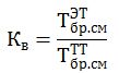
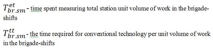
Figure 2.1 – Reducing the time factor
2.2 The use of satellite navigation systems
The use of satellite navigation systems in geodesy chores attracts high productivity. Therefore, the reconnaissance of the subject appropriate to consider the possibility of obtaining the coordinates of points, not only to set the foundations, but also subjects. These points can be vertices corners borders and other objects shooting. The definition of such points should confirm the contours of the specific (Fig. 2.2) and calculate the allowable angle mask obstacles.The figure 2.2. it follows that the main obstacles observation satellite signals are building №5 DonNTU and 2-D and 3-storey house north-west of the intersection. Because use of the advantages of satellite navigation system on the Earth's surface possible.
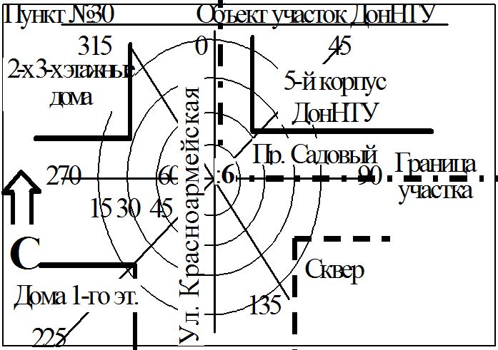
Figure 2.2- Outline the obstacles in the top six border land DonNTU
Densely built condominium site and the area around it and do not allow to observe without distortion signals the satellite navigation system. However rekognostsyrovka it is shown that it may be possible to estimate the coordinates of the vertex angle of 6 boundaries of the site, located at the crossroads pr.Sadovogo and st. Kranoarmeyskoy. Around the top of the foredeck considered (Figure 2 2) Square with trees of medium height, single and three-storey houses and 5th corps of DonNTU.
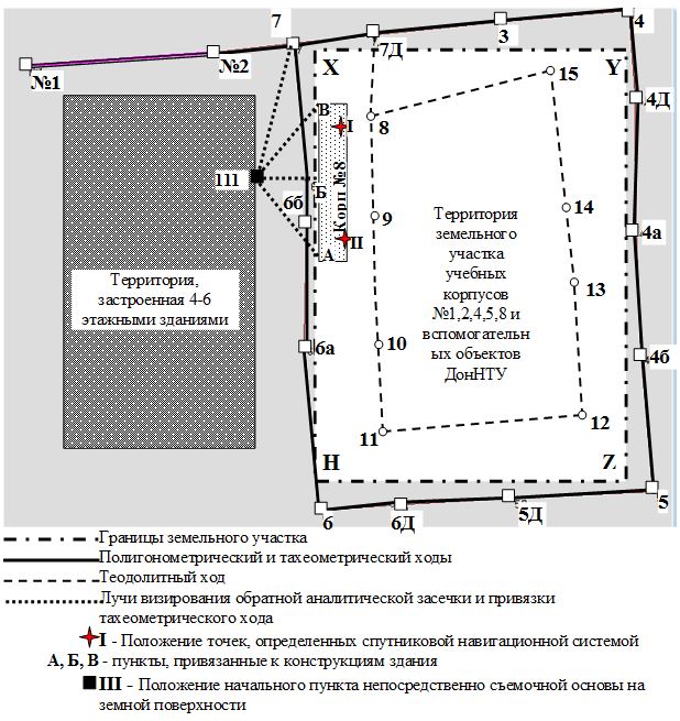
Figure 2.3 - Driving peg of geodetic constructions using satellites -quark navigation system
3. Choosing Optimal variant of geodetic maintenance of land allocation
3.1 Analysis of technical and economic parameters of the project options geodetic maintenance of land allocation
Much of the commercial value of land in the center of the city, as well as the length of the border area and made it necessary to increase the accuracy of determining the position of the boundaries of the land. However, the increase is limited to the cost of accuracy geodetic support.
The balance of losses and expenses necessitated the creation of a basis set of network technology thickening the second category with an accuracy of 1: 5000.
To ensure the accuracy of determining the boundaries of the land at least 1/3000 in a project considered three levels of equipment and technology of geodetic measurements [4]:
1. traditional technology theodolite and EDM T5KP ST-52. measuring total station SET 3030R3 company Sokkia
3. observation satellite signals a GPS receiver GSR2600 while using Total Station SET 3030R3.
Developing options was carried out in accordance with the regulations and technical requirements [5]. The best option suitable for implementation, were selected by a high technical and economic indicators, which are summarized in Table 3.2.
In the basic version adopted first, which are considered the traditional technology of geodetic measurements, which are presented in the regulations governed by the rules of time, costs and prices.
Thus, the results of technical and economic parameters of the project options point to the fact that in geodesy chores use of new technologies support the higher efficiency of new techniques and technologies compared with traditional technologies. The use of these innovations are very useful to society, the state, the collective and directly to each artist.
Geodetic measurements using satellite technology is significantly cheaper than performed by traditional technology [6].
Figure 3.1- Defining coordinate autonomous satellite methods using resection
(animation: 4 frames, 93.7 kilobytes)
А, Б, В – items whose coordinates are determined by a GPS receiver;
Р – start point shooting justification on the ground;
I,II,III– point tacheometric progress;
I,II,III,IV – turning points of land boundaries.
Table 3.2 - Accuracy of geodetic constructions from the damage caused by possible errors in determining the coordinates of turning points of boundaries of the land
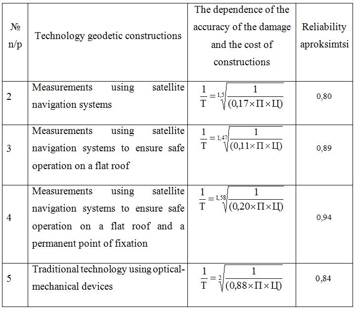
Thus, in a densely built-up areas the use of autonomous satellite techniques, to determine the coordinates of the boundaries of land is much cheaper than using conventional techniques [7]. Even in urban areas and securing a permanent center satellite measurement method is the most economical. The calculation accuracy of the coordinates of land with the specified perimeter and the price per 1 sq m, are shown in Table 3.2. [8]
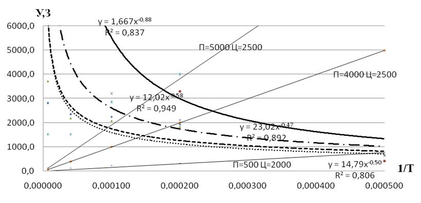
Figure 3.3 - The relationship between the accuracy of determining the coordinates of the boundaries of the land and the damage cost of geodetic constructions
 - the cost of geodetic constructions carried out by traditional technology measuring the cost of GPS-technology
 - measuring the cost of GPS-technology
  - the cost of geodetic measurements made using GPS-technology with a view to ensuring the safety of operations on the roofs of buildings
 - the cost of geodetic measurements carried GPS-technology with a view to ensuring the safety of operations on the roofs of buildings and laying of a permanent center
 - damage from the occurrence of errors in determining the coordinates of boundaries of the land
From Figure 2.2 we can see that the creation of shooting justification traditional methods require cost more than satellite photographic study methods [9]. Damage from the occurrence of errors in the elevation of the lower than conventional technologies. As for the damage affects the accuracy of determining the coordinates of boundaries of the land, and the accuracy of satellite measurements above, it can be argued that this is the best method to use, even in dense urban areas [10].
Conclusion
- The project examined the possibility of the following state of the art technology and geodetic support of land allocation.
- use of electronic total station measurement technology;
- observation satellite navigation system with special receivers in combination with an electronic total station.
- The best recognized as the second embodiment in which the geodetic measurements are carried out electronically Instrument SET 3030R3 company Sokkia.
At this point in the diploma writing process and in connection with this information this essay is not complete and will soon be changed, supplemented and edited.
References
- Современные технологии традиционной геодезии – [Электронный ресурс] – Режим доступа: http://www.geoprofi.ru/default.aspx?id=946&mode=binary
- GPS навигация и геодезическое оборудование мировых производителей. – [Электронный ресурс] – Режим доступа: http://geoagronavt.com.ua/p16060925-gnss-priemnik-promark.html
- Измерения электронным тахеометром.– [Электронный ресурс] – Режим доступа: http://www.newreferat.com/ref-28748-1.html
- Инструкция по топографической съемке в масштабах 1: 5000, 1: 2000, 1: 1000 и 1: 500. (ГКНТА-2.04-02-98). Приказ Главного управления геодезии картографии и кадастра при Кабинете Министров Украины от 9 апреля 1998 N 56. Зарегистрировано в Министерстве 23 июня 1998 г. за N 393/2833
- Ермаков В.С. Инженерная геодезия – [Электронный ресурс] – Режим доступа: http://upload.studwork.org/order/65805/Ermakov_Zagryadskaya_Injenernaya_geodeziya.pdf
- Геодезические измерения с использованием спутниковой технологии.– [Электронный ресурс] – Режим доступа:
http://life-prog.ru/1_35144_sputnikovie-geodezicheskie-izmereniya.html - Использование спутниковых радионавигационных систем в геодезии. .– [Электронный ресурс] – Режим доступа: http://geum.ru/aref/ispolzovanie-sputnikovih-radionavigacionnih-sistem-geodezii-25-00-32-geodeziya-avtoreferat-monografii-na-soiskanie-uchenoy-stepeni-ref.htm
- Сборник цен на изыскательские работы для капитального строительства (СЦ, 1982р)
- Cъемочное обоснование спутниковыми методами.– [Электронный ресурс] – Режим доступа: http://www.blyo.ru/referaty_po_stroitelstvu/kursovaya_rabota_sputnikovye_metody.html
- Координатный метод разбивочных работ с комплексным использованием современных приборов .– [Электронный ресурс] – Режим доступа: http://repo.kstu.kz:8080/xmlui/bitstream/handle/123456789/4336/17%20Хмырова%20Е.Н.%20Тезисы.pdf?sequence=1