Processing and interpritation
source of information: http://www.bngf.ru/eng/wlog_p.html
| Abstract | Library | Task | Results of search | Links |
| DonNTU | Masters DonNTU | Search system of DonNTU |
PROCESSING AND INTERPRETATION
Development of computer geophysical technologies in our Company, including software controlled downhole geophysical equipment, digital recording and respective metrological, methodology and software as well as Internet, high velocity space and land telemetric communication channels created necessary thereon based prerequisites for in principle new system of collection, transmission of technologic and geophysical data. One of this system links is Processing and Interpretation Center (PIC), which performs the key function in all the sketches of geologic geophysical data processing.
Today most of wireline geophysical Departments of JSC "Bashneftegeofizika" are provided with space communications that allowed reaching flexible and efficient interaction of all the links of technologic chain of wireline-geophysical survey not depending on their remoteness.
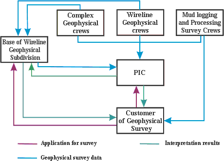
Such organizational scheme allowed enlarging our work geography on the territory of Russia as well as near abroad.
Organization of a common system of wireline and geophysical survey, concentration of methodical and interpretational groups in PIC and their connection with R&P Institutes allows to get our bearings of works almost in any oil and gas deposit, located in any spot of the World and to solve a wide range of tasks most of them are as follows:
There is a wide range of program packages
for processing and interpretation of geophysical survey (GS). The
most effective software package is an integrated system BashGIS. In
the framework of the single data environment processing means of
geophysical survey data in an open hole, well cementing data
processing, development control data processing are combined. 
BahGIS system is constructed on the basis of known system Prime of Bashkir State University in Ufa city. Its development was executed during 1999-2001 in accordance with geological program of Geological Management and Soil Usage Cabinet of the Republic of Bashkortostan and under patronage of JSC "Bashneftegeofizika". Along with Bashkir State University creative collectives of the leading companies such as Bahsnipineft (Ufa), TLP "Geophysica" (Ufa), VNIIGIS (Oktyabrsky), JSC "Tatneftegeophysica" (Bugulma), YuganskNIPIneft branch (Ufa) took part in the system development.
Owing to the usage of this system it's possible to bring together nearly all the interpretation and processing course of the GS data. Usage of the great number of heterogeneous programs is no longer relevant which are as a rule not in accord with data format. Moreover most of the old programs worked under the support of MS DOS that didn't let with the greatest efficiency using computational resources of up-to-date computers.
BashGIS system is also used for GS data processing and interpretation for the purpose of their combining with seismic exploration data. With the object of work efficiency increase at GS data interpretation it is planned a further BashGis, Gektor systems development and improvement and their more absolute usage. Great volume of reserves and current data processing for combining them with seismic exploration data is being done in PIC. When searching perspective structures wireline geophysics solves such problems which seismic exploration cannot solve by virtue of its physical basis. According to geological framework of the site under study range of these tasks can be different but mainly comes to rocks separation to lithotypes, lithologic wells break up, pick out of the fluid bearing rock mass with the further quantitative evaluation of their filtering capacity characteristics.
Experience of work in a new circumstance showed that the interpretation and processing system organization of Geophysical wireline operations (GWO) in a single Center enabled to solve the following basic matters effectively:
JSC "Bashneftegeofizika" counts not only on up-to-date technical equipment as well as a greater attention is given to specialists' policy. Along with high-class specialists with a rich experience in this field there is a young staff, graduated from leading Colleges of the country and the Republic.
Flexible thinking of a young generation of geophysicists enables to use an up-to date processing techniques of wireline-geophysical data.