
|

|
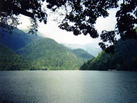
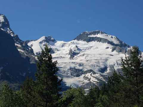
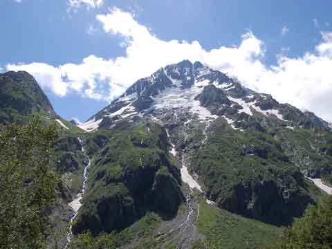
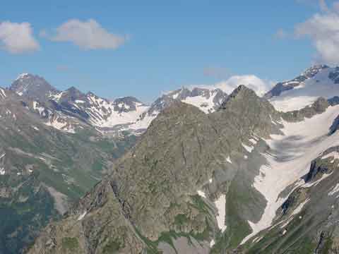
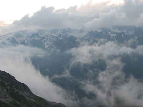
The report on a mountain campaign of the second category of complexity across the Western CaucasusThe Western CaucasusThe Western Caucasus is a part of a range of the Big Caucasus which is located to the west of mountain Elbrus. The part of the Western Caucasus from Anapa to mountain Fisht is made by low and average mountains (Northwest Caucasus), further to the east to Elbrus the range gets the Alpine type with numerous glaciers and high-mountainous forms of a relief. In the tourist literature to the Western Caucasus carry only a part of the Main Caucasian Ridge (MCR) from mountain Fisht to Elbrus. This area belongs to Karachaevo-Circassia (Russia), to Krasnodar Territory (Russia) and republic Abkhazia (Georgia). In territory of the Western Caucasus there is a Caucasian reserve which is under UNESCO protection as the sample of the World heritage. The centre of a range of the Western Caucasus is MCR. A chain of massif in northern spurs MCR, approximately in 20 km from it, name the Advanced (Lateral) ridge. Still to the north, in parallel MCR, the Rocky ridge lasts. To the south from MCR allocate Kodorsky, Abkhazian (Chhaltsky), Bzybsky and Gagrsky ridges. The Western Caucasus is a woody district. Line of MCR in the middle of area reaches wood borders (2000-2200 m above sea level), about mountain Chugush (3240 m) exceed 3000 m, and the higher point reaches in east part (mountain Dombai-Yolgen - 4046 m). Prominent feature of the Western Caucasus is the combination of magnificent woods on valleys and slopes of mountains with high peaks of tops which are covered by snow. Many glaciers here fall almost to wood border. In the stone bowls developed by ancient glaciers there is a set of transparent dark blue and green lakes in a frame of blossoming Alpine meadows, mossy gloomy rocks and taluses. Among them - the well-known lake Ritsa, high-mountainous lakes Kluhorsky, Kardyvach, Mtsra.
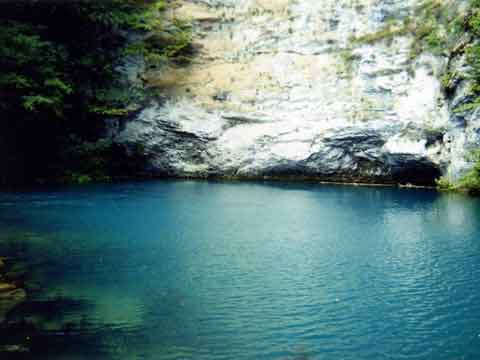
In calcareous ranges (Kodorsky, Bzybsky, Gagrsky, Rocky ridges) various forms of a karst are widely developed: deep precipices, the underground rivers, caves, funnels. On a southern slope there is a set of exits of underground waters: Gegsky falls, Mchisht, Blue lake, Apsta.
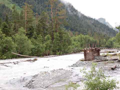
The rivers of northern slope of MCR belong to pool of Kuban which begins from glaciers of Elbrus and in headwaters carries name Uluokam. Largest of them - Uzonkol, Uchkulan, Daut, Teberda, Aksaut, Maruha, Zelenchuk, Big Laba, Small Laba. The basic rivers of a southern slope - Nenskra, Kodor, Chhalta, Bzyb, Mzymta. Water in the rivers is transparent and has a bluish or greenish shade. From all mountain areas of the former USSR the Western Caucasus has the greatest natural contrasts - from glaciers of the Alpine high mountains to subtropics. Feature of a climate - high humidity. The Western Caucasus is the oldest and well mastered area of mountaineering. Here there are routes for beginning travellers and sports groups. The most simple ways lie in a low western part, since Arhyz where through MCR and through its spurs there are many passes 1A and 1B complexity categories (mainly bridge and snow). This area approaches for campaigns I-II of categories of complexity. For east plot of MCR with adjoining spurs (area of Gvandry) passes 1B and 2A categories of complexity of different types (snow, ice, rocky) are characteristic. Here, as well as in Arhyz, there are rich possibilities for carrying out of campaigns of average (to III category) complexities. The main ridge in area Aksauta - Dombai is remote. The majority of passes here concerns to 2A-3A to complexity categories. A North side of passes usually ice, southern - rocky. The southern slope has the big steepness. Here it is possible to organise campaigns IV-V of categories of complexity. Almost on all gorges of the Western Caucasus highways are laid, to the majority of places there is a bus service (from Mineral Waters, Cherkessk, Karachaevsk, Zelenchuksky, Sukhumi, Gadauta, Adler). In upper courses of valleys and on pastures on ridges there are tracks. In mountains of the Western Caucasus it is a lot of monuments of history which are interesting to tourists: Stone Age site; on meadows there are traces of ancient cattle breeding - the rests of shelters, tracks; along ancient trading ways chains of ruins of medieval fortresses and temples of alan time and the period of blossoming Apsilia were stretched; a number of places it is connected with events of the Caucasian War (XIX century) and stay on caucasus outstanding art workers of Russia, passes of the Main ridge store certificates on World War II.
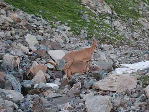
The western part of the Big Caucasus has the big variety of flora and fauna. The considerable quantity of rare species of plants and animals is concentrated to this territory. A little changed inhabitancy of a bison, the caucasian red deer, round, a chamois, the caucasian subspecies of a brown bear, a wolf and other large mammals here has remained. The Caucasian reserve is unique in the world a place of dwelling of a mountain bison, outside of this territory it almost is completely exterminated by poachers. The Western Caucasus is allocated with bright expressiveness of high-rise belts (coniferous woods, mountain meadows). Woods occupy here not less than 60 % of the area. It is a beech, an oak, a maple, a hornbeam, a chestnut, a fir, a fur-tree and other breeds. In total in local flora it is noted more than 3 thousand kinds of which half is made by vascular plants, and every tenth of them is a relict of former epoch. In reserved territory it is noted about 250 kinds of birds, including rare predators nesting here. In territory of the Western Caucasus it is fixed more than 6 thousand kinds of plants and animals. Thus many kinds are recognised by rare and disappearing and some are brought in the Red Book of Russia, and in the International Red Book. ArhyzThe settlement Arhyz is in a southwest part of Karachaevo-Circassian republic, in 52 km to the south from town Zelenchuksky to which it is connected by the asphalted road. In Soviet times this area was Mecca for mountain tourists and beginning climbers. It was promoted by such factors, as easy access to transport sense, simple routes, beauty and a variety of landscapes. "Ariu kyz" in translated from karachaevsk means - the beautiful girl. If to tell more precisely - gorge of beautiful girls. There are some more versions of decoding of this word. On old cards sources of the river Big Zelenchuk named "Irkiz", that is close to Turkic names of the rivers - Irgyz is in the Volga region and in Kazakhstan. The settlement is located in a wide intermountain hollow at height of 1450-1500 metres. Here from cold waters of the mountain rivers Kizgych, Psysh, Sofia and Arhyz is formed Big Zelenchuk with surprisingly pure blue-green water.
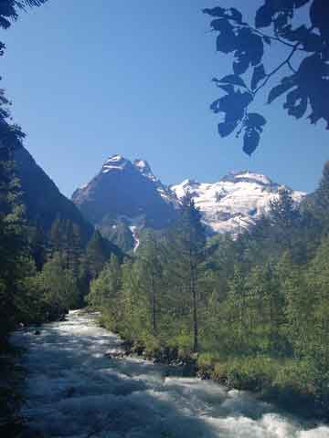
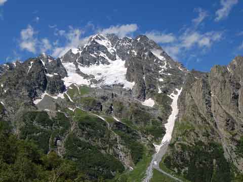
The small settlement based here in 1922 has received the name "Old dwelling", but it has not taken root and some years after settlement began to name Arhyz. Later this name was fixed to the whole mountain area which has become nowadays by serious "contender" of such glorified tourist centres, as Teberda and Dombai. Area of Arhyz are northern slopes of the Main Caucasian ridge. The area is stretched from a river Laba valley in the west to the Maruhsky mountain ridge in the east. From here it is close to Black sea, as the crow flies to it - 70 kilometres. From the south the Main Caucasian ridge towers. It's height here reaches almost four kilometres. The higher point of Arhyz - mountain Psysh (3790 m). There is in this mountain area one more beautiful mountain Sofia (3637 m).
All 60 glaciers in Arhyz are on the Main and Sofia ridges above 2700 metres. Climate of Arhyz is softer, than in the next valleys. Ridge Abishira-Ahuba, high (3000 m) a barrier having fenced off the top part of a valley Big Zelenchuk from the north, has closed there access to cold winds. The wide valley developed on a meridian is well shined with the sun (sunny days 280). Summer in Arhyz not roast. In settlement vicinities daily average temperature of July and August +15,3°C (in the afternoon to +25°C). Winter soft, multisnow. Average temperature in January -5,4°C. The autumn, as a rule, dry, heat costs till November. The area is strongly dismembered by a dense system of the rivers and anonymous streams. The main river is Big Zelenchuk, which extent about 170 kilometres (from merge of the rivers Psysh and Arhyz to a confluence of the river Kuban). The inflow most abounding in water Big Zelenchuk is Psysh with the inflows: Sofia, Amanauz, White, Kyzyl-Sou, Koshevaya. Into the river Arhyz run Rechepsta, Dukka. In Dukka the rivers Small Dukka and the Temir-Kulak run. In Kizgych run Small Kizgych, a Bugoj-Chat, Chigordali and others.
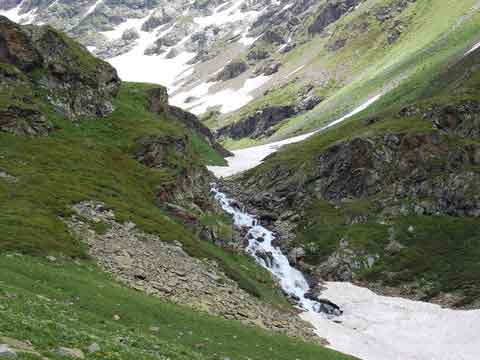
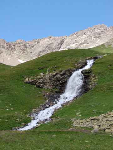
Vegetation of Arhyz is very various. Here is more than 140 kinds wood breeds. In wood of Arhyz the pine prevails. Harmonous and tall trees give to all surrounding a strict kind and sedateness. In upper courses of Kizgych the unique site of old fir wood which amazes with capacity of huge trees and primitive beauty has remained. Firs of Kizgych reach 60 metres of the height, one and a half metres in a grasp, and their age is estimated in many centuries. Separate copies live till 700 years. This site of wood — the rest of those large forests which in the last centuries dominated in the North Caucasus. Wood in Arhyz is valuable gift of the nature. Relic plants of the tertiary period here have remained: the caucasian fir, a fur-tree, a yew and others. Arhyz is one of the most interesting corners of the nature of Caucasus. But this remarkable mountain district is till now little-known for tourists, climbers and mountain skiers. Ak-Ajry passPass Ak-Ajry has a complexity category 1B, the pass height - 3300 m, nature of the pass – snow and rocky. The pass is located in the Sofia ridge and connects valleys of the rivers Ak-Ajry (river Sofia inflow) and Chuchhur (river Kizgych inflow).
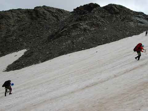
From natural boundary "Glacial farm" in a river Sofia valley we are forwarded on logs on other coast and we start to gain height. A slope not so abrupt. Approximately in 45 minutes of lifting we get out on the following glade. Lifting becomes more difficult. From the big open glade "the mutton foreheads" with falls Ak-Ajry are visible. The track on the right begins, it bypasses "the mutton foreheads" on the right. At first we are forwarded through small inflow, then it is typed about 100 m, we rise on level of falls. The track is divided - the right way conducts to passes Stolichnyy (Bash-Dzhol) and Irkyz, left - in circus Ak-Ajry. Having typed abruptly enough still metres fifty, the track sharply leaves on the left. After that long enough lifting along the dry channel, deducing to Spartakovsky spending the night - a green flat glade about 50 m in diameter follows. From here the track leads up to a talus and is lost. The way is marked by rounds. We rise, getting on a talus of the right board, and we leave in circus Ak-Ajry.
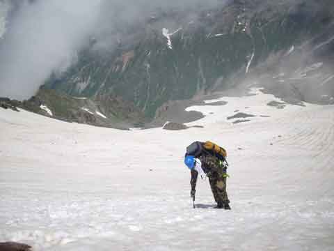
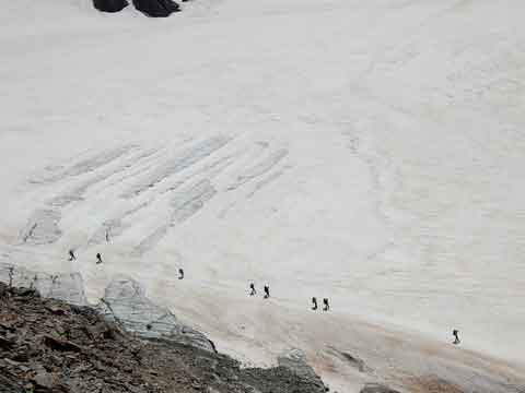
Before lifting is better to go on a glacier - it opened and not broken off. Lifting at first flat (20° packed steady very small talus), then becomes more abruptly, a talus becomes unstable. It is not necessary to rise directly, it is better approximately through 100 m of lifting after increase in a steepness of a slope to leave to the right. We leave on rocks of the right board - so much more safely and more conveniently. On rocks it is typed 100 more metres. Further on last site of lifting it is necessary to come back to a talus. Here it very mobile, conglomeratic type. We leave on a saddle. Lifting occupies approximately 3 hours. Descent faster, but is not easier, as represents the same talus leaving on snowfield and further on the closed glacier. Further still half an hour on a track of the right grassy slope we reach Green lakes where there are good platforms for a lodging for the night. Further descent at first on coast of lakes, further abruptly along a channel of a stream or on it, further on a horizontal site of a valley on a track which goes constantly on the right coast of the river Chuchhur. In the end of a horizontal site on the right the way is partitioned off by a ridge-spur of the right board. The track goes through it with ascent. After descent the light forest zone begins with a ridge, the slope steepness gradually grows. The track is lost by times, the general recommendation - to search for a track in the right part of glades. Last site of descent very heavy. Having got out of wood in grassy thickets of coast of the river Kizgych-Bash, we go downstream, we are wade the river Chuchhur. On very powerful track we go on natural boundary "Devil's Mill" and we leave to river Kizgych flood. Here early in the morning it is possible to wade.
Pass of PoachersPass of Poachers has a complexity category 1A, the pass height - 2890 m, nature of the pass is bridge. The pass is located in ridge Arkasara and connects valleys of the rivers Dukka and the Big Laba. Direct descent to the Big Laba is not present, the track goes down to it's inflow - the river Burnaja. From a river valley the Big Laba we rise on a track along the river Burnaja before parking of shepherds on the right coast of the river (2100 m) where at wood edge spending the night is possible. The track to pass Dukka here departs. Further to river sources Burnaja the footpath conducts. Behind it - plain which when that was a bottom of glacial lake (2200 m). Above the valley is divided into two gorges. Left will deduce to pass Dorbun (1A) and on the river White, to pass Duritsky (1A) and on Amanauz; right - to glacier Vorontsova-Veljaminova and pass of Poachers.
It is necessary to cross plain with the river that more to the right of it's source to get out in gloomy gorge. In the beginning there will be a steep slope on a rocky ledge. In a narrow cut, above - rocks the stream below fights with loops of taluses. Ahead in a rocky range two falls are looked through: pass of Poachers (1A), and more to the right - circus with the glacier named in honour of the known Soviet astronomer which has opened him, a member-correspondent of academy of sciences of the USSR B. A. Vorontsov-Veljaminov, and pass Vorontsova-Veljaminova (1B).
Last part of lifting on pass the most difficult: a slope of pass abrupt (nearby 30°). At first we go directly, crossing of snowfield, on a large unstable talus. Then the track leaves more to the left upwards on smaller talus and deduces on pass (even 2 hours).
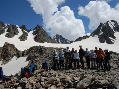
From pass of Poachers (the name it was fixed since those times when from the Big Laba through "secret" pass in gorge Amanauz the poachers hunting on rounds and bears) got the picture opens absolutely unexpected after the passed green valleys. Sharp crests are stuck into the sky, over all dominates Pshysh. From rocks glaciers, snowfields and falls hang down. The silent huge world. Not having risen here, you do not learn about existence such Arhyz. Kinds which are developed on descent from pass, concern the brightest pictures of Arhyz high mountains.
Direct short descent results in the hollow developed by an ancient glacier with lake. The stream which there and then flows down from "the mutton foreheads" follows from lake. Breakage should be bypassed at the left on flat terraces by huge rocky gate through which one of the largest glaciers of area - glacier Amanauz slips. Over its snow fields the saddle of the pass with the same name (2A) is visible. More to the left in a crest peak Amanauz (3530 m) rises. The route passes considerably above a glacier and a stream which is pulled out from under it. The stream will run on a narrow canyon, pass on which is dangerous enough. It is possible to go down to lake at glacier Amanauz on flat mutton foreheads, snowfields and to grassy rocks to the left of lake, however the basic track on the left slope in 1,5 km from pass turns on the left and soon deduces over a spur. Here a fine place for the review (2650 m). On the platforms covered with a dense grass it is possible to settle down and make out river Amanauz gorge conveniently. The mountain Pshysh is looked through all from a sole to top (2 km on a vertical). The track passes through a spur and goes down in the next lateral valley on an abrupt grassy slope. After a niche with lake it is necessary to go a drying up stony channel of a waterway. Below on the bank of a pure stream it is possible to pitch tents (height – 2350 m). Here go down and after passage of pass Duritsky (1A). Descent passes in river Amanauz gorge along a stream. In that place where it breaks from a rocky ledge, it is necessary to pass to the left coast and to go to pines. It is necessary to bypass on the right rocks over a stream further. Descent to a gorge bottom on a crest of an old moraine comes to the end. Fir wood ahead blackens, behind it in easy a smoke the Sofia ridge is stretched. To Psysh there are 2 km. The good track conducts river Amanauz coast in Arhyz (5-7 hours of walking). Vorontsova-Veljaminova passPass of Vorontsova-Veljaminova has a complexity category 1B, the pass height - 3050 m, character – snow and bridge. The pass is located in a spur of ridge Arkasara and connects glaciers Vorontsova-Veljaminova (the river Burnaja, the right inflow of the Big Laba) and Azimba (the river Azimba, the right inflow of the Big Laba). The way to pass on a river valley Burnaja coincides with a route on pass of Poachers. Lifting to pass Vorontsova-Veljaminova from a river valley Burnaja occurs on snowfield (a steepness nearby 25°), blocking the river along a rocky ridge, above a rocky ridge the dinner and spending the night is possible. Further lifting proceeds on rather sloping snowfield with exits of moraines. On last moraines it is necessary to communicate in sheaves. The exit on a rocky file is made on the right on a movement course. Above there are platforms for spending the night and water. Further it is necessary to rise in sheaves on rather sloping (nearby 15°) to a slope to pass. On pass there are some equipped platforms for spending the night.
Phija passThe pass Phija is not category pass in height of 2100 m, character - grassy. The pass is located in a crosspiece between ridges Abishira-Ahuba and Arkasara which is called as ridge Dukka. It connects valleys of the rivers Rechespa (source of river Arhyz) and Phija (the right inflow of the Big Laba). From a farm located in a place of merge Dukka and Rechespa, it is necessary to go directly on road of 4 km to the shepherd's hut. Here it is possible to pass the river on a laying. Roads are not present further, to pass the track conducts. From here to pass 2 hours of walking. It has no characteristic saddle for passes and represents the big alpine meadow stretched on a joint of ridges Abishira-Ahuba and Arkasara. On the right, near to a lonely fir, there is an obelisk. Further the track conducts through a meadow and in 30 minutes leads to descent in a river Phija valley.
Thematic linksK2 Extreme - the information on extreme travel to mountains The description of valleys, passes and alps of the Western Caucasus Club of sports tourism and orientation "Arhar" Tourist club of the Moscow aviation institute |

|
|
|
|
|
|