
1.1 Actuality of theme of work
1.3 The tasks of master's work
Results of directional survey are widely used in arrangement of surveying graphic documentation of exploratory wells.
Preliminary studying of literature established that insufficient and wrong recording of data of wells deviation in graphical construction affect the accuracy of drawings.
Therefore, it is necessary to improve methodology of graphical construction in application of results of directional survey. Results of such work will be applied in development of methodological instructions in order to perform laboratory work in mining geometry.
Aim of work — to get auxiliary materials for the methodical providing of educational process of department.
The concept of thesis lies in provision of present methodology of geometrizing of mineral deposits with additional possibilities.
In the first part of thesis there has been analyzed literature on methodology of processing of results of prospect boring in Donbas.
It is commonly known that coordinates of seam intersection are not fixed directly by geologic exploration as during the drilling and logging only depth is defined, where the well intersects seam floor (so-called axial or shaft depth). In order to find coordinates of seam intersections it is necessary to know position of wells in mineral resources zone. Directional survey is conducted with that purpose. During the survey with survey tool or survey stations in several well points (see Figure 1), which are usually located by the certain interval 1i, the following bedding elements are defined: inclination angle — angle between vertical line and well axis, azimuth — angle between north direction of geographical and magnetic meridian and horizontal projection of well axis.

Results of directional survey of exploratory wells are certainly used in arrangement of surveying graphic documentation.
Processing of survey results is made by several ways. The most popular are the ways, when well is considered as broken curve. At that, there are distinguished several methodologies of finding out coordinates of well points. Let’s consider and analyze their laid concepts.
It is commonly known that exploratory well during the drilling in most cases get incurved or convex deflection (see Figure 1) [1]. Therefore, axial line of each well is three-dimensional curve, type and level of its distortion depends on many factors. Such factors depend on drilling technique and technology and structural and quality properties of redrilled rock mass.
During our analysis of hypsometric plans of Donbas coal seams there have been reviewed seams, where there are exploratory wells drilled in 60th, 80-90th years of the last century and in the first decade of 21st century. Under different factors, which are typical for technological conditions of drilling, as well as mining geology, it is necessary to pay attention to that the drilling depth is deepened: from 200-500 m on the beginning period up to 1100-1300 m — in final examined period. On hypsometric plans in vertical collared wells it is visually observed increase of distance of horizontal location of point of contact with seam relatively to horizontal position of well head. Besides that, it is also noticed big spiral visibility of well, if its position is filled in according to the data of directional survey (sometimes for simplification of horizontal position of the well head and bottom are connected by direct line).
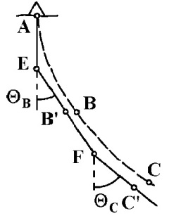
In any case three-dimensional position of well axis is assimilated to openpolygonometric traverse (see Figure 2) with primary hard point, which is exploring opening bottom. The sides of such traverse are the distances between the measuring points of angle units by survey tool. At that, each its side has itsgrid azimuth and inclination angle, obtained according to the data of directional survey.

For sequential computation of increase of coordinates, plane curve of well axis line is substituted by zigzag line. With knowledge of well bottom coordinates Xу YуZу it is possible to compute numeric values of all coordinates by direct surveying of XnYn Zn with general formula [4]:

However, comparing with the first one, the second approach is more approximated to this process, when for each linear interval 1i in formula angle values are substitutional, defined in the beginning and end of each interval [1], [4].


The third to the computation is also possible (see Figure 4). It lies in that angle units defined not for the integral intervals and affect the half of previous interval and half of further interval.
In the result of some transformations we get the following formula:

Formulas of the third method of computations in the literature analyzed by us have not been published; therefore, it is possible to make additional analysis of defining mistakes of points of deflected wells in the development of deposit.
Master’s thesis represents relevant scientific and practical task, which lies in development of methodology of construction of seam surface with application of results of directional survey.
According to the data of research it is possible to make the following conclusions at the present moment.
According to the theory of errors, inaccuracy of directional survey points is computed as average square errors of measures values functions. The accuracy of isolining in projection of seam surface onto horizontal (structural contour diagram) and vertical (isolong diagram) planes in every point of directional survey.
Preliminary computations evidence that the most accurate are diagrams, constructed by the third method. At that, the second and the third methods give close results to each other, and inaccuracy of the first method exceeds inaccuracy of two others several times.
At writing of this abstract work is not yet completed. Final completion — December, 2011. Complete text of work and materials on the topic can be got for an author or for a leader after the named date.