
Determination of the distribution patterns of qualitative indicators of mineral resources, especially non-metallic minerals, is a very important issue. Limestone is used for several industries, depending on quality. Depending on the conditions of the deposit, changing the chemical composition and content of the limiting components are allocated different grades of raw materials. Identify dependencies distribution of quality indicators, as well as the construction of high-grade plans in accordance with individual industries is very important.
Theme of master's work corresponds to the priority area of research "Mathematical Modeling and Methods of Computer Mathematics", a specific PWS. Work is performed at the request of industrial organization, which was held master practice.
Substantiate the patterns of spatial distribution of quality limestone with genetic factors forming deposits
Consider the theoretical conditions for the formation of deposits
A review of the spatial distribution of deposits of limestone and conditions of their formation
Identify the main factors determining the quality of the raw materials of individual deposits, as well as homogeneous blocks of quality in one field
Obtain the statistical characteristics of quality limestone southeastern Elenovskogo field
To map the distribution of quality classes for different industries in the south-eastern part of the deposit Elenovskogo
A detailed examination of the geological conditions, tectonics, and chemical composition of raw materials would justify the relationship of geological factors to the quality of raw materials within the field
Object - the south-eastern part of Elenovskogo deposits of limestone. Item - modeling and forecasting the quality of mineral raw materials
The result of the work will be projected varietal distribution maps of the quality of limestone to be used in production, as well as the pattern of distribution of quality, depending on the genetic characteristics of the formation of deposits
The result of the planned publication of a (paper) and deliver a presentation at the conference
An analysis of literature and library materials on the topic of carbonaceous raw materials in Ukraine and abroad. Particular attention was paid to the Lower Carboniferous deposits of limestone at the junction between Priazovsky megablock Ukrainian Shield and the folded Donbas.
In Ukraine, the study of sediments of the Lower Carboniferous Donets Basin was near geologists since the middle of the XIX century. In particular, the company OP in 1928 - 1929 years. produced by geological mapping of the South-western part of the Donbas, as a result kotorgo adopted a new indexing stratigraphic zones. Ukrgeoltrestom MSK done Geological Survey 1:100000 scale in order to clarify future directions of exploration capacity of balance reserves of flux limestone and dolomite. In 1972-1978. Azov GRE trust "Artemgeologiya was conducted detailed exploration site" Eastern Mine "to a depth of ± 0 m with the calculation of reserves on 01.01.1978, resulting from the detailed exploration in 1976 by the Institute" Yuzhgiproruda were developed permanent condition for calculation of reserves of carbonate raw materials of the site and approved by the SRC.
Study of geological and tectonic features of occurrence of carbonate material in the junction zone Priazovsky megablock Ukrainian Shield and the folded Donbas by scientists, AI Nedoshovenko. In his article "On the method of exploration of carbonate resources southwestern part of the Donbass," published in 1977, illuminated the problem of karst study area and the imperfection of the geological exploration of similar sites.
In AV Kanunnikov and VI Talkers "Lithological features postsedimentary changes and pore space mid-Lower Carboniferous limestones" (1977), the study of carbonate rocks were conducted to evaluate the reservoir, which is widely used in finding oil and gas.
In VA Mikhailova, NN Kurylo, NJ Galkina, "Defining the relationship between profitability of mining companies and technical-economic characteristics of domestic deposits flux of carbonate material" (2005) examined the problem of providing high-quality carbonate raw steel production due to the increased technical demands of industry to the quality of limestone.
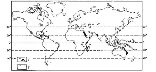
Predominant part of the carbonate sedimentation, although not all completely the result of chemical and biochemical processes in a particular marine environment, which is characterized by clear warm water and shallow water. Feyrbridzh leading figure (Pic. 1.1), which on a global scale shows a clear link of such sedimentation to the equatorial zones and areas of warm ocean currents. It shows that neritovye carbonate sediments are located to the north and south of the equator below latitude 30 °. Between the 40 th parallel of south and north latitude at the bottom of the deep ocean basins is a large amount of carbonate material, but at higher latitudes, it is not, except in the North Atlantic along the Gulf Stream. In the warm clear waters deposited the thickest shells of invertebrates calcite or aragonite composition, there grows a large portion of calcareous algae. It is true that in colder waters inhabited by a huge number of invertebrates, from shells or shells that can blister silty sand but other types of carbonate sediments, such as oolitic, lumpy, pelitomorphic, reef limestone and carbonate muds are restricted in their distribution in tropical and subtropical zone.
However, by themselves the tropical waters are not a sufficient condition for the formation of carbonate sediments. Water should be transparent. Large carbonate banks along the shores of the Gulf of Mexico are located in areas most protected from the main tributary of fine clastic sediments. Last stretch far to the south-east of the stretch in a westerly direction along the removal of clay particles p. Mississippi, and separated from the deep clay-silt material coming from large islands of Cuba. The opposite of the situation on the shelf of the South China Sea to the north of Indonesia, where the vast flat sill - the equatorial shallow water bears only isolated reef accumulations along the northern and eastern edges since major rivers in Sumatra, Java and Kalimantan in the south and west endure a thin slurry in the sea and thereby prevent the formation of carbonate sediments. Feyrbridzh indicates that almost all the shallow shelves in a strictly limited equatorial region karbonatoobrazovanie suppressed thin terrigenous removal of large tropical rivers.
In Ukraine, the largest deposits of limestone are concentrated in the Donbass and the Crimea. This is due to the geological history of the region.
The question arises if any of the marine environment and which specific chemical and biological factors controlling the formation of abundant carbonate deposits? Currently, tropical seas can be considered almost reached the saturation of CaC03. Therefore, any process that leads to the removal of C02 from the normal water (pH 8.4), transforms the bicarbonate ion in monokarbonatny and promotes precipitation of CaC03. As a minimum, this process may be involved the following factors: fever, intense evaporation, the inflow of supersaturated water in areas where there are seeds of CaCO3 or catalysts, the rise of seawater from high pressure to low, mix water, rich in C03 and poor Ca2 + with sea water, organic processes in fluids of a living organism, an expansion involving the bacteria, giving ammonia, an increase in pH and increase the concentration of carbonate and removal of C02 in the process of photosynthesis.
Elenovskoe deposit fluxing limestone and dolomite is located in south-western part of the Donets Basin. Confined to the strip exits the Lower Carboniferous rocks, stretching from east to west from a. Razdolnoye through with. Steele was Dokuchayevsk, pp. Novotroitskoye up with Olginka.
Land Orient Mine is a column of limestone turneyskogo and Visean Lower Carboniferous, occurring relatively quiet. From the north-west and south-east area bounded disturbances relief character. Hence, the area forms a sort of horst bounded by sub-standard thickness of limestone and marl age S1vd, S1ve, S1vf. As established by many years of experience in exploration and production activities in the fields of carbonate material in the southwestern part of the Donbass, Karst and sub-standard layer of rocks in the interior of the mineral are distributed quite irregularly and can not be geometrized in space. This provision is equally true of the species and varietal composition of carbonate raw materials, the regulated condition.
A significant manifestation of tectonic processes in the field led to the widespread development of the fracturing of Lower Carboniferous rocks. Most of the cracks has completed and serves as a major channel for underground water, which contributes to the wide development of karst processes.
The conditioned carbonate rock mass site "Eastern Mine" presented fluxing limestone and dolomite.
The body of minerals in the area "East mine consists of several layers of carbonate rocks, which are gently immersed in a northeasterly direction at angles of 12.8 degrees. Thickness of certified raw material has a complex hypsometric surface resulting from the process of karst formation of carbonate rocks, as well as mine workings, which dissected the body in most of the area.
To obtain accurate information about the causes and patterns of variability in the quality of the limestone, it is necessary to carry out space-statistical study of data southeastern Elenovskogo field. These are spatially linked the chemical analysis of samples of plastoperesecheniyam exploration wells. The sample includes data sampling 35 wells (1427 sectional samples, the average section length 2,0 m). To study the spatial variability of the quality you need to: - Verification of compliance with the quantitative indicators of quality limestone southeastern Elenovskogo deposit requirements of industry; - Analysis of spatial variability in order to determine their zavisimoti from genetic factors; - Mapping the complex refractive index; - Allocation of varieties of limestone for various industries on the map of the complex refractive index. Analysis of quantitative data quality limestone includes the determination of compliance with the requirements of the studied parameters razlichnyz industries. shows the extent to which changing the value of a recognized ¬ ka accompanied by changes in the value of another feature in the data ¬ Noah sample. Correlation coefficient values vary in the range le from -1 to 1. The extremity of this interval indicate a functional linear dependence symptoms, zero - there is no statistical relationship. The calculation of the correlation coefficient revealed that within the studied deposits between indicators of CaO and MgO there is significant inverse correlation (Kk = -0.803). This suggests that in those varieties of limestone, where the content of CaO and MgO high MgO content decreases. This leads to a transition of one type of limestone in the other. Also on the basis of correlations calculated, and the construction of complex quality index, which can significantly increase the reliability of high-grade plans. The most reliable statistics and spatial characteristics of the indicators can be obtained for a homogeneous medium. For this purpose, a statistical study carried out separately by: 1) The entire thickness of the productive field as a whole; 2) separately for each stratigraphic unit; Mean values ??of quality limestone in the whole eastern part of the field are (in weight %): - CaO - 40.33; - MgO - 10,58; - SiO2 - 3,08; - Al2O3 + Fe2O3 - 1,97; - S - 0,06; - P - 0,003. As a result, the experimental data obtained as weighted average quality of stratigraphic horizons. In their comparison revealed that the CaO content increases sharply from the horizon C1tb2, however, significantly reduced the content of MgO, which indicates a change conditions for the formation of limestones: Horizons C1ta1, C1ta2, C1tb1 formed in coastal-marine, lagoonal conditions, with intense evaporation of water and increased salinity, but then changed their deeper zones at the expense of extensive transgression. The highest values of CaO values are set on the horizon C1tb2 (Pic. 1.2), which corresponds to the most quality varieties.

As a result of leaching in the limestones and dolomites Tournaisian and Visean karst cavities were formed.

On the site "Eastern Mine"is the most common form of external karst sinkholes are. The plan they are round. Depth of them - from a few to 60-80 m or even more than 100 m in diameter - from 5-10 to 100 m. The largest karst development reaches the vicinity of faults and especially in the lower parts of the terrain, the beds of gullies and rivers. Internal karst has a very irregularly and uneven distribution of both area and at depth. He is an extremely complex combination of channels, cavities, caves, crevices. These karst cavities in the faces of quarries, as well as data exploration have dimensions horizontally from a few centimeters to 30 m vertically - up to 10 m. Karstic cavities filled with sand and clay materials of different colors. Karst carbonate rocks as separate stratigraphic horizons of the deposit, and the section of "Eastern Mine" varies widely. Inner karst horizons on the site as a percentage is given in Table 1.2
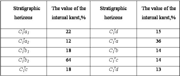
The above table shows that the rock stratigraphic horizons with high silica content less leached, and limestone is chemically purer karst a greater extent.
Based on the study of research on the topic of work, as well as statistical data sampling and its interpretation concludes that the most substantial factors that influenced the spatial distribution of quality. The maps of the distribution of grades of quality, provides practical conclusions and recommendations on improvement of the investigated field.
At the moment, Master's work is in progress. After the December 2011 full text paper can be obtained from the author or supervisor.