undulations using GPS
Resume |Biography
Introduction
Height
Kriging and Kokriging methods
Conclusion
Literature
To date, existing in Ukraine vertical control due to the lack of systematic observations of his methods of precision leveling much out of date. This is due to natural raising and lowering the earth's surface, destruction and violation of settlements as a result of anthropogenic activities. Network recovery by conventional methods is very expensive. All this determines the need for a new, modern methods of determining the altitude of settlements, which are both less expensive and require less time.
To date, the main task of any measurements, including surveying, is to meet three main requirements:
-maximum automation;
-minimum expenditure of material resources and time;
Correspondence required accuracy.
Traditional methods of measurements (measurements using traditional surveying instruments) may not meet all three requirements simultaneously.
At the moment the most rational is the definition of the coordinates of points using GPS-technology.
Consider the benefits:
1) use only one receiver,
2) The uniform accuracy of the measurements;
3) high efficiency of the work;
4) The accuracy meets the requirements of nearly all types of survey work.
The accuracy of geodetic survey in Ukraine are instructions for surveying, by which we can conclude that, in surveying trebuetsyarazlichnaya accuracy, it depends on the type of work performed.
To date, there is a problem of increasing the accuracy of GPS-measurements. Mnogotraektornost, diversity antennas, and other factors make scientists around the world to fight for the elimination of these shortcomings. Because of this, today the satellite method can achieve accuracy of 2.5 cm for the majority of survey work, such accuracy is acceptable. [1]
Speaking of vertical control, one must first understand what we mean by height in geodesy.
height is the point of the plumb line segment from that point to a certain level surface, adopted at the beginning of the report of heights. [3]
As we know, from the GPS-determined ellipsoidal height measurements (see Fig. 1 and Fig. 2). ellipsoidal height some point the physical surface of the earth is called the segment of the normal to the ellipsoid from the surface to the point of the earth's surface, that is a distance from the surface of the ellipsoid along the normal. Ellipsoid , in turn, - a body obtained by rotating an ellipse around its minor axis.
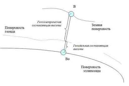
Figure 1 - The Countdown heights
In geodesy using normal height (see Fig. 2).
normal height point - the distance from this point on quasigeoid plumb line. They are used for most geodetic work in the former CIS. Normal heights are listed in directories of geodetic stations and displayed on maps. Can be determined from the results of leveling, as well as calculated by the geodetic heights. [3]
Quasigeoid concept closely related to the concept of the geoid.
geoid is defined as the equipotential surface of gravity of the earth's field (equipotential surface), roughly coinciding with the middle of the World Ocean in an undisturbed state and conditionally extended under the continents. The difference between the actual mean sea level from the geoid can reach 1 m. By definition, an equipotential surface, the geoid surface is perpendicular to the plumb line everywhere. And additional surface, very close to it, and representing the figure of the real Earth - quasi-geoid ( See Figure 2). [3] By the indeterminacy of the shape of the geoid, quasi-geoid serves as a supporting surface for the study of the physical surface of the Earth. His figure, in contrast to the geoid, is uniquely determined by the measurement results coincide with the geoid in the ocean and very close to him on the ground, leaning no more than 2 meters in the high mountains and a few inches on the plains.
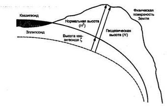
Figure 2 - Height of Geodesy
Countdown to normal heights taken from the zero point of the Kronstadt tide gauge (this system is called a normal system of the Baltic Heights).
It is clear that the normal and ellipsoidal heights do not match.
The difference between the values ??of the ellipsoidal and normal heights is ondulyatsiey .
It is defined by:

h - the height of the ellipsoidal
N-normal height
Necessary to develop a method of accounting ondulyatsy (transition model), allowing the found from observations of GPS-ellipsoidal heights to obtain normal height with maximum accuracy.
In this case, the determination of heights of the GPS-observations can be an alternative to geodetic leveling.
Modelling the transition already exist in the world. In the United States engaged in such developments, Thomas H. Meyer, Daniel R. Roman, David B. Zilkovsky, in Israel, it is I. Tuchin, G.Iven-Tzur, G. Steinberg, and others. In both countries were conducted programs to build high-rise foundation, through which there is no need to determine the height of new and update existing height of the leveling frame with traditional methods
Instead of high-altitude base in a hierarchical GHS was established network of permanent stations. At these stations, as determined by the height of spirit leveling, and there with GPS. The stations are uniformly distributed throughout the country, the data on them are being updated and are free from errors caused by anthropogenic influence. Derived ellipsoidal heights are equal in accuracy. Where a higher accuracy, it is proposed to use the local leveling network by traditional methods. [2]
If there is a system of points at which known quantities of ellipsoidal and normal heights, then by (1), we can find ondulyatsiyu at each point. Imposing on the system of surface points, we obtain a model which will be called ondulyatsionnoy model. If available, using the Kriging interpolation methods and Kokriginga, we can determine the ondulyatsii at each point of the surface.
This surface is a grid of squares, in which the nodes are defined ondulyatsii. The grid can be created with different step, which gives different values ??of the errors in determining ondulyatsy corners of a square. Scientists from Israel tested a grid with steps of 4 km to 4 km, 1 km to 1 km, 0.5 km to 0.5 km, and determined that the optimal grid spacing - 0.5 km to 0.5 km (see Fig. 3), because the accuracy obtained measurement is dependent on the distance between grid points. Ondulyatsionnaya surface in Israel, founded in 684 x 684 base elevations.
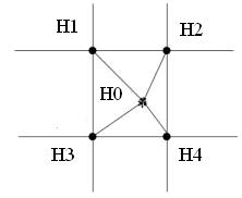
Figure 3 - The interpolation in the square of height
Scientific adviser, Ph.D.: Andolenko Svetlana
Resume |Biography
Absract
Introduction
To date, existing in Ukraine vertical control due to the lack of systematic observations of his methods of precision leveling much out of date. This is due to natural raising and lowering the earth's surface, destruction and violation of settlements as a result of anthropogenic activities. Network recovery by conventional methods is very expensive. All this determines the need for a new, modern methods of determining the altitude of settlements, which are both less expensive and require less time.
To date, the main task of any measurements, including surveying, is to meet three main requirements:
Height
Speaking of vertical control, one must first understand what we mean by height in geodesy.
height is the point of the plumb line segment from that point to a certain level surface, adopted at the beginning of the report of heights. [3]
As we know, from the GPS-determined ellipsoidal height measurements (see Fig. 1 and Fig. 2). ellipsoidal height some point the physical surface of the earth is called the segment of the normal to the ellipsoid from the surface to the point of the earth's surface, that is a distance from the surface of the ellipsoid along the normal. Ellipsoid , in turn, - a body obtained by rotating an ellipse around its minor axis.
Knowing the values of the nodes ondulyatsii square on the constructed model can be defined in any arbitrary ondulyatsii point on the surface. Obtain it as follows:

Kriging method - a method of interpolation, which is based on methods of mathematical statistics. In its implementation applies the idea of ??regionalized variables, ie variable, which varies from place to place with a visible continuity, it can not be simulated by just one mathematical equation. The surface is represented as three independent variables. The first - the trend in change of the surface in a certain direction. Trend (Fig. 4), as is known, is a long-term trend in the test series. It is assumed that there are small deviations from the general trends, such as small peaks and valleys (for example, the peaks and troughs - see Figure 4 and 5), which are random, but still related to each other spatially. Finally, there is random noise (which is presented by the figure is denoted as boulders). Each of the three variables have to operate separately. The trend is estimated using a mathematical equation that best describes the overall change in the surface, much like the surface of the trend. [4]
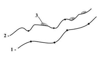
Figure 4 - Elements of Kriging
1 - trend
2 - random, but spatially related to altitude variations,
3 - random noise (boulders).
Kriging method and Kokriginga
Kriging method - a method of interpolation, which is based on methods of mathematical statistics. In its implementation applies the idea of ??regionalized variables, ie variable, which varies from place to place with a visible continuity, it can not be simulated by just one mathematical equation. The surface is represented as three independent variables. The first - the trend in change of the surface in a certain direction. Trend (Fig. 4), as is known, is a long-term trend in the test series. It is assumed that there are small deviations from the general trends, such as small peaks and valleys (for example, the peaks and troughs - see Figure 4 and 5), which are random, but still related to each other spatially. Finally, there is random noise (which is presented by the figure is denoted as boulders). Each of the three variables have to operate separately. The trend is estimated using a mathematical equation that best describes the overall change in the surface, much like the surface of the trend. [4]
Kriging standard deviation is taken as the error model and implemented in the model on the same grid 0.5x 0.5 km as the value ondulyatsy. Carried out many numerical experiments to determine the parameters of variogram.
Kokriging allows us to construct surface maps of several sets of points, which increases the reliability and detail of the results of interpolation. This is required for the implementation of our algorithm is also because the model is constantly expanding, the number of reference points increases, which means adding new data sets. In addition, this feature adds to the method of interpolation of additional data analysis possibilities vzaimokorrelyatsii, and thus more flexibility. That is, the secondary variable is used to predict the primary. [5]
Kriging method is used in software packages
Geostatistical Analyst, Geode, Surfer, ArcView, and others. In this paper we will apply software packages Surfer 8, ArcView 3.1. Software implementation will be carried out in an environment Delphi 7.0.
Conclusion
To solve the problem of mismatch of the ellipsoid and the geoid, and their difference must be calculated for each point the surface, where measured the coordinates. This becomes feasible when the following conditions:
- Good links between the GPS and leveling networks of networks;
- Built an accurate model of the geoid;
- Created the mathematical and software tools to evaluate the difference between ellipsoid and geoid at every point of the surface.
Thus, the main purpose of work - to determine the most efficient method of determining height.
This involves the following tasks:
1) to analyze systems of heights used in a variety of surveying work;
2) to explore methods of satellite measurements in the determination of heights;
3) to study methods for constructing surface models using information technology;
4) examine the theoretical foundations of models and algorithms accounting ondulyatsy;
5) develop a method of accounting ondulyatsy.
Resume |Biography
References
- Gershon Steinberg and Yakov Tuchin "Two Years Experience with the Israeli Official Geoid Undulations Model" //TS 3C - GEOID - Modelling, February 2009.
- Yakov Tuchin, "Development of the Geoid-Ellipsoid Separations Model in Israel" //Shaping the Change XXIII FIG Congress Munich, Germany, October 8-13, 2006
- Geodezіya. Chastina Persha. Vidannya friend, she vipravlene dopovnene. (For zagalnoyu redaktsієyu of professor, Dr. SG Mogilny of professor i Voitenko SP). - Donetsk, 2003 p. - 458 sec.
- Антон Сухинов "Крайгинг интерполяция" [Электронный ресурс] — 2011. Режим доступа http://iproc.ru/drafts/kriging/
- "Координатное пространство" [Электронный ресурс]. — 2010. Режим доступа http://www.metclad.ru/collection/koordinatnoe_prostranstvo/71/
- Силкин К.Ю. Геоинформационная система Golden Software Surfer 8: Учебно-методическое пособие для вузов. — Воронеж: Изд-во ВГУ, 2008. — 66 с.
- Поклад Г.Г. Геодезия: учебное пособие для вузов / Г.Г. Поклад, С.П. Гриднев. — М.: Академический Проект, 2007. — 592 с.
Resume |Biography