|
|
|

The purpose of master's thesis — study of the influence of tectonic structure on the quality of the mineral.
The idea of — comprehensive analysis of the fractured limestone deposit system and its coincidence with the direction of regional stress fields.
Objectives:
The object of study — East-Komsomolsk area Elenovskogo deposits of limestone and dolomite
Subject of study — tectonic processes of minerals
The limestones have a very wide range of applications. Mainly, they are used in the metallurgical industry as a fluxing agent. Introduction of new technological processes in industry require increasing the quality of flux on the chemical composition and mechanical strength. Depletion of high quality raw material producing fields requires detailed study of the tectonics of the area and determine the characteristics of tectonic stress fields to identify their relationship with the distribution of qualitative raw material.
The study of geological conditions and detailed tectonic deposits of limestone will prove relationship of tectonic stress fields with the mechanisms of karstification in limestone, and their vliyayanie on qualitative indicators of raw materials.
This scientific work is connected with national programs of development of mineral resources of Ukraine for the period until 2030 under the heading "New technologies and energy saving technologies in energetike, industry and agriculture." It is conducted on the instructions of "PC DFDK".
Information about the dependence of changes in quality characteristics of limestone from the tectonic structure of the deposit, defining the characteristics of tectonic stress fields and their relationship to the karst formations in the national and international practices have been identified.
In DonNTU information about the development of these patterns of distribution of quality limestone, is not revealed.
Structurally, the district Elenovskogo deposit is located on the southern flank Kalmius - Toretskoy basin. The north wing steep valley, it rests on the main anticline Donets ridge and the southern flatter wing - in the Azov crystalline massif.
Location of the area at the junction of two major structures led to the development of complex plikativnoi and disjunctive tectonics, which resulted in its structure is close to the bloc. The area allocated 3 structural floors. The ground floor is complicated greatly metamorfizovannimy difficult stationed Precambrian rocks, the average - slightly metamorfizirovannimy collected in the folds of Devonian and Carboniferous, upper - horizontally bedded, education, and Cenozoic. Sublatitudinal (280-290) Kalmius - Toretskaya depression caused a general drop in rocks of the north-northeast and north-northwest. Stretching from the west section Olginka up with. Razdolnoye in the east rocks of the Lower Carboniferous and Upper Devonian have a general inclination angle of 6-20. Monocline their occurrence is difficult structures multiplicative nature of higher order and the network dizyunktivnyh violations. With the multiplicative structures are distinguished with respect to lateral stretch of rocks submeridional Novotroitska and Alexandrinsky anticline, syncline separated Dokuchaevsky. Wings of these folds have dip angles of 16-24, and the vaults are divided fairly large number of disjunctive dislocations, where falling rocks reaches 45. However, the main tectonic elements of the district is not multiplicative, and disjoint violations - reset and reverse faults, due to which area is characterized by a complex block structure. Depending on the spatial orientation in the area providing 4 major fault system: sublatitudinal, north-west, submeridialnu and north-east.
The main role in the structural framework Olenevskogo deposits owned by three major faults sublatitudinal. In the northern part of the deposit can be traced north-Volnovakha reset with displacement amplitude up to 50m. Fall of relief in the south-west angle of 70-78. On this violated the Lower turneyskie carbonate rocks are faced with marls vizeyskogo tier / CIve /, and limestone horizons of sand-shale horizon CIvg.
With the zone of crushing North Volnovakha relief through all the field can be traced Volnovakha reset. Plane shear rock falls in the south-west angle of about 650, and the displacement amplitude reaches 100m. In the area between the North and Volnovakha Volnovakha faults are the lot "Beam Water", Central and Eastern part of Komsomolskaya station. Still farther to the south of Volnovakha reset almost parallel to it runs south-Volnovakha reset. Angle of incidence of plane displacement of species ranges from 35 to 70, the direction of the fall of the south, the displacement amplitude reaches 500m. Southeast Volnovakha discharge is accompanied by a strong zone of crushing and hydrothermal alteration. Throughout the relief observed polymetallic mineralization, represented by pyrite, chalcopyrite, sphalerite and galena.
On the East-Komsomolsk site goes through a series of discharges of the second and third orders, which are offshoots of major violations. The amplitude of these discharges is much less than basic. Steep angles of incidence stripper - 60-75. Indicated Dumping site is divided into 5 blocks with a different dip for individual blocks. Rocks in the tectonic blocks crumpled into folds flat / angle wings from 1-3 to 20. The folds are typically characterized by small size, and structure them pretty undisciplined. In general, the field multiplicative disturbances of vital importance not have, but in some areas the presence of folding makes selective mining of carbonate material.
Established that the basic forms of the tectonic structure of the region were created in the Hercynian stage. The next phase took place the same secondary folding.
As a result, the selection of facts were the following measurements: - Measurements of slickensides with the definition of the direction of displacement in East Komsomolsk area - measurements of cracks and their orientation - measured veins and ore-bearing formations.
In the area of the East Komsomolsk area Elenovskogo field measurements were made of mirrors with the definition of slip directions of the displacements. Observation points were located as evenly as possible on the site.
In material processing and interpretation of the results by using computer programs developed in the GIN RAS, Donetsk National Technical University, Institute of Physics of the Earth Sciences and the Moscow Geological Prospecting Academy. Mainly used by a computer program GEOS. Reconstruction fields of tectonic stress and strain are made in accordance with the method of kinematic analysis of fracture-rupture of structures designed by OI Gushchenko [5], Mostrikovym A., Vasilyev NV and others [2,4,10,11]. Baseline data were combined into groups of 20-30 or more discontinuities in accordance with the placement of observation points (points located as evenly as possible on the mine field) for reconstruction in these parameters of the field. Then the data were calculated on the smoothed values \u200b\u200bof the total strain field in each node of the grid according to the mirror slide. Determined by the orientation of the axes of principal normal strains (E1, E2, E3,), their ratio (ratio Lode-Nadai - Meps), as well as the relative value of the vertical component of the strain ellipsoid (z-component).
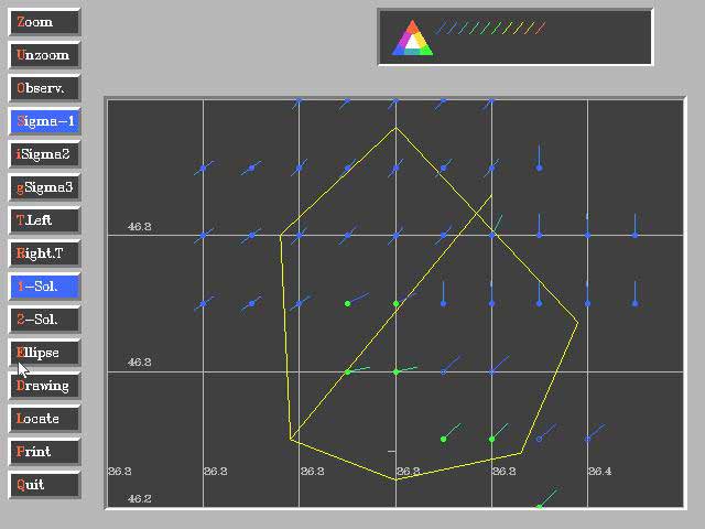
The orientation of the axes of the deformation fields allows us to estimate the direction of tectonic movements. The coefficient Lode-Nadai allowed to determine the distribution of sites of compression and expansion of rock. Z-component of the strain ellipsoid characterizes the relative vertical movement. It should be noted that we consider only the field of the total tectonic deformation, t.e.podrazumevayutsya only brittle deformation (Fig. 1) [7,8].
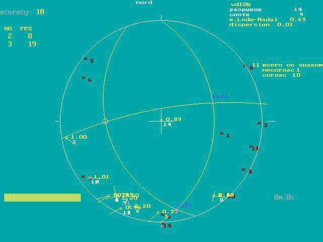
The study and treatment of the factual material were determined orientation of the axes of principal normal strains (E1, E2, E3,), their ratio (ratio Lode-Nadai - Meps), as well as the relative value of the vertical component of the strain ellipsoid (z-component).
The studies yielded new data on the characteristics of the field of total tectonic deformation East Komsomolsk area.
The calculations were obtained values of the Lode-Nadai (Meps) and vertical components of the strain ellipsoid. After matching that on the study site were identified zones are under tension and experiencing uplift surface.
Plots in these conditions simultaneously, may be favorable for the accumulation of ore materials.
In writing this essay master's work is not completed yet. Final completion: December 2011 Full text of the materials on the topic can be obtained from the author or his manager after that date.