Essay on the subject of the master’s thesis
Content
Analysis of the legal framework
Topicality
In 1990 in Ukraine the land reform was started. As a consequence of its implementation, redistribution and subdivision of acres took place, as well as spontaneous formation of multiple agrarian enterprises. It broke all the existing system of the rational land use that led to the deterioration of the land quality. Therefore, it was assigned at the legislative level that each agricultural commodity producer was obliged to carry out the use of agricultural holdings based on developed and approved land utilization projects. However, Ukraine does not have methods of creation of these projects, when developing them are used constituent parts and elements of the farm boundary adjustment, which are based on the outdated norms created for large-scale enterprises more than 20 years ago.
The above-mentioned regulations defined topicality of the implementation of theoretical and methodological research in the sphere of improvement of the project development techniques, particularly improvement of norms that will let to attain the greater economic effect when preserving and improving land quality.
Issues of land utilization project development, which ensure the eco-economic basis of crop rotations and grounds regulation, as well as issues of techniques of farm boundary adjustment projects creation were covered in papers of D.S. Dobryak, V.M. Drugak, A.M. Tretiak, A.G. Martyn, M.P. Stetsyuk, V.P. Volkov and other men of science. However, many issues of theoretical and methodological nature are not covered fully enough and do not let to get a complex idea about projection methods.
Goal and tasks of research
The goal of the master’s thesis is: To develop the technological model for development of land utilization projects, which ensure the eco-economic basis of crop rotations and grounds regulation (hereafter Projects).
To attain the goal following objectives were assigned:
1. To implement analysis of existing legislative ensuring and scientific state of knowledge of creation of Projects for the purpose of revelation of topicality.
2. To summarize theoretical and methodological bases and to substantiate means of further improvement of techniques of development of Projects.
3. To develop a model of Project with implementation at a specific object.
Scientific novelty is following:
1) Summarizing of theoretical and methodological bases of techniques of development of land utilization projects, which ensure the eco-economic basis of crop rotations and grounds regulation.
2) Substantiation of means of further improvement of techniques of development of land utilization projects, which ensure the eco-economic basis of crop rotations and grounds regulation.
Analysis of the legal framework
Land reform belongs among the most important areas of social and economic state policies [1]. Summarizing its results it is possible to single out both positive and negative consequences [2, 3] (see fig. 1).
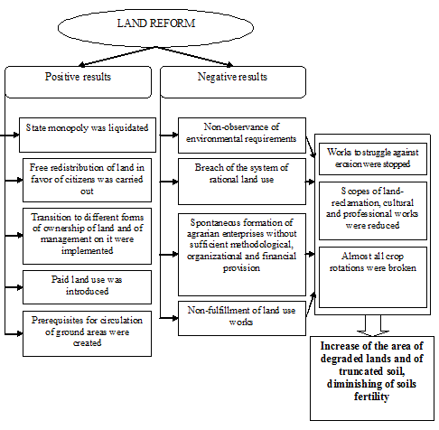
Figure 1 — Results of land reform
So changes in land ownership led to the breach of the existing setup of the land use territory and influenced considerably the structure of lands and the sown areas of the crops [1].
Setup of the agricultural enterprise territory is defined by land utilization projects, which ensure the eco-economic basis of crop rotations and grounds regulation, in which types and kinds of crop rotations are formed on the scientific basis, placing of objects of an infrastructure is supposed, measures for land protection, their rational use and increase of productivity of soils, etc. are assigned.
To correct the situation, which has emerged as a consequence of transformations, the Verkhovna Rada of Ukraine at the legislative level obliged agricultural commodity producers to carry out the use of agricultural holdings only based on developed and approved in accordance with established procedure land utilization projects, which ensure the eco-economic basis of crop rotations and grounds regulation.
Analysis of changes made by the Law of Ukraine “About insertion of changes in some legislative acts of Ukraine concerning maintenance of soils fertility” has shown that the legislation has made an attempt to establish control of use of agricultural lands. However, in the modern period only several land utilization projects are developed and approved in Ukraine. So long as there are many obstacles for this. Firstly, the Cabinet of Ministers of Ukraine has not yet adopted necessary by-law normative legal acts, particularly order of development of Projects. Secondly, not every land use planning enterprise is ready to implement such project design works. Besides, development of land utilization projects, which ensure the eco-economic basis of crop rotations and grounds regulation, by itself is also connected with a whole complex of problems (for instance, with identification of rights to land (not all land lease contracts pass proper registration); use of lands of community property (fields cut through “virtual” field roads and forest belts, which did not pass into private property during privatization); necessity to make changes in land lease contracts when redesigning ground structure, to register changes in the state land cadastre; change of standard pecuniary valuation of lands and land taxation, etc.) [6]. These are not even all reasons, by which process of development of these projects is idle.
However, in spite of complexity of situation it makes sense to the heads of agricultural enterprises to think about development of such projects. Since, as A.G. Martyn asserts [6], having received land utilization project, agrarians can choose lots for the in-house building, change if necessary structure of grounds of used acres, place forest plantations, in-house roads, etc. As well as according to the requirements of Law “About lease of land” after approval of the land utilization project period of validity of contracts of lease of ground areas of agricultural purpose to carry on commodity agricultural production agrarian must take into account period of rotation of main crop rotation that would let to agrarians to control leased areas of acres more efficiently.
Farm boundary adjustment
Main goal of farm boundary adjustment is the development of measures, which ensure rational use and protection of lands with simultaneous receipt of maximum profit from the economic activity on the land by a land user. Scientifically grounded project lies at the root of farm boundary adjustment. It represents the aggregate of documents (calculations, explanations, drafts) of the organization of territory of the agricultural enterprise. Land utilization project, which ensures the eco-economic basis of crop rotations and grounds regulation, always defines a new form of organization of territory that must promote the rise in the efficiency of production. Therefore, rational plan of land use is not only not offered in the project, but fixed designed decision is thoroughly grounded and proofs are adduced that in existing natural and socio-economic conditions proposed decision is the best [8].
Main reasons of making of land utilization projects, which ensure the eco-economic basis of crop rotations and grounds regulation, are changes in available land, which were carried out after farm reorganization, breach of existing crop rotations.
From the economic point of view Project must find the best farm specialization, combination of sectors and concentration level of farm production, rational structure of grounds, sown areas and system of crop rotations, establish necessary production expenditures for the farm centers placement, transformation and improvement of grounds, placement and arrangement of territory of crop rotations and other grounds for the purpose of receipt of maximum quantity of production when minimizing expenditures of means and work [7].
Composition and contents of the project depend on natural and socio-economic conditions, forms of land ownership and land use, farm specialization, composition and correlation of sectors, conditions of settling, and development of elements of an infrastructure. At the same time, in all instances the fixed range of questions, defining as a whole the process of farm boundary adjustment, must be considered (see fig. 2) [8].
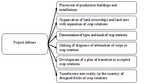
Figure 2 — Principal elements of Project
One of the principal constituent parts of the project is the organization of territory of crop rotations, the main purpose of which is to increase the intensity and to reveal reserves of growth of efficiency of land use based on taking into account of economic interests of landowners and land users.
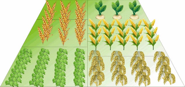
Figure 3 — Diagram of crop rotation
1 — perennial grasses, 2 — winter wheat, 3 — sugar beet, 4 — corn, 5 — barley.
Principal tasks of crop rotation:
-increase of soils fertility and rational use of soil nutrients;
-increase of the level of crop yield and an improvement of its quality;
-decrease of weed infestation of crops, their liability to diseases and vermin;
-decrease of negative influence of wind and water erosion [9].
Hence, the organization of territory rationally made, which takes into account requirements of environmental protection in a full measure, is an important factor of the increase of effectiveness of nature management.
Solid modeling
To run an agricultural enterprise producing the output of plant growing it is necessary to have the impartial information about dimensions and state of agricultural grounds. Big quantity of spatial and attributive information can be processed and analyzed in a quality manner only by the special software, taking into account both spatial linkage and special information about fields. Particularized geographic information systems for agriculture are not the rarity in Europe, and the USA long ago, and are the necessary component of the system of complex farm management. [10] Situation in Ukraine does not differ for the better.
Many problems of designing can be solved easier and more effectively with help of volume visualization. Among them are following:
- visualization of territory of agricultural enterprise;
- automatic construction of maps of relief slopes, as well as maps of maximum slopes;
- designing of placing of agricultural grounds and direction of ploughing up of slopes;
- planning and accomplishment of landslide protection and erosion-preventive measures, prevention of gullying.
Hence, electronic diagrams of fields - it is convenient, efficiently, possibility to make changes promptly, quick access to any information.
Conclusions
When carrying out land reform in Ukraine essential shortcomings were committed, whereby crop rotations were broken and destroyed, that caused an irrational and ineffective use of lands and their protection. Non-observance of measures of land protection, increase of anthropogenic negative influence on agricultural lands, decrease of volumes of land reclamation, cultural and technical works, and breach of the system of farming led to deterioration of land quality. These problems must be decided in land utilization projects, which ensure the eco-economic basis of crop rotations and grounds regulation.
In the master’s thesis scientific and technical task is decided, which consists in revelation of advantages and disadvantages of techniques of development of land utilization projects, which ensure the eco-economic basis of crop rotations and grounds regulation, creation and approval of the model of development of these projects at a concrete example.
Improvement of methods and approaches to formation and organization of territories of neogenic land ownerships and land uses of agricultural enterprises, development and implementation of changes in techniques of making of land utilization projects, will favor the rational use of agricultural grounds with receipt of maximum profit.
Literature:
1. Напрями формування сталого сільськогосподарського землекористування в умовах трансформації земельних відносин. Гуторов О.І., д-р екон. наук. Харківський національний аграрний університет ім. В.В. Докучаєва. [Електронний ресурс]. — Режим доступа: http://www.btsau.kiev.ua/files/list/edition/ed_dviyuualfz.pdf
2. Бабміндра Д.І. Еколого-економічні засади реформування землекористування в ринкових умовах. Автореферат дисертації на здобуття наукового ступеня доктора економічних наук. Київ 2004.
4. Правове забезпечення сівозмін [Електронний ресурс].— Ресурс доступа: http://www.agro-usiness.com.ua/component/content/article/215.html?ed=26 (офіційний сайт журналу «Агробізнес сьогодні»)
5. Необхідність розроблення проекту землеустрою щодо забезпечення еколого-економічного обгрунтування сівозміни та впорядкування угідь. [Електронний ресурс]. — Ресурс доступа: http://www.rv.gov.ua/sitenew/koretsk/ua/4546.htm (офіційний сайт Корецької державної адміністрації)
6. Земля обедованная. Романюк Елена Николаевна. Журнал Бизнес №8 (891) от 22.02.2010.
7. Бугаевская В. В. Экономическое обоснование проектов внутрихозяйственного землеустройства с использованием автоматизированных технологий: диссертация на получение научной степени кандидата экономических наук. — М, 1998. — 193 с.
8. Сулин М.А. Землеустройство. &mdash СПб.: Издательство «Лань», 2005. — 448 с. — (Учебник для вузов. Специальная литература).
9. Лапин А.Г., Усов М.А. Основы агрономии. — Ленинград: Гидрометиоиздат, 1990.
10. Построение агрономической ГИС. Демиденко А. Г., Слива И. В., Трубников А. Геоматика, №2'2009 [Електронний ресурс]. — Режим доступа: http://www.gisinfo.ru/item/64.htm