
Abstract
Content
- 1. Theme urgency
- 2. Goal and tasks
- 3. Investigation of the possibility of automation expert valuation of land parcels' using Quantum GIS
- 3.1 The logical structure of the database
- 3.2 Perform sampling
- 3.3 Creating a user extension
- Conclusions
- References
1. Theme urgency
Expert monetary valuation of land made under [1, art. 13]:
- exclusion and insurance land belonging to the state or municipal property, except as provided for in paragraph seven of this article;
- land security in accordance with the law;
- determining the investment in the implementation of the project on land improvement;
- determining the value of land belonging to the state or municipal property, if they are paid to statutory fund management company;
- the selection or determination of the state or territorial community as part of land that is shared property;
- display the value of land and land use rights in accounting in accordance with the laws of Ukraine;
- determine losses to land users or in cases established by law or contract;
- the court's decision.
In all other cases, the valuation of land can carried out with the consent of the parties and in the cases determined by this and other laws of Ukraine [1, art. 13].
Quality assessment depends on the effectiveness of methods used, the correctness of their use and providing the necessary information all stages of assessment [2].
In connection with the foregoing, it is an urgent task of developing information support for performance evaluation, one of the components of which is to automate performance estimation procedure.
2. Goal and tasks
The goal is to study the possibility of automation expert money estimation of land using Quantum GIS.
Tasks of the research:
- analysis of existing information support expert money estimation techniques and land use;
- study the shortcomings of the existing information support expert money estimation of land;
- creation of software facilities expert money estimation of land.
3. Investigation of the possibility of automation expert money valuation of land using Quantum GIS
To automate assessment procedures appropriate to apply a geographic information system. Currently on the market there are many geographic information systems programs, most of which are only available in the paid use. To investigate the possibility of automation expert money estimation of land was chosen as a free geographic information system free open source Quantum GIS (QGIS), which allows you to create and edit vector and raster data, create plugins for programming languages Python or C++ [4].
To investigate the methodological approach was chosen expert money estimation, which is based on a comparison of sales prices of such land. Under this approach, the value of land is determined by the amendment to the sales price of such land, taking into account the differences in the terms of the agreement and the characteristics that affect the cost of [3]. Adjusted selling price of land, estimated, given by:
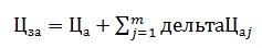
Цза – adjusted selling price and th such land (in hrn);
Ца – the actual sale price and th such land (in hrn);
m – number factors of comparison;
дельтаЦаj – difference (amendment) of the sale price and th such land relative to the estimated land, the j‑factor as a comparison;
The value of land is defined as the median or modal value of the results [3].
3.1 The logical structure of the database
Accordingly, for expert money estimation of various land can create a database that would have kept the information about the land from which you can make a selection of land with properties close to the estimated land.
To this end, we propose the following database structure (figure 1).

Figure 1 – The structure of the database
Next, perform sampling and ease of use – display of land position on the map. To do this, a geographic information system selected free open source Quantum GIS.
3.2 Perform sampling
To study the connectivity and operation of database applications to Quantum GIS (QGIS) were created table Land parcels'
and Parcel for value
using SQLite Database Browser [5]. SSQLite Database Browser – is cross‑platform embedded database that supports a fairly complete set of SQL commands and is available in source code [6]. These tables were connected to QGIS using tools Quantum GIS database manager (Manager database) (figure 2), which allows you to view the structure and content of tables

Figure 2 – Connecting tables to QGIS
To find the value of land necessary to carry out sampling analog objects similar to the characteristics of valued land. The sample can be done with SQL‑query. Manager database in its dialog box has a button SQL, when clicked, opens the query SQL. Sampling was carried out land located up to 3 km from the estimated land (figure 3)

Figure 3 – Execution of SQL‑queries
3.3 Creating a user extension
Quantum GIS – free custom GIS has developed an advanced API and system extensions (modules). Modules are designed to extend the functionality of the program. In QGIS built bindings (bindings), which implements almost all the functionality of QGIS programming language Python. Graphical user interface based on the QGIS libraries Qt. Development for QGIS can be conducted in two languages, Python and C++. To develop the necessary language Python bindings PyQt, providing interaction with Python Qt.
Create extension consists of several stages:
1) idea;
2) creating frame;
3) development of the necessary functionality;
4) testing;
Created expansion will add a new button to the toolbar to display text on the screen, add the menu Vector item to launch the calculator (figure 4, 5).

Figure 4 – Working enlargement Testplugin

Figure 5 – Working enlargement Calculator
Conclusions
The study showed the next results:
- Quantum GIS can be used to develop an information providing expert land valuation of land;
- Quantum GIS allows the creation of modules that extend the functionality of the program;
In the future it is planned to create a set of modules for connectivity, database processing, calculating the value of land that will allow someone who does not have the skills to handle the database or creating SQL‑query to perform expert valuation of the land.
References
- Закон України
Про оцінку земель
від 11.12.2003 № 1378//Відомості Верховної Ради, 2004 №15. - А. Н. Осипов Разработка информационного обеспечения для оценки земли и недвижимого имущества – [Електронний ресурс] – Режим доступу: http://masters.donntu.ru/publ2002/ggeo/osipov.pdf.
Методика експертної грошової оцінки земельних ділянок
, затверджена постановою Кабінету Міністрів України від 11.10.2002 № 1531 – [Електронний ресурс] – Режим доступу: http://zakon4.rada.gov.ua/laws/show/1531-2002-%D0%BF.- Quantum GIS свободная географическая информационная система с открытым кодом – [Електронний ресурс] – Режим доступу: http://www.qgis.org/ru/site/.
- SQLite DataBase Browser – [Електронний ресурс] – Режим доступу: http://sourceforge.net/projects/sqlitebrowser/.
- Qt Project – [Електронний ресурс] – Режим доступу: http://qt-project.org/doc/qt-4.8/designer-manual.html .
- SQlite – Встраиваемая БД – [Електронний ресурс] – Режим доступу: habrahabr.ru/post/149356/.