
Formation of new scientific and methodological approaches for obtaining reliable data to the normative monetary assessment of the lands of populated areas.
Contents
- Relevance
of the topic
- Purpose
- Types of monetary valuation for taxation
- Analysis of the reliability of the input data for the assessment
- Errors in the application of the expert>method of determining the coefficient Km2
- Land rent
- Conclusion
- List literature
Relevance of the topic
At all stages of the development of society, the earth was, is and will be the most important means of production, the basis, the basis, the foundation of human life. Without land, there can be no interaction between people who make up society and their very lives. The land is also one of the sources of the state's income through land tax, which is levied on the owners of land plots and land shares (units) and permanent land users. (1) .
In order to determine the land tax you need to conduct a monetary assessment of land . The ways of conducting it are different in different countries , for example: mass , cadastral, normative.
Many countries, having separated from the USSR, despite the absence of a land market during the transition period, have chosen the advanced European experience of assessing land resources for taxation.Ukraine, taking into account the fact that the formation of the land market is a long–term process, has chosen a normative approach to assessing land for taxation. The Donetsk People's Republic is at the stage of forming its regulatory and legislative base, therefore, during the transition period it is guided by the normative legal acts that operated on its territory until the moment of detachment from Ukraine and does not contradict the Constitution of the People's Republic of China. Namely, that the use of land in the Donetsk People's Republic is paid. The payment for land is levied in the form of land tax or rent, determined depending on the normative monetary assessment of land. (3) Therefore, at the current time, studies aimed at improving the scientific and methodological approaches to obtaining reliable data for the monetary valuation of land can be considered relevant.
Proceeding from the above, the purpose of this master's work is:
Analyze international methods of assessment, choose and prove in practice the method that is most suitable for the lands of the Donetsk People's Republic. Find disadvantages in the method and develop recommendations for its improvement.
To accomplish this goal, it is necessary to solve the following tasks:
1. Implement, in accordance with the existing methodology, the normative and monetary valuation of urban lands: Yenakiyevo, Khartsyzsk, Makeyevka, to identify and justify the deficiencies in the existing methodology.
2.Proanalizirovat compliance of land in the form of 6zem, to clarify the calculated base cost.
3.Development of recommendations for improving the method of normative and monetary evaluation, taking into account the identified remarks.
Types of monetary valuation for taxation
Estimation of real estate value – the process of determining the value of an object or individual rights with respect to the property being valued. Estimation of real estate value includes: determining the value of ownership or other rights, for example, the right to lease, the right to use and t. etc. with respect to various properties.
Table 1 – Comparison of types of monetary valuation for taxation
| View | Definition | Evaluation unit | Countries | Market Accounting | Evaluation methods | Purpose of evaluation | Disadvantages of use |
| Mass | The process of determining the cost when grouping objects with similar parameters and applying the simulation of their value. | Market Range | USA, England, Germany, Sweden, Australia, and others. | is tied up in the developed market | market cost of comparison, cost of substitution and capitalization of income. | Determination of land tax | she Mee t errors, especially when used over time, or to estimate a complex object with insufficient data |
| Cadastral | Estimation of the consumer value of land plots of settlements within the boundaries of cadastral accounting | Cadastral block, block | Russian Federation, Belarus, Kazakhstan, Lithuania, etc. | is tied up in the developed market | comparative, costly and profitable. | Determination of land tax | It does not always correspond to reality because of what the land tax on some land can be understated or overstated. |
| Normative | It is used to determine the size of land tax, loss of agricultural and forestry production, economic incentives for rational use and protection of lands, etc. | Estimated area | Ukraine | Excluding the market | capitalization of rental income | Determination of land tax | In small settlements, as the transport system is not developed or absent in them, it is impossible to use a normative monetary estimate and use the method of peer review. |
Mass evaluation involves a systematic assessment of property groups at a given date using a standardized procedure. It must also comply with the requirements of local legislation. All of the censors must be supported by market evidence and high quality. Mass evaluation processes are aimed at providing reliable and consistent data that lie within the market range. However, they also make mistakes, especially when they are used over time or to evaluate complex objects or insufficient data (3).
Mass land valuation is based on three traditional approaches: the market value of comparison, the cost of substitution and capitalization of income. In the process of mass evaluation, the combination of all three approaches is usually used to determine the taxable value (Fig. 1). Different types of land can be subject to different approaches to evaluation depending on their characteristics, legal basis and availability of trusted market data.
The need for mass evaluation developed when governments began applying property taxes that required a large number of real estate properties that were valued at the same time, while maintaining a low cost of valuation. It is generally accepted that all landowners must pay fair taxes. (4)
Mass evaluation of land for tax purposes began to develop at the beginning of the 20th century, when it became possible to apply relatively inexpensive homogeneous, accurate and fair approaches to the valuation of all real estate objects. The impetus for widespread use of mass evaluation was the rapid development of statistical models and computer technologies (5) .

Despite the fact that the mass appraisal for tax purposes is a relatively low–cost interventions, for its application in the territory of Ukraine, and later, and the DNI, the time has not come yet because of the weak and uneven development of the land market.
Post–Soviet countries once Nome reacted to monetary valuation of land. They borrowed international experience and tried to build a valuation method similar to the mass one. So the Russian Federation, Byelorussia and Kazakhstan Lithuania and others are subject to a cadastral valuation. In Ukraine , the normative monetary estimate is applied .
In the Russian Federation, a cadastral valuation of the lands of populated areas is applied, it is an important part of the updating of the land cadastre. Cadastral valuation of land settlements – is an estimate of the consumer value of land plots of settlements within the boundaries of cadastral accounting (cadastral block, quarter).
The cadastral value is the value in monetary terms, obtained as a result of the cadastral valuation.
Price is based in the village more part, at the corresponding value of the land in the village, which has the worst ( free ) conditions and an additional one, representing the cost for better conditions.
The cadastral valuation, like the massive one, is tied to the developed land market, for which it is impossible to use this estimate throughout the territory. Cadastral valuation, although applied in the Russian Federation, but there are a lot of contradictions. It does not always correspond to reality because of what the land tax on some land can be understated or overstated. But the erroneous land tax can be challenged with the help of expert monetary assessment, which entails additional expenses for taxpayers. (6)
In the context of the mass valuation system, the lack of reliable data on the land market is limited. The housing market is the only developed market, which is characterized by a large number of trading operations. These operations are distributed unevenly throughout the country, for example, large cities are characterized by many transactions and high prices for apartments, while in small towns and villages there are few examples of real estate sales. Official data from land registration authorities can not be used as a source of data, since private traders often hide the current market price in order to avoid paying transfer taxes.
But in the current political and economic situation, this estimate can only be applied in large cities, but not even in all areas, but only in those where the land market is well developed. In the rest of the territory this assessment can not be applied.
In the conditions of the formation of the land market, its lack of transparency, insufficient information on sales of land plots, mass evaluation land has The greatest value , representing a method, obtaining estimates of market value indicators of a homogeneous group of land plots, using market information. In the conditions of market formation, mass valuation of lands allows to form an approach to the analysis of the whole range of available information, which can be used later by refinements in the implementation of individual (single) assessment. Mass evaluation is the basis for land taxation.
Ukraine uses the normative
monetary value and (NDO). NDO of land plots
according to art. 201 of the Land Code
of Ukraine,]
It is used to determine the size of the
land tax, the loss of agricultural and forestry production, economic
incentives of rational land use and protection, and so on. n (7) .
And
in accordance with Art. 5 of the Law of Ukraine On
the evaluation of land
The land NDO
is used to determine the amount of land tax, the state fee for
the change, inheritance and donation of land plots, rent for land
plots of state and municipal property, losses of agricultural and
forestry production, as well as in developing indicators and
mechanisms for economic incentives for the rational use and
protection of land (8) .
Historically, in Ukraine, there were three separate methodical directions for carrying out the normative monetary assessment of lands, namely:
agricultural land;
settlements;
land for non–agricultural purposes outside the populated areas.
At the heart of the normative monetary assessment of the land of settlements is the capitalization of rental income arising from the location of the settlement in the nation–wide, regional and local production and settlement system, the arrangement of its territory and the quality of land, taking into account the natural and climatic and engineering–geological conditions, landscape and historical and cultural value, ecological condition, functional use of lands.
Normative monetary assessment is excellent for areas with a weakly developed land market. It takes into account the location and all the raising factors that affect the evaluation site. But it does not always reflect reality, research is constantly carried out to improve it, scientists are looking for new and new opportunities to reduce the errors in the assessment (9) .
Analysis of the reliability of the input data for the assessment.
The first problem with what an appraiser encounters when carrying out a normative monetary assessment is the reliability of the input data for evaluation.
The initial data used are extensive and diverse information (Fig. 2) , contained in different units of measure, in order to bring the land–value indicators into a single system, the coefficients of the relative value of the territories or the relative values – scores are used.

At the heart of the normative monetary assessment of the lands of settlements is the capitalization of rental income, obtained depending on the location of the settlement in the nation–wide, regional and local production and settlement systems, the arrangement of its territory and the quality of land, taking into account the natural, climatic and engineering–geological conditions, – landscape and historical and cultural value, ecological condition, functional use of lands.
Settlements include all categories of land for the main designated purpose, which are located within their administrative boundaries.
Baseline data for calculating Km are general plans and plans for the planning and development of settlements, plans for their land and economic structure, and materials for the economic evaluation of their territories.
The calculation of the point for location is based on the characteristic of the distance (distance) of the locality from the centers with a higher social and economic potential, i.e. the location of each settlement in the district settlement system is estimated . The total score for the location includes the calculation of points for the distance to the regional center, the district center, the center of the rural settlement, and also takes into account the availability of types of transport accessibility.
Errors in the application of the expert method of determining the coefficient Km2
Methods of expert estimations are the part of a vast field of decision theory first, and very expert evaluation – the procedure for obtaining the problem of assessment based on the opinions of experts with a view to subsequent decision.
One of their main drawbacks is that the reliability and reliability of the research primarily depend on the competence of the specialists involved in the process . There are no guarantees that the estimates obtained are in fact valid. The existing methods for determining the reliability of expert assessments are based on the assumption that in the case of consistency of expert opinions, the reliability of the estimates is guaranteed. With this statement, it is not always possible to agree, since there are cases when individual experts who disagree with the majority opinion gave correct estimates.
The procedure for the monetary valuation of agricultural land and settlements in determining the values ??of the regional coefficient Km2, taking into account the impact on the monetary value of Rent forming regional factors partially accounted geographical position settlements. At the same time, some of the important aspects of the geographical situation remain unheeded, as experts have repeatedly pointed out. Another issue is that in order to determine the quantitative values ??of the impact of certain aspects of the geographical location of settlements on the value of their territory, the necessary fundamental scientific research.
Land rent
The basis of land policy in cities is land rent. Land rent is the income received by the land owner from the tenants of land. Land rent is in the form of absolute rent, differential rent and monopoly rent.
The principles of the formation of differential land rent are sufficiently fully and comprehensively studied by foreign classics. In the overwhelming majority, only the economic aspects of the problem are analyzed. The explanation for this can be found in the fact that abroad , where the real estate market has been formed for several centuries , the geographical features of rent can be of purely theoretical interest. In Ukraine there was a different situation. The development of the land and real estate market in cities is in the initial stage of formation, therefore, the establishment of many indicators used in monetary valuation is based on the statutory normative indicators.
At the first stage of the normative monetary assessment of any settlement, the base cost of 1 m? of land is determined, which depends on the location of the settlement in the national, regional and local schemes of production and resettlement and the level of development and development of its territory.
At the second stage, the base cost is differentiated within the boundaries of the settlement according to economic and planning zones, which are established depending on the heterogeneity of the functional and planning qualities of the territory that affect the amount of rental income: differences in accessibility, engineering support of the territory, development of the service sector in the environmental quality of territory and attractiveness of the environment.
At the third stage, the cost of one square meter of a land plot of a certain functional use is determined, taking into account the geographic, engineering, geological, historical–cultural, natural–landscape, sanitary–hygienic and engineering–infrastructural features of its location .
The reliability of the evaluation results largely depend on the quality of m input data and the selected technology. Currently, all technologies for the monetary valuation of land and real estate are geoinformation systems that will allow to link the spatial characteristics of land with various attributive information to them (10).
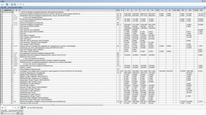
One
of the sources of information for the normative monetary evaluation
of land plots is the form of state statistical reporting of land
resources – 6–zem. Since this form since 1998 was
formed at the initial stage in the manual mode
in
the Microsoft document Excel , and then
semi–automatic and automatic modes in different software products,
its data is very difficult to adhere to geospatial data
lands of the village.
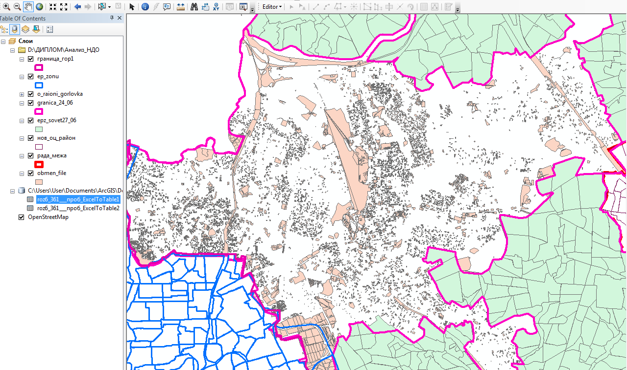
At this stage of research on the example of the form 6–zem and available land exchange files Yenakiyevo cities Hartsyzk and Makiyivka ( Figure 3) are considered two options of preparation technology of these data for regulatory monetary valuation of land:
1 embodiment – in
manual mode
communicate data from 6–zem spatial data (Fig. 4 );2 mbodiment – the formation of mold 6 in geodetic zem geoinformation system GIS–6 to form an additional image with the spatial data, which is subsequently used for normative monetary value land settlements.
Conclusion
Testing
of the first embodiment of the technology shown to be associated
uniquely in manual mode
6–zem data with spatial location
is almost impossible – requires a lot of additional data, the
preparation of which would require additional costs.
Despite the fact that the second option is still in development, we can draw the following conclusion: the addition to the program, forming automatic statistical reporting form, a module for creating an additional file with spatial data will significantly improve the quality and productivity in the calculation of the base cost.
List literature
1. Лихогруд М. Денежная оценка земли важная составная земельной реформы // Пропозиция. – № 11 – 2001.
2. Закон ДНР
О налоговой системе
№ 99IHC от 25.12.2015//
[Электронный ресурс]. – Режим доступа:
http://dnrsovet.su/zakononalogovojsistemedonetskojnarodnojrespubliki/
.
3. MASS APPRAISAL, 2017г, 62с. [Электронный ресурс], Режим доступа: http://www.mass.gov/dor/docs/dls/publ/101handbook/chapter2.pdf, Дата посещения 04.07.2017 г.
4. Valuation of single residential land – 20170 14с [электронный ресурс] –http://www.valuergeneral.nsw.gov.au/__data/assets/pdf_file/0004/198625/0.2_ FINAL_Valuation_of_single_residential_land_policy_May_2017.pdf Дата посещения 04.07.2017 г.
5. Массовая оценка городских земель как фундамент градостроительства и управления недвижимостью/ C.B. Орлов и др. // Экономика строительства. –2000. – № 11. – С.2135.
6. Ромм А П. Кадастровая оценка городских земель: методические основы и инструментальные средства. // Вопросы оценки. 1997. – № 3. – с. 1620. .
7. Земельний кодекс України від 25 жовтня 2001 року № 2768–III//Офіційний вісник України від 30.11.2001 – 2001 р., № 46, стор. 1, стаття 2038, код акту 20473/2001.
8. 2. Закон
України Про оцінку земель
від 16 жовтня
2012 року N 5462–VI//Офіційний вісник України
від від 23.01.2004 – 2004 р., № 1, стор. 7, стаття
1, код акту 27360/2004.
9. Третяк А. М. Развитие рынка земли в Украине // Землеустроительный вестник. –2000. –№ 1 (на укр. языке). .
10. Методичні основи грошової оцінки земель в Україні: Наук. видання / Дехтяренко Ю.Ф., Лихогруд М.Г., Манцевич Ю.М., Палеха Ю.М. – К.: ПРОФІ, 2002. – 258 с. .