
Nadezhda A Panasenkova
Faculty
: Mining and geologicalSpeciality
: Geoinformation systems and technologiesTheme of master´s work
:"Accuracy´s estimation of ortophotomap´s structuring in the Photogrammetric station Delta"
Leader of work
: lecturer Sholomitskiy Andrey ArkadevichSummary
1 Introduction2 Purpose of work
3 Estimated scientific novelty
4 Estimated practical value
5 Current status review of research theme
6 List of unsolved problems
7 The planned and received results
8 Conclusion
9. List of references
1 Introduction
The intensive progress in the field of cards visualization technologies has already led to spreading digital of cards everywhere which quickly supersede paper maps. Now digital cards are three-dimensional, volumetric. In present time development of digital technologies, satellite navigating systems and systems of remote geodata gathering affects completeness, reliability of the cartographical information, on ways of its representation, and the organization of access to it. At this moment there is a set of examples of high technologies introduction [7].
Geographical information systems integrate all science fields, manufacture and education. GIS has wide functional abilities, powerful information resources, huge analytical opportunities and simplicity of development. Here's the information on spheres of application of digital images, and the plans. These plans are used for GIS creation and operation.
2 Purpose of work
To realize a posed task a following work complex originally executed:
- preparation of initial raster images and additional information;
- performance of internal, mutual and external orientation of pictures;
- processing of a phototriangulation by program BlockMSG;
- shooting of a situation and a relief in career on stereomodels and drawing of conventional signs;
- drawing up ortophotomap of career within the allocated pictures limits;
- accuracy's estimation of model's structuring and calculations of coordinates;
- creation of ortoobjects;
- comparison and the analysis of stereo- and ortoobjects.
In the considered methods of estimation [4, 8, 9] images are processed in system Photomod; location relief is flat, the digital model of relief is not precise.
In my work I'm analysing ortofotoplan, created by Photogrammetric station Delta. The ortophotoplans basis is airphotos of "Vostochnyiy" quarry by Dokuchaevsk industrial complex. Middle scale of pictures is 1:8000, a height of photographing is 800 �. A difference between the extreme values of marks makes about 200 m.
4 Estimated practical value
It is known that exactness of automatic receipt of digital information about relief on bitmapped images is conditioned by snapshots scanning errors, internal and external orientation of the images. The indicated processes result in appearance of geometrical and photogrammetrical errors. These mistakes distort final product, which include application of ortophotoplans. Therefore control of quality is important for creation of ortophotoplans [8].
5 Current status review of research theme
For the research of Current status review of my theme I've studied some digital photogrammetric stations and found out algorithms and methods of Accuracy's estimation of ortophotomap?s structuring.
Photomode system makes Accuracy's estimation of ortophotomap?s structuring by various altitude matrices [4].
By method [8] ortophotoplan's distort depends on geometrical and photogrammetrical mistakes.
By method [9] ortophotoplan's distort depends on mistake of relief's digital model and on the size of scanning pixel.
6 List of unsolved problems
Developing the method of Accuracy's estimation of ortophotomap?s structuring. The part of my work is to resolve this question, because method of Accuracy's estimation for Delta has not been previously investigated in literature.
Digital photogrammetric system's products are digital ortophotomap and vectorial model of an object, and it is important to know interaction between them [13]. My research is based on the analysis vectorial model of objects.
7 The planned and received results
To realize a posed task the following of complex work originally has been executed. The following performance of measurements and the analysis have been performed.
A choice of objects:
- dot objects (electricity supplement lines)
- stationary objects with unequivocally certain contours (auxiliary constructions)
- lines of a relief (top, bottom angle edge)
Possible variants of the decision:
- definition of linear deviations
- closed loop definition
The Method of comparison: comparison of contours and the centers of objects constructed in a stereo mode and on ortophotomaps.
Comparison of linear objects is executed as it is shown on Fig. 1-a. Comparison of closed loop is executed as it is shown on Fig. 1-b. Thus, unitary linear measurement completely characterizes size of a deviation along whole investigated contour. The length of the constructed line also will be dot size of deviation. After definition of deviation area, the average deviation on the given site is counted.
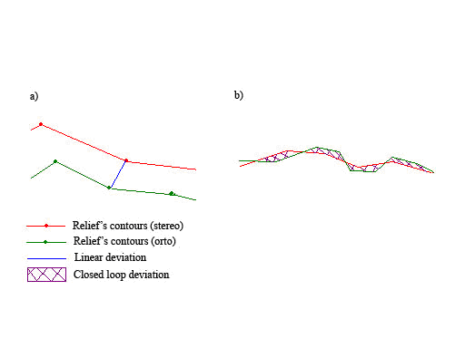
Fig. 1 - Comparison of linear and closed loop objects
As the implementation result of measuring of about 300 contours of relief have bee processed, 10 contours of buildings, 50 dotted objects. The value of rejections depends on place of location of contour.
When contour identification problem appears rejection was 8-10 m. On 80% of objects rejection was 0.5 m. In rest of cases it was 1.5-2 m.
After implementation of measuring, I am planning to execute the statistical analysis of rejections.
9. List of references
Refereces in RUS